Who What Where WhenREMOVEWHATShow MoreWHERE
|
Author
Marshall, John
Full Title
A Map of those parts of Virginia, North Carolina, South Carolina, & Georgia, which were the scenes of the most important Operations of the Southern Armies. Compiled by S. Lewis. Engraved for the Life of Washington. Plate VIII. Engraved by Francis Shallus. Published by C.P. Wayne. Philadelphia. (1807)
Publisher
C.P. Wayne
Author
Marshall, John
Full Title
Plan of the Investment and Attack of York in Virginia. Engraved for the Life of Washington. Plate IX. Engraved by Francis Shallus. Published by C.P. Wayne. Philada. (1807)
Publisher
C.P. Wayne
Author
Marshall, John
Full Title
Plan of the Siege of Charleston in S. Carolina. Engraved for Washington's Life. Plate X. Drawn by S. Lewis. Tanner, Sc. Published by C.P. Wayne. Philadelphia. (1807)
Publisher
C.P. Wayne
Author
[Delarochette, Louis Stanislas d'Arcy, Faden, William, 1750?-1836]
Full Title
(Covers to) Colombia Prima or South America, In which it has been attempted to delineate the Extent of our Knowledge of that Continent Extracted Chiefly from the Original Manuscript Maps of His Excellency the late Chevalier Pinto Likewise from those of Joao Joaquin da Rocha, Joao da Costa Ferreira, El Padre Francisco Manuel Sobrevielo &c. And From the most Authentic Edited Accounts of Those Countries. Digested and Constructed by The late eminent and learned Geographer Louis Stanislas D'Arcy de la Rochette. London. Published by William Faden, Geographer to His Majesty and to His Royal Highness the Prince of Wales, June 4, 1807.
Publisher
William Faden
Author
[Delarochette, Louis Stanislas d'Arcy, Faden, William, 1750?-1836]
Full Title
Sheet 1. South America.
Publisher
William Faden
Author
[Delarochette, Louis Stanislas d'Arcy, Faden, William, 1750?-1836]
Full Title
Sheet 2. South America.
Publisher
William Faden
Author
[Delarochette, Louis Stanislas d'Arcy, Faden, William, 1750?-1836]
Full Title
Sheet 3. South America.
Publisher
William Faden
Author
[Delarochette, Louis Stanislas d'Arcy, Faden, William, 1750?-1836]
Full Title
Sheet 4. South America.
Publisher
William Faden
Author
[Delarochette, Louis Stanislas d'Arcy, Faden, William, 1750?-1836]
Full Title
Sheet 5. South America.
Publisher
William Faden
Author
[Delarochette, Louis Stanislas d'Arcy, Faden, William, 1750?-1836]
Full Title
Sheet 6. South America.
Publisher
William Faden
Author
[Delarochette, Louis Stanislas d'Arcy, Faden, William, 1750?-1836]
Full Title
Sheet 7. South America.
Publisher
William Faden
Author
[Delarochette, Louis Stanislas d'Arcy, Faden, William, 1750?-1836]
Full Title
Sheet 8. South America.
Publisher
William Faden
Author
[Delarochette, Louis Stanislas d'Arcy, Faden, William, 1750?-1836]
Full Title
Sheets 1-8. South America.
Publisher
William Faden
Author
Arrowsmith, Aaron
Full Title
Map of Upper Egypt, drawn from various documents. By A. Arrowsmith. London, Published A. Arrowsmith, No.10 Soho Square, 20th November, 1807.
Publisher
A. Arrowsmith
Author
Arrowsmith, Aaron
Full Title
(Upper Sheet to) A Map of Lower Egypt from Various Surveys communicated by Major Bryce and other Officers. Drawn by A. Arrowsmith 1807. London, Published A. Arrowsmith, No.10 Soho Square, 10th November, 1807.
Publisher
A. Arrowsmith
Author
Arrowsmith, Aaron
Full Title
(Lower Sheet to) A Map of Lower Egypt from Various Surveys communicated by Major Bryce and other Officers. Drawn by A. Arrowsmith 1807. London, Published A. Arrowsmith, No.10 Soho Square, 10th November, 1807.
Publisher
A. Arrowsmith
Author
Arrowsmith, Aaron
Full Title
(Composite map of) A Map of Lower Egypt from Various Surveys communicated by Major Bryce and other Officers. Drawn by A. Arrowsmith 1807. London, Published A. Arrowsmith, No.10 Soho Square, 10th November, 1807.
Publisher
A. Arrowsmith
Author
[Arrowsmith, Aaron, Columbine, Edward Henry]
Full Title
(Chart of Shetland Isles and Orkney Islands). A, Arrowsmith Hydrographer to H.R.H. the Prince of Wales. London. Published June 25th 1807 by A A. Arrowsmith 10 Soho Square. J Palmer Scult. (inset) Island of Unst : A Part of the N.E. Coast of the Shetland Isles. Surveyed in Jany. 1795 by Lieut. Columbine. Scale (ca. 63,360). (title on verso) Scotland N.E. Coast, Shetland Isles ... Firth of Inverness ... Thurso Bay ... Orkney Islands. (0n lower right margin) 1419.
Publisher
A. Arrowsmith
Author
Melish, John
Full Title
(Covers to) (Untitled Atlas of 12 Outline and Keyed Maps).
Publisher
(John Melish)
Author
Melish, John
Full Title
A: (Untitled landform map).
Publisher
(John Melish)
Author
Melish, John
Full Title
B: (Untitled outline map of the World).
Publisher
(John Melish)
Author
Melish, John
Full Title
C: (Untitled outline map of North America).
Publisher
(John Melish)
Author
Melish, John
Full Title
D: (Untitled outline map of the United States).
Publisher
(John Melish)
Author
Melish, John
Full Title
E: (Untitled outline map of South America).
Publisher
(John Melish)
Author
Melish, John
Full Title
F: (Untitled outline map of Europe).
Publisher
(John Melish)
Author
Melish, John
Full Title
G: (Untitled outline map of England).
Publisher
(John Melish)
Author
Melish, John
Full Title
H: (Untitled outline map of Scotland). (untitled inset: Shetland Islands).
Publisher
(John Melish)
Author
Melish, John
Full Title
I: (Untitled outline map of Ireland).
Publisher
(John Melish)
Author
Melish, John
Full Title
K: (Untitled outline map of Asia).
Publisher
(John Melish)
Author
Melish, John
Full Title
L: (Untitled outline map of Africa).
Publisher
(John Melish)
Author
Melish, John
Full Title
M: (Untitled outline map of Pennsylvania).
Publisher
(John Melish)
Author
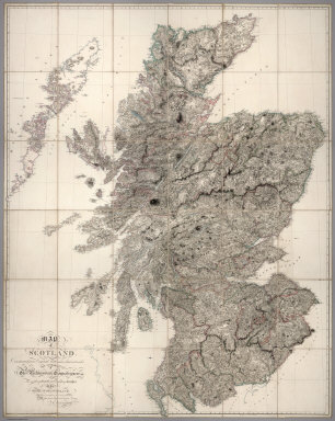
Arrowsmith, Aaron
Full Title
Map of Scotland Constructed from Original Materials Obtained under The Authority of The Parliamentary Commissioners For making Roads and building Bridges In the Highlands of Scotland With whose permission it is now published By Their most obliged and obedient Servant A.Arrowsmith Hydrographer to H.R.H. the Prince of Wales. London. Published June 25th. 1807 by A. Arrowsmith 10 Soho Square
Publisher
A. Arrowsmith
Author
Arrowsmith, A.
Full Title
(Northwest Section) Map of South Italy and Adjacent Coasts.
Publisher
A. Arrowsmith
Author
Arrowsmith, A.
Full Title
(Northeast Section) Map of South Italy and Adjacent Coasts.
Publisher
A. Arrowsmith
Author
Arrowsmith, A.
Full Title
(Southwest Section) Map of South Italy and Adjacent Coasts.
Publisher
A. Arrowsmith
Author
Arrowsmith, A.
Full Title
(Southeast Section) Map of South Italy and Adjacent Coasts.
Publisher
A. Arrowsmith
Author
Arrowsmith, A.
Full Title
(Composite Map) Map of South Italy and Adjacent Coasts.
Publisher
A. Arrowsmith
Author
Humboldt, Alexander von, 1769-1859
Full Title
Carte Reduite de la Route d' Acapulco a Mexico, Dresee sur des Observations Astronomiques et sur un nivellement Barometrique par A. de Humboldt. 5. Dessine par A. de Humboldt, a Berlin 1807. Grave par Barriere et l'Ecriture par L. Aubert.
Publisher
F. Schoell
Author
Humboldt, Alexander von, 1769-1859
Full Title
Carte de la Route qui mene depuis la Capitale de la Nouvelle Espagne jusqu'a S. Fe de Nouveau Mexique. Dressee sur les Journaux de Don Pedro de Rivera et en partie sur les Observations Astronomiques de Mr. de Humboldt. 6-8. Dessine et redige par F. Friesen, a Berlin 1807.
Publisher
F. Schoell
Author
Humboldt, Alexander von, 1769-1859
Full Title
Carte reduite de la Partie oreintale de la Nouvelle Espagne depuis le Plateau de la Ville de Mexico jusqu'au Port de la Veracruz. Dressee sur les operations Geodesiques de Don Miguel Costanzo et de Dn. Dgo. Garcia Conde, Officers au Service de Sa Majeste Catholique sur les Observations Astronomiques et le Nivellement Barometrique de Mr. De Humboldt. 9. Dessinee d'apres l'esquise de Mr. de Humboldt par F. Friesen, a Berlin 1807. Le Plan grave par Barriere et l'Ecriture par L. Aubert, directeur du dit ouve. a Paris.
Publisher
F. Schoell
Author
Humboldt, Alexander von, 1769-1859
Full Title
Plan du Port de Veracruz, Dresse par Don Bernardo de Orta, Capitaine de Vaisseau au service de Sa Majeste Catholique. 11. F. Bauza s. a Madrid. (copie et diminue de moitie par F. Wittich 1807.) d'apres le Plan publie par le Deposito hydrografico de Madrid. Le Plan grave par Barriere et l'Ecriture par L. Aubert, directeur. Paris.
Publisher
F. Schoell
Author
Humboldt, Alexander von, 1769-1859
Full Title
Tableau physique de la pente Orientale du Plateau de la Nouvelle Espagne (Chemin de Mexico a Veracruz par Puebla et Xalapa.) Dresse d'apres des mesures Barometriques et Trigonometriques, prises en 1804 par Mr. de Humboldt. 12. Dessine par A. de Humboldt, a Veracruz 1804. Termine par Wittich et Friesen 1807. Grave par Bouquet. Les Echelles et l'Ecriture gravees par Aubert.
Publisher
F. Schoell
Author
Humboldt, Alexander von, 1769-1859
Full Title
Tableau physique de la pente Occidental du Plateau de la Nouvelle Espagne (Chemin de Mexico a Acapulco) Dresse d'apres des mesures Barometriques prises en 1803 par Mr. de Humboldt. 13. Dessine par Wittich d'apres une esquise de Mr. Humboldt 1807. Grave par Bouquet. Les Echelles et l'Ecriture gravees par Aubert.
Publisher
F. Schoell
Author
Humboldt, Alexander von, 1769-1859
Full Title
Tableau du Plateau central des Montagnes du Mexique, entre les 19 et 21¼ de Latitude boreale (Chemin de Mexico a Guanaxuato) Dresse d'apres le Nivellement Barometrique de Mr. de Humboldt. 14. Esquise par Alex. Mr. Humboldt a Mexico 1803. Dessine par Raphael Davalos a Mexico 1804 (termine a Berlin 1807). Grave par Bouquet. Les Echelles et l'Ecriture gravees par Aubert.
Publisher
F. Schoell
Author
Humboldt, Alexander von, 1769-1859
Full Title
Volcans de la Puebla, vus depuis la Ville de Mexico de l'Imprimerie de Langlois. 16. Fr. Gmelin perf. Romae 1805. Lud. Martin ad nat. del. 1803. Fr. Arnold sc. Berol. 1807.
Publisher
F. Schoell
Author
Humboldt, Alexander von, 1769-1859
Full Title
Pic d' Orizaba vu depuis la Foret de Xalapa. de l'Imprimerie de Langlois. 17. Fr. Gmelin perf. Romae 1805. A. de Humboldt ad nat. del. 1804. Fr. Arnold sc. Berol. 1807.
Publisher
F. Schoell
Author
Cary, John, ca. 1754-1835
Full Title
A new map of the British Isles, from the latest authorities. By John Cary, engraver, 1807. (with) Shetland Isles. London: Published for J. Cary, Engraver & Map-seller, No. 181, Strand, July 1st, 1807.
Publisher
John Cary
Author
Cary, John, ca. 1754-1835
Full Title
A new map of England, from the latest authorities. By John Cary, engraver, 1807. London, Published by J. Cary, Engraver & Map-seller, No. 181, Strand, Decr. 1st, 1807.
Publisher
John Cary
Author
Cary, John, ca. 1754-1835
Full Title
A new map of Nova Scotia, Newfoundland &c. from the latest authorities. By John Cary, engraver. 1807. London: Published by J. Cary, Engraver & Map-seller, No. 181, Strand, Decr. 1st, 1807.
Publisher
John Cary
Author
Cary, John, ca. 1754-1835
Full Title
A new map of Upper & Lower Canada, from the latest authorities. By John Cary, engraver. 1807. London: Published by J. Cary, Engraver & Map-seller, No. 181, Strand, Decr. 1st, 1807.
Publisher
John Cary
|