Browse All

1812 Maine. World Atlas Maine. (Boston: Published by Thomas & An … |

1812 Vermont. World Atlas Vermont. Drawn by S. Lewis. Engd. by D. … |

1812 Rhode Island. World Atlas Rhode Island. (Boston: Published by Thom … |

1812 Connecticut. World Atlas Connecticut. Drawn by S. Lewis. (Boston: … |

1812 New York. World Atlas New York. Drawn by S. Lewis. Tanner sc. … |

1812 New Jersey. World Atlas New Jersey. Drawn by S. Lewis. Tanner sc … |

1812 Pennsylvania. World Atlas Pennsylvania. Drawn by S. Lewis. Engd. b … |

1812 Delaware. World Atlas Delaware. (Boston: Published by Thomas & … |

1812 Maryland. World Atlas Maryland. (Boston: Published by Thomas & … |

1812 Virginia. World Atlas Virginia. S. Lewis del. (Boston: Publish … |

1812 North Carolina. World Atlas North Carolina. Drawn by S. Lewis. Tanne … |

1812 South Carolina. World Atlas South Carolina. Drawn by S. Lewis. Engd. … |

1812 Georgia. World Atlas Georgia. Drawn by S. Lewis. D. Fairman s … |

1812 Kentucky. World Atlas Kentucky. Drawn by S. Lewis & eng'd. by … |

1812 Tennessee. World Atlas Tennessee. Drawn by S. Lewis. Engraved b … |

1812 Ohio. World Atlas Ohio. (Boston: Published by Thomas & And … |

1812 Mississippi Territory. World Atlas Mississippi Territory. Drawn by S. Lewis … |

1812 Louisiana. World Atlas Louisiana. Drawn by S. Lewis. Tanner sc. … |

1812 British possessions in America. World Atlas British Possessions in America. Jones sc … |

1812 Spanish dominions in North America. World Atlas Spanish Dominions in North America. From … |

1812 New Granada. World Atlas Viceroyalty of New Granada. (Boston: Pub … |

1812 Caracas, Guiana. World Atlas Government of Caracas, with Guiana. (Bos … |

1812 Peru. World Atlas Viceroyalty of Peru. (Boston: Published … |

1812 Chili. World Atlas Chili. (Boston: Published by Thomas & An … |

1812 La Plata. World Atlas Viceroyalty of La Plata. (Boston: Publis … |

1812 West Indies. World Atlas West Indies. From various authorities. ( … |

1812 South America. World Atlas South America. Hooker sculpt. (Boston: P … |

1812 Africa. World Atlas Africa. From Arrowsmith's map of Africa. … |

1812 Egypt. World Atlas Egypt. From D'Anville. Ruld. by Hooker. … |

1812 West Africa. World Atlas West Africa. Shallus sc. (Boston: Publis … |

1812 Cape Colony. World Atlas Colony of the Cape of Good Hope. From Mr … |
1812 Top sheet: Chart of the East India Islan … Chart Map (Top sheet of) Chart of the East India I … |

1812 Bottom sheet: Chart of the East India Is … Chart Map (Bottom sheet of) Chart of the East Indi … |

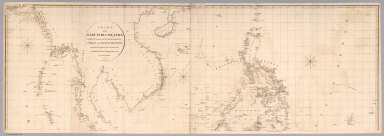
1812 Composite: Chart of the East India Islan … Chart Map (Composite of) Chart of the East India I … |

1812 Covers: Germany. Case Map (Covers to) To His Royal Highness the Du … |

1812 Lower Left: Germany. Case Map (Lower Left) To His Royal Highness the D … |

1812 Lower Right: Germany. Case Map (Lower Right) To His Royal Highness the … |

1812 Upper Left: Germany. Case Map (Upper Left) To His Royal Highness the D … |

1812 Upper Right: Germany. Case Map (Upper Right) To His Royal Highness the … |

1812 Composite: Germany. Case Map (Composite Map) To His Royal Highness th … |

1812 America. Wall Map Map of America by A. Arrowsmith. Philade … |

1812 Northern Part of the State Of New York Case Map Map Of The Northern Part of the State Of … |

1812 Covers: Northern Part of the State Of Ne … Case Map (Covers to) Map Of The Northern Part of … |

1812 Composite: United States of Nth. America … Separate Map (Composite of) United States of Nth. Ame … |

1812 Sheet 1: United States of Nth. America. Separate Map (Sheet 1) United States of Nth. America. … |

1812 Sheet 2: United States of Nth. America. Separate Map (Sheet 2) United States of Nth. America. … |

1812 Sheet 3: United States of Nth. America. Separate Map (Sheet 3) United States of Nth. America. … |

1812 Sheet 4: United States of Nth. America. Separate Map (Sheet 4) United States of Nth. America. … |

1812 Title Page: Travels in the United States … Exploration Book (Title Page to) Travels in the United St … |

1812 Map of the United States of America. Exploration Book Map of the United States of America. J. … |