Who What Where WhenREMOVEWHERE
|
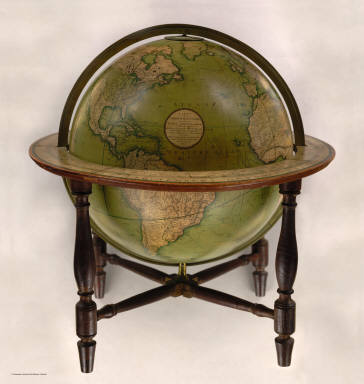
Author
[Cary, John, ca. 1754-1835, Cary, William]
Full Title
Cary's New Terrestrial Globe Exhibiting The Tracks and Discoveries made by Captain Cook; Also those of Captain Vancouver on the Northwest Coast of America and M. De La Perouse, On the Coast of Tartary, Together With every other Improvement collected from Various Navigators and Travellers to the present time. London: Made & Sold by J. & W. Cary, Strand, March 1st, 1816. With Corrections and Additions to 1818.
Publisher
J. & W. Cary
Author
[Birkbeck, Morris, Melish, John]
Full Title
(Title Page to) Letters From Illinois By Morris Birkbeck ... Illustrated by a Map of the United States, Shewing Mr. Birkbeck's Journey From Norfolk To Illinois And a Map of English Prairie and the Adjacent Country, by John Melish. Philadelphia: Published By M. Carey & Son, 126, Chestnut Street. 1818.
Publisher
M. Carey & Son
Author
[Birkbeck, Morris, Melish, John]
Full Title
United States. Published 1st June 1816 by J. Melish. Philadelphia. Improved to 1818.
Publisher
M. Carey & Son
Author
[Birkbeck, Morris, Melish, John]
Full Title
English Prairie and Adjacent Country. T.V.K & Co. Sc. J. Melish Del.
Publisher
M. Carey & Son
Author
Maclure, William
Full Title
(Title Page to) Transactions of the American Philosophical Society. New Series. No. I. Observations on the Geology of the United States of North America; with Remarks on the probable Effects that may be produced by the Decomposition of the different Classes of Rocks on the Nature and Fertility of Soils: applied to the different States of the Union, agreeably to the accompanying geological Map. With two Copper Plates. By William Maclure. Read May 16th, 1817.
Publisher
A. Small
Author
Maclure, William
Full Title
Map of the United States of America. J. Melish del. Designed to illustrate the Geological Memoir of Wm. Maclure Esqr. Transactions American Philosophical Society, Vol. I. New Series. Entered ... and Published by John Melish, Philadelphia.
Publisher
A. Small
Author
Carey, Mathew
Full Title
(Covers to) Carey's General Atlas, Improved And Enlarged; Being A Collection Of Maps Of The World And Quarters, Their Principal Empires, Kingdoms, &c. Containing...[List of Maps]. Philadelphia: Published By M. Carey And Son, 1818.
Publisher
M. Carey and Son
Author
Carey, Mathew
Full Title
(Title Page to) Carey's General Atlas, Improved And Enlarged; Being A Collection Of Maps Of The World And Quarters, Their Principal Empires, Kingdoms, &c. Containing...[Sequential List of Maps]. Philadelphia: Published By M. Carey And Son, 1818.
Publisher
M. Carey and Son
Author
Carey, Mathew
Full Title
(Prefatory Remarks 1 to) Carey's General Atlas, Improved And Enlarged; Being A Collection Of Maps Of The World And Quarters, Their Principal Empires, Kingdoms, &c. Containing...[List of Maps]. Philadelphia: Published By M. Carey And Son, 1818.
Publisher
M. Carey and Son
Author
Carey, Mathew
Full Title
(Prefatory Remarks 2 to) Carey's General Atlas, Improved And Enlarged; Being A Collection Of Maps Of The World And Quarters, Their Principal Empires, Kingdoms, &c. Containing...[List of Maps]. Philadelphia: Published By M. Carey And Son, 1818.
Publisher
M. Carey and Son
Author
Carey, Mathew
Full Title
A Map of the World from the best Authorities. J. Bower, Sc.
Publisher
M. Carey and Son
Author
Carey, Mathew
Full Title
A Chart of the World According to Mercators Projection, Shewing the latest Discoveries of Capt. Cook.
Publisher
M. Carey and Son
Author
Carey, Mathew
Full Title
A New and Accurate Map of North America from the best Authorities. Bower Sc.
Publisher
M. Carey and Son
Author
Carey, Mathew
Full Title
Map of the United States of America. Gridley Sc.
Publisher
M. Carey and Son
Author
Carey, Mathew
Full Title
Vermont From actual Survey. Delineated & Engraved by Amos Doolittle N.H.
Publisher
M. Carey and Son
Author
Carey, Mathew
Full Title
The District of Maine. Engrd. by John G. Warnicke.
Publisher
M. Carey and Son
Author
Carey, Mathew
Full Title
The State of Massachusetts.
Publisher
M. Carey and Son
Author
Carey, Mathew
Full Title
The State of Rhode Island compiled from the Surveys and Observations of Caleb Harris. By Harding Harris.
Publisher
M. Carey and Son
Author
Carey, Mathew
Full Title
Connecticut From the best Authorities. Delineated & Engraved by A. Doolittle. N. Haven.
Publisher
M. Carey and Son
Author
Carey, Mathew
Full Title
The State of New York. S. Lewis del. J.G. Warnicke Sc.
Publisher
M. Carey and Son
Author
Carey, Mathew
Full Title
The State of New Jersey Compiled from the most Authentic Information. Compiled by Samuel Lewis.
Publisher
M. Carey and Son
Author
Carey, Mathew
Full Title
Pennsylvania.
Publisher
M. Carey and Son
Author
Carey, Mathew
Full Title
Delaware, from the best Authorities.
Publisher
M. Carey and Son
Author
Carey, Mathew
Full Title
Maryland. (with) inset map Western Part of Maryland.
Publisher
M. Carey and Son
Author
Carey, Mathew
Full Title
A Correct Map of Virginia.
Publisher
M. Carey and Son
Author
Carey, Mathew
Full Title
North Carolina. S. Lewis Del. Wm. Charles Sc. (with) inset map North Carolina Western Parts Continued.
Publisher
M. Carey and Son
Author
Carey, Mathew
Full Title
The State of South Carolina: from the best Authorities, By Samuel Lewis. W. Barker, sculp.
Publisher
M. Carey and Son
Author
Carey, Mathew
Full Title
The State of Georgia. Gridley sc.
Publisher
M. Carey and Son
Author
Carey, Mathew
Full Title
Kentucky. Gridley sc.
Publisher
M. Carey and Son
Author
Carey, Mathew
Full Title
The State of Tennessee.
Publisher
M. Carey and Son
Author
Carey, Mathew
Full Title
The State of Mississippi and Alabama Territory. Shallus Sc.
Publisher
M. Carey and Son
Author
Carey, Mathew
Full Title
The State of Ohio with part of Upper Canada, &c.
Publisher
M. Carey and Son
Author
Carey, Mathew
Full Title
The Upper Territories of the United States. Kneass & Delleker Sc.
Publisher
M. Carey and Son
Author
Carey, Mathew
Full Title
Louisiana.
Publisher
M. Carey and Son
Author
Carey, Mathew
Full Title
Missouri Territory formerly Louisiana. Bower, Sc.
Publisher
M. Carey and Son
Author
Carey, Mathew
Full Title
Plat of The Seven Ranges Of Townships being Part of the Territory of the United States N.W. of the River Ohio Which by a late act of Congress are directed to be sold. Surveyed in conformity to an Ordinance of Congress of May 20th 1785. Under direction of Thos. Hutchins late Geographer to the United States.
Publisher
M. Carey and Son
Author
Carey, Mathew
Full Title
Mexico or New Spain. (with) inset map of southern Mexico and Central America.
Publisher
M. Carey and Son
Author
Carey, Mathew
Full Title
West Indies.
Publisher
M. Carey and Son
Author
Carey, Mathew
Full Title
Carte De La Partie Francoise De St. Domingue Faite par Bellin Ingr. de la Marine et depuis augmentee par P.C. Varle et autres Ingis. A Map Of The French Part Of St. Domingo. J.T. Scott, Sculp., Philada.
Publisher
M. Carey and Son
Author
Carey, Mathew
Full Title
A New Map of South America From the Latest Authorities.
Publisher
M. Carey and Son
Author
Carey, Mathew
Full Title
A New Map of the Caracas. Warnicke Sc.
Publisher
M. Carey and Son
Author
Carey, Mathew
Full Title
Peru. (with) inset map of eastern Peru.
Publisher
M. Carey and Son
Author
Carey, Mathew
Full Title
Chili And Part Of The Viceroyalty Of La Plata. Lewis delin. W. Robinson Sc.
Publisher
M. Carey and Son
Author
Carey, Mathew
Full Title
A Map of Brazil, now called New Portugal.
Publisher
M. Carey and Son
Author
Carey, Mathew
Full Title
Europe. Bower.
Publisher
M. Carey and Son
Author
Carey, Mathew
Full Title
Sweden, Denmark, and Norway. Kneass Young & Co. Sc.
Publisher
M. Carey and Son
Author
Carey, Mathew
Full Title
The Russian Empire, in Europe and Asia.
Publisher
M. Carey and Son
Author
Carey, Mathew
Full Title
Scotland. (inset) Shetland Islands.
Publisher
M. Carey and Son
Author
Carey, Mathew
Full Title
An Accurate Map of England and Wales With The Principal Roads from the best Authorities.
Publisher
M. Carey and Son
|