Who What Where WhenREMOVEWHATShow MoreWHERE
WHOShow More |
Author
[Thomson, John, Wyld, James, 1790-1836]
Full Title
United States. Drawn by Wyld. Engraved by Hewitt. Published by John Thomson & Co. Edinburgh. (to accompany) A General Atlas, Containing Maps illustrating some important periods in Ancient History; and distinct Maps of the several Empires, Kingdoms and States In The World, From Original Drawings according to the latest Treaties by J. Wyld and Engraved by N.R. Hewitt. Edinburgh, Printed for John Thomson & Co for Baldwin, Cradock & Joy, London & John Cumming, Dublin.
Publisher
John Thomson
Author
[Thomson, John, Wyld, James, 1790-1836]
Full Title
West Indies. Drawn by Wyld. Engraved by Hewitt. Published by John Thomson & Co. Edinburgh. (to accompany) A General Atlas, Containing Maps illustrating some important periods in Ancient History; and distinct Maps of the several Empires, Kingdoms and States In The World, From Original Drawings according to the latest Treaties by J. Wyld and Engraved by N.R. Hewitt. Edinburgh, Printed for John Thomson & Co for Baldwin, Cradock & Joy, London & John Cumming, Dublin.
Publisher
John Thomson
Author
[Thomson, John, Wyld, James, 1790-1836]
Full Title
South America. Drawn by Wyld. (engraved by) Hewitt Sc. ... Published by John Thomson & Co. Edinburgh. (to accompany) A General Atlas, Containing Maps illustrating some important periods in Ancient History; and distinct Maps of the several Empires, Kingdoms and States In The World, From Original Drawings according to the latest Treaties by J. Wyld and Engraved by N.R. Hewitt. Edinburgh, Printed for John Thomson & Co for Baldwin, Cradock & Joy, London & John Cumming, Dublin.
Publisher
John Thomson
Author
[Thomson, John, Wyld, James, 1790-1836]
Full Title
Map of Van Diemans Land ; Map of part of New South Wales. Drawn and engraved by W.H. Lizars. Edin(burgh). (to accompany) A General Atlas, Containing Maps illustrating some important periods in Ancient History; and distinct Maps of the several Empires, Kingdoms and States In The World, From Original Drawings according to the latest Treaties by J. Wyld and Engraved by N.R. Hewitt. Edinburgh, Printed for John Thomson & Co for Baldwin, Cradock & Joy, London & John Cumming, Dublin.
Publisher
John Thomson
Author
[Thomson, John, Wyld, James, 1790-1836]
Full Title
Discoveries Capts. Ross, Parry & Franklin in the Arctic Regions. in 1818, 1819, 1820, 1821 & 1822. (Published by John Thomson & Co. Edinburgh.) (to accompany) A General Atlas, Containing Maps illustrating some important periods in Ancient History; and distinct Maps of the several Empires, Kingdoms and States In The World, From Original Drawings according to the latest Treaties by J. Wyld and Engraved by N.R. Hewitt. Edinburgh, Printed for John Thomson & Co for Baldwin, Cradock & Joy, London & John Cumming, Dublin.
Publisher
John Thomson
Author
[Thomson, John, Wyld, James, 1790-1836]
Full Title
South America. (inset) Guatemala or the Republic of Central America. (Published by John Thomson & Co. Edinburgh.) (to accompany) A General Atlas, Containing Maps illustrating some important periods in Ancient History; and distinct Maps of the several Empires, Kingdoms and States In The World, From Original Drawings according to the latest Treaties by J. Wyld and Engraved by N.R. Hewitt. Edinburgh, Printed for John Thomson & Co for Baldwin, Cradock & Joy, London & John Cumming, Dublin.
Publisher
John Thomson
Author
[Thomson, John, Wyld, James, 1790-1836]
Full Title
Mexico and Internal Provinces. (Published by John Thomson & Co. Edinburgh.) (to accompany) A General Atlas, Containing Maps illustrating some important periods in Ancient History; and distinct Maps of the several Empires, Kingdoms and States In The World, From Original Drawings according to the latest Treaties by J. Wyld and Engraved by N.R. Hewitt. Edinburgh, Printed for John Thomson & Co for Baldwin, Cradock & Joy, London & John Cumming, Dublin.
Publisher
John Thomson
Author
[Thomson, John, Wyld, James, 1790-1836]
Full Title
(Index Page to) Consulting Index for the Ancient Maps. Printed by John Pillans, Edinburgh. (to accompany) A General Atlas, Containing Maps illustrating some important periods in Ancient History; and distinct Maps of the several Empires, Kingdoms and States In The World, From Original Drawings according to the latest Treaties by J. Wyld and Engraved by N.R. Hewitt. Edinburgh, Printed for John Thomson & Co for Baldwin, Cradock & Joy, London & John Cumming, Dublin.
Publisher
John Thomson
Author
[Thomson, John, Wyld, James, 1790-1836]
Full Title
(Index Page to) Consulting Index for the Modern Maps. Printed by John Pillans, Edinburgh. (to accompany) A General Atlas, Containing Maps illustrating some important periods in Ancient History; and distinct Maps of the several Empires, Kingdoms and States In The World, From Original Drawings according to the latest Treaties by J. Wyld and Engraved by N.R. Hewitt. Edinburgh, Printed for John Thomson & Co for Baldwin, Cradock & Joy, London & John Cumming, Dublin.
Publisher
John Thomson
Author
[Lea, I., Carey, H.C.]
Full Title
New York. Drawn by F. Lucas, Jr. Engd. by J. Yeager. (inset) Profile of Levels of the Grand Canal.
Publisher
H.C. Carey & I. Lea.
Author
Woodbridge, William C.
Full Title
(Covers to) A System of Universal Geography, On The Principles of Comparison and Classification; By William Channing Woodbridge ... Illustrated With Maps and Engravings; And Accompanied by an Atlas ... (with) Ancient Geography, As Connected With Chronology, And Preparatory to the Study of Ancient History: By Emma Willard ... Hartford: Oliver D. Cooke & Sons. 1824. (on verso) ... on the eleventh day of June ... (1824) ... William C. Woodbridge ... and Emma Willard ... have deposited ... a Book ... Connecticut.
Publisher
Oliver D. Cooke & Sons
Author
Woodbridge, William C.
Full Title
(Title Page to) A System of Universal Geography, On The Principles of Comparison and Classification; By William Channing Woodbridge ... Illustrated With Maps and Engravings; And Accompanied by an Atlas ... (with) Ancient Geography, As Connected With Chronology, And Preparatory to the Study of Ancient History: By Emma Willard ... Hartford: Oliver D. Cooke & Sons. 1824. (on verso) ... on the eleventh day of June ... (1824) ... William C. Woodbridge ... and Emma Willard ... have deposited ... a Book ... Connecticut.
Publisher
Oliver D. Cooke & Sons
Author
Woodbridge, William C.
Full Title
Counties Of England. (Accompany) A System of Universal Geography, On The Principles of Comparison and Classification; By William Channing Woodbridge ... Illustrated With Maps and Engravings; And Accompanied by an Atlas ... (with) Ancient Geography, As Connected With Chronology, And Preparatory to the Study of Ancient History: By Emma Willard ... Hartford: Oliver D. Cooke & Sons. 1824. (on verso) ... on the eleventh day of June ... (1824) ... William C. Woodbridge ... and Emma Willard ... have deposited ... a Book ... Connecticut.
Publisher
Oliver D. Cooke & Sons
Author
Woodbridge, William C.
Full Title
German States. (Accompany) A System of Universal Geography, On The Principles of Comparison and Classification; By William Channing Woodbridge ... Illustrated With Maps and Engravings; And Accompanied by an Atlas ... (with) Ancient Geography, As Connected With Chronology, And Preparatory to the Study of Ancient History: By Emma Willard ... Hartford: Oliver D. Cooke & Sons. 1824. (on verso) ... on the eleventh day of June ... (1824) ... William C. Woodbridge ... and Emma Willard ... have deposited ... a Book ... Connecticut.
Publisher
Oliver D. Cooke & Sons
Author
Willard, Emma
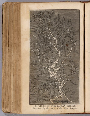
Full Title
Progress Of The Roman Empire, Illustrated By The course Of The River Amazon. (Accompany) A System of Universal Geography, On The Principles of Comparison and Classification; By William Channing Woodbridge ... Illustrated With Maps and Engravings; And Accompanied by an Atlas ... (with) Ancient Geography, As Connected With Chronology, And Preparatory to the Study of Ancient History: By Emma Willard ... Hartford: Oliver D. Cooke & Sons. 1824. (on verso) ... on the eleventh day of June ... (1824) ... William C. Woodbridge ... and Emma Willard ... have deposited ... a Book ... Connecticut.
Publisher
Oliver D. Cooke & Sons
Author
Willard, Emma
Full Title
(Title Page to) Ancient Geography, As Connected With Chronology, And Preparatory to the Study of Ancient History: By Emma Willard ... Hartford: Oliver D. Cooke & Sons. 1824. (on verso) ... on the eleventh day of June ... (1824). (with) A System of Universal Geography, On The Principles of Comparison and Classification; By William Channing Woodbridge ... Illustrated With Maps and Engravings; And Accompanied by an Atlas ... William C. Woodbridge ... and Emma Willard ... have deposited ... a Book ... Connecticut.
Publisher
Oliver D. Cooke & Sons
Author
Willard, Emma
Full Title
The Ancient World According to Strabo. (Accompany) Ancient Geography, As Connected With Chronology, And Preparatory to the Study of Ancient History: By Emma Willard ... Hartford: Oliver D. Cooke & Sons. 1824. (on verso) ... on the eleventh day of June ... (1824). (with) A System of Universal Geography, On The Principles of Comparison and Classification; By William Channing Woodbridge ... Illustrated With Maps and Engravings; And Accompanied by an Atlas ... William C. Woodbridge ... and Emma Willard ... have deposited ... a Book ... Connecticut.
Publisher
Oliver D. Cooke & Sons
Author
Woodbridge, William C.
Full Title
London; Edinburgh. (Accompany) Ancient Geography, As Connected With Chronology, And Preparatory to the Study of Ancient History: By Emma Willard ... Hartford: Oliver D. Cooke & Sons. 1824. (on verso) ... on the eleventh day of June ... (1824). (with) A System of Universal Geography, On The Principles of Comparison and Classification; By William Channing Woodbridge ... Illustrated With Maps and Engravings; And Accompanied by an Atlas ... William C. Woodbridge ... and Emma Willard ... have deposited ... a Book ... Connecticut.
Publisher
Oliver D. Cooke & Sons
Author
Klinckowstrom, Axel Leonhard
Full Title
Plan of Philadelphia. (Stockholm) Stente af Muller (1824)
Publisher
C. Muller
Author
Klinckowstrom, Axel Leonhard
Full Title
Third Street i Philadelphia. Rit. af Klinckowstrom. Gr. af Akrell. (Stockholm: Stente af C. Muller, 1824)
Publisher
C. Muller
Author
Klinckowstrom, Axel Leonhard
Full Title
Gerards Bank i Philadelphia. Rit. af Klinckowstrom. Gr. af Akrell. (Stockholm: Stente af C. Muller, 1824)
Publisher
C. Muller
Author
Klinckowstrom, Axel Leonhard
Full Title
Bro ofver Skuyukill strommen nara Philadelphia. Rit af Klinckowstrom. Gr. af Akrell. (Stockholm: Stente af C. Muller, 1824)
Publisher
C. Muller
Author
Klinckowstrom, Axel Leonhard
Full Title
Flyglarna af capitolen i Washington ar 1819. (Stockholm: Stente af C. Muller, 1824)
Publisher
C. Muller
Author
Klinckowstrom, Axel Leonhard
Full Title
Esquisse af Wards tafla i Mr. Earles Galleri i Philadelphia. (Stockholm: Stente af C. Muller, 1824)
Publisher
C. Muller
Author
Klinckowstrom, Axel Leonhard
Full Title
Perkins nyligen uppfundre Elldslacknings Spruter. Klinckowstrom del. (Stockholm: Stente af C. Muller, 1824)
Publisher
C. Muller
Author
Klinckowstrom, Axel Leonhard
Full Title
New York med Trakten Daromkring. (Stockholm: Stente af C. Muller, 1824)
Publisher
C. Muller
Author
Klinckowstrom, Axel Leonhard
Full Title
Brodway-gatan och Radhuset i Newyork. Rit. af Klinckowstrom. Gr. af Akrell. (Stockholm: Stente af C. Muller, 1824)
Publisher
C. Muller
Author
Klinckowstrom, Axel Leonhard
Full Title
Inrednings ritning till ett vanligt litet boningshus af trad i Newyork, Newyerssey och Pensylvania Staterne. (Stockholm: Stente af C. Muller, 1824)
Publisher
C. Muller
Author
Klinckowstrom, Axel Leonhard
Full Title
Angfartyget Chancellor Liwingston. Rit af Klinckowstrom. Gr. af Akrell. (Stockholm: Stente af C. Muller, 1824)
Publisher
C. Muller
Author
Klinckowstrom, Axel Leonhard
Full Title
Ruiner efter en gammal fastning i Tenessee Staten. (Stockholm: Stente af C. Muller, 1824)
Publisher
C. Muller
Author
Klinckowstrom, Axel Leonhard
Full Title
Newyorks Hamn och Redd Fran Brooklyn pa Longisland. Rit. af Klinckowstrom. Gr. af Akrell. (Stockholm: Stente af C. Muller, 1824)
Publisher
C. Muller
Author
Klinckowstrom, Axel Leonhard
Full Title
Hoboken midt emot Newyork. Rit. af Klinckowstrom. Gr. af Akrell. (Stockholm: Stente af C. Muller, 1824)
Publisher
C. Muller
Author
Klinckowstrom, Axel Leonhard
Full Title
Covers to: Atlas til Friherre Klinckowstroms Bref om de Forente Staterne. (Stockholm) Stente af C. Muller, (1824)
Publisher
C. Muller
Author
Klinckowstrom, Axel Leonhard
Full Title
Title Page to: Atlas til Friherre Klinckowstroms Bref om de Forente Staterne. (Stockholm) Stente af C. Muller, (1824)
Publisher
C. Muller
Author
Klinckowstrom, Axel Leonhard
Full Title
Contents to: Atlas til Friherre Klinckowstroms Bref om de Forente Staterne. (Stockholm) Stente af C. Muller, (1824)
Publisher
C. Muller
Author
Klinckowstrom, Axel Leonhard
Full Title
Beskrifning ofver Tryck-pumpen, tillhorande de Eldstacknings-Sprutor och andra hydrauliska maschiner, som aro uppfunna och tillverkade af Perkins och Jones i Philadelphia. (Stockholm) Stente af C. Muller, (1824)
Publisher
C. Muller
Author
Melish, John
Full Title
(Covers to) A General Collection Of Maps, Charts, Views, &c. ... Philadelphia. 1824.
Publisher
No publisher.
Author
Melish, John
Full Title
(Title Page to) A General Collection Of Maps, Charts, Views, &c. ... Philadelphia. 1824.
Publisher
No publisher.
Author
Melish, John
Full Title
A Map of the World from the Best Authorities. Western Hemisphere. Eastern Hemisphere. Thackara & Vallance. (1824)
Publisher
No publisher.
Author
Melish, John
Full Title
Part of North of Europe. (1824)
Publisher
No publisher.
Author
Melish, John
Full Title
Map of the United States of America. Designed to Illustrate the Geological Memoir of Wm. Maclure Esqr. Entered as the Act directs, and Published by John Melish, Philadelphia. Transactions American Philosophical Society Vol. 1 New Series. (1824)
Publisher
John Melish
|