1832
Pacific Ocean.
World Atlas
Pacific Ocean, by J. Arrowsmith. London,
…
|

1832
Mexico.
World Atlas
Mexico, by J. Arrowsmith. (with) Mexico,
…
|

1832
West Indies.
World Atlas
West Indies, by J. Arrowsmith. London, p
…
|

1832
Brazil.
World Atlas
Brazil, by J. Arrowsmith. London, pubd.
…
|

1830
New England, N.Y. 1697.
National Atlas
New England and New York in 1697. From t
…
|

1831
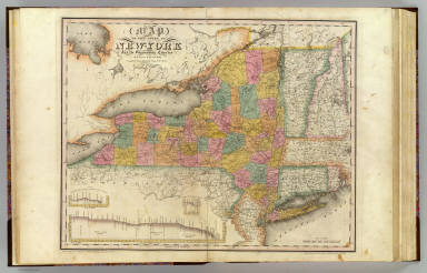
New York.
National Atlas
Map of the state of New York, with part
…
|

1831
Kentucky, Tennessee.
National Atlas
Map of the states of Kentucky and Tennes
…
|

1831
Virginia, Maryland.
National Atlas
Map of the states of Virginia and Maryla
…
|

1831
Alabama, Georgia.
National Atlas
Map of the states of Alabama and Georgia
…
|

1830
New England States.
School Atlas
New England States. Entered ... 12th day
…
|

1830
Middle States.
School Atlas
The Middle States, Maryland & Virginia.
…
|

1830
United States.
School Atlas
United States. Entered ... 12th day of A
…
|

1830
N. & S. America.
School Atlas
North America. South America. Entered ..
…
|

1830
Atlantic Ocean.
School Atlas
Atlantic Ocean, its islands & coasts. En
…
|

1830
Europe.
School Atlas
Europe. Entered ... 12th day of Augut 18
…
|

1830
Africa.
School Atlas
Africa. Entered ... 12th day of August 1
…
|

1830
Asia.
School Atlas
Asia. Entered ... 12th day of August 183
…
|

1830
Pacific Ocean.
School Atlas
Pacific Ocean, its islands & coasts. Ent
…
|

1830
Hemispheres.
School Atlas
Western Hemishere, Eastern Hemisphere, N
…
|

1830
Mountains, rivers.
School Atlas
Height of the principal mountains on the
…
|

1830
Picture of the World.
School Atlas
Picture of the World. Entered ... 12th d
…
|

1832
Carte du Monde connu des anciens.
World Atlas
Carte du Monde connu des anciens. Dresse
…
|

1832
L'Empire d'Alexandre.
World Atlas
Carte de l'Empire d'Alexandre. Dressee p
…
|

1832
L'Empire Romain.
World Atlas
Carte de l'Empire Romain. Dressee par Mr
…
|

1832
Italie ancienne.
World Atlas
Carte de l'Italie Ancienne, dressee par
…
|

1832
Grece ancienne.
World Atlas
Carte de la Grece Ancienne. Dressee par
…
|

1832
Mappe-monde.
World Atlas
Mappe-monde sur la projection de Mercato
…
|

1832
Turquie d'Europe, Grece.
World Atlas
Carte de la Turquie d'Europe et de la Gr
…
|

1832
La Grece.
World Atlas
Carte de la Grece et de l'Archipel. Dres
…
|

1832
L'Asie.
World Atlas
Carte de l'Asie. Dressee par Mr. Lapie,
…
|

1832
Empire Chinois, Japon.
World Atlas
Carte de l'Empire Chinois et du Japon. D
…
|

1832
Siberie, Russie d'Asie.
World Atlas
Carte de la Siberie ou Russie d'Asie. Dr
…
|

1832
Etats-Unis d'Amerique.
World Atlas
Carte des Etats-Unis d'Amerique, du Cana
…
|

1832
Westliche Halbkugel, 1832
World Atlas
Westliche Halbkugel. Entw. u. gez. von F
…
|

1832
Des Osmanischen Reichs europaischer Thei
…
World Atlas
Des Osmanischen Reichs europaischer Thei
…
|

1832
Nord-America, 1832
World Atlas
Nord-America ; entwrfen u. gezeichnet vo
…
|

1832
Oestliche Halbkugel. (Eastern Hemisphere
…
World Atlas
No. V. Stieler's Hand-Atlas No. 7. Oestl
…
|

1832
Des Osmanischen Reichs europaqischer The
…
World Atlas
No. XLI. Stieler's Hand-Atlas (No. 38).
…
|

1832
New-York State, surrounding country.
State Atlas
Map of the State of New-York and the sur
…
|

1832
New York City & County.
State Atlas
Map of the City and County of New York w
…
|

1832
Facsimile: Part of Venezuela, Guiana by
…
National Atlas
(Facsimile) Arrowsmith - 1832. 47. S Doc
…
|

1832
Ancient Italy I.
World Atlas
Ancient Italy I. Published under the sup
…
|

1832
Italy I.
World Atlas
Italy I. Published under the superintend
…
|

1832
Austrian Dominions III.
World Atlas
Austrian Dominions III. Croatia, Sclavon
…
|

1832
India III. Bombay Presidency.
World Atlas
India III. Bombay Presidency. J. & C. Wa
…
|

1832
India IV.
World Atlas
India IV. J. & C. Walker sculpt. Publish
…
|

1832
Germany. Deutschland II.
World Atlas
Germany. Deutschland II. Eastern part of
…
|

1832
Germany. Deutschland III.
World Atlas
Germany. Deutschland III. Baden, Wurtemb
…
|

1832
Germany. Deutschland IV. Austrian Domini
…
World Atlas
Germany. Deutschland IV. Austrian Domini
…
|

1832
Austrian Dominions II.
World Atlas
Austrian Dominions II. Galizia, eastern
…
|