Browse All

1837 Hydro-Historische Darstellung vom Zustan … World Atlas Hydro-Historische Darstellung vom Zustan … |

1837 Hydro-Historische Ubersicht vom Zustande … World Atlas Hydro-Historische Ubersicht vom Zustande … |

1837 Darstellung Der Isodynamischen Linien. World Atlas Darstellung Der Isodynamischen Linien, n … |

1837 Tripoli. World Atlas North Africa or Barbary IV. Tripoli. Pub … |

1837 Tripoli, Egypt. World Atlas North Africa or Barbary V. Parts of Trip … |

1837 S. Brazil, Paraguay, Uruguay. World Atlas South America sheet III. South Brazil wi … |

1837 Brussels. Bruxelles. World Atlas Brussels. Bruxelles. Published under the … |

1837 Copenhagen, Kiobenhaven. World Atlas Copenhagen. Kiobenhaven. Published under … |

1837 Dublin environs. World Atlas The environs of Dublin. Drawn & engraved … |

1837 Frankfort. Frankfurt am Mayn. World Atlas Frankfort. Frankfurt am Mayn. Published … |

1837 Russie occidentale, Pologne. World Atlas Carte de la Russie occidentale et du Roy … |

1837 Iles Antilles, Etats-Unis de l'Amerique … World Atlas Carte des Iles Antilles, des Etats-Unis … |

1837 Iles Antilles ou des Indes Occidentales. World Atlas Carte particuliere des Iles Antilles ou … |

1837 British North America. World Atlas British North America, by permission ded … |

1837 Upper Canada. World Atlas Upper Canada &c., by J. Arrowsmith. Lond … |

1837 Lower Canada. World Atlas Lower Canada, New Brunswick, Nova Scotia … |

1837 Route of the Western railroad. West of C … Pamphlet Route of the Western railroad. West of C … |

1837 Route of the Western railroad. East of C … Pamphlet Route of the Western railroad. East of C … |

1829 The world. School Atlas The World on a globular projection. Ente … |

1829 North America. School Atlas North America. Entered according to Act … |

1828 United States. School Atlas United States. Entered according to Act. … |

1829 Eastern States. School Atlas Eastern States. Entered according to Act … |

1829 South America. School Atlas South America. Entered according to Act. … |

1829 Europe. School Atlas Europe. Entered according to Act. of Con … |

1829 Asia. School Atlas Asia. Entered according to Act. of Congr … |

1829 Africa. School Atlas Africa. Entered according to Act. of Con … |

1837 Amberg National Atlas Amberg. Entworfen und bearbeitet von Woe … |

1837 Klattau National Atlas Klattau. Entworfen und bearbeitet von Wo … |

1837 Ingolstadt National Atlas Ingolstadt. Entworfen und bearbeitet von … |

1837 Regensburg National Atlas Regensburg. Entworfen und bearbeitet von … |

1837 Munchen National Atlas Munchen. Entworfen und bearbeitet von Wo … |

1837 Salzburg National Atlas Salzburg. Entworfen und bearbeitet von W … |

1827 Das Planeten - System. (The Planetary Sy … World Atlas No. II. Stielers Hand-Atlas (No. 4).Das … |

1832 Oestliche Halbkugel. (Eastern Hemisphere … World Atlas No. V. Stieler's Hand-Atlas No. 7. Oestl … |

1833 Europa. (Europe}. World Atlas No. XI. Stieler's Hand-Atlas No. 12. Eur … |

1835 Spanien und Portugal. (Spain and Portuga … World Atlas No. XII. Stieler's Hand-Atlas No. 13. Sp … |

1829 Frankreich und Umgebungen von Paris. (Fr … World Atlas No. XIII. Stieler's Hand-Atlas (No. 14.) … |

1823 Die Brittischen Inseln. (British Isles). World Atlas No. XVII. Stielers Hand-Atlas (No. 15). … |

1822 Danemark, Island u. Faroer, Schweden und … World Atlas Stielers Hand-Atlas (No. 16). Danemark, … |

1835 Daenemark mit Schleswig, Holstein, und L … World Atlas No. XXI. Stieler's Hand-Atlas (No. 16b.) … |

1831 Germany. Netherlands. Belgium. World Atlas No. XXVII. Stieler's Hand-Atlas (No. 21. … |

1831 Nord-Ostliches Deutschland. (Northeast G … World Atlas No. XXVIII. Stieler's Hand-Atlas (No. 22 … |

1833 Die Preussischen Provinzen, Preussen und … World Atlas No. XXIX. Stielers Hand-Atlas (No. 22b). … |

1834 Mittel-Ostliches Deutschland. (East Cent … World Atlas No. XXX. Stieler's Hand-Atlas (No. 23). … |

1835 Sudwestliches Deutschland ... Schweiz. ( … World Atlas No. XXXI. Stieler's Hand-Atlas (No. 24). … |

1836 Sud-Ostliches Deutschland .... (Southeas … World Atlas No. XXXII. Stieler's Hand-Atlas (No. 25) … |

1833 Der Rhein .... (Rhine). World Atlas Stieler's Hand-Atlas (No. 30 und 31). De … |
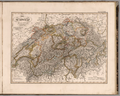
1834 Die Schweiz. (Switzerland). World Atlas No. XXXIV. Stieler's Hand-Atlas (No. 32) … |

1828 Jtalien. (Italy). World Atlas No. XXXV. Stieler's Hand-Atlas (No. 33). … |

1835 Galizien, Ungarn mit Slavonien und Croat … World Atlas No. XXXVIII. Stieler's Hand-Atlas (No. 3 … |