|
Author
[Brue, Adrien Hubert, 1786-1832, Picquet, C.]
Full Title
Carte generale de la Turquie d'Europe, de la Grece et des iles Ioniennes par A. Brue, Geographe du Roi. Revue et augmentee par Ch. Picquet, Geographe du Roi et de Mgr. le Duc d'Orleans. Paris, Chez Chles. Picquet, Quai Conti No. 17, pres du Pont des Arts, 1840.
Publisher
C. Picquet
Author
[Brue, Adrien Hubert, 1786-1832, Picquet, C.]
Full Title
Carte generale de la Grece moderne, de l'Archipel, de l'Albanie, de la Macedoine et de la Romelie. Redigee par A. Brue, Geographe du Roi. Revue et augmentee par Ch. Picquet, Geographe du Roi et de Mgr. le Duc d'Orleans. Paris, Chez Chles. Picquet, Quai Conti No. 17, pres du Pont des Arts, 1840.
Publisher
C. Picquet
Author
[Brue, Adrien Hubert, 1786-1832, Picquet, C.]
Full Title
Carte generale de l'Amerique Septentrionale, et des iles qui en dependent, par A. Brue, Geographe du Roi. Revue et augmentee par Ch. Picquet, Geographe du Roi et du Duc d'Orleans. Chez Chles. Picquet, Quai Conti No. 17, pres du Pont des Arts. A Paris, 1840.
Publisher
C. Picquet
Author
[Brue, Adrien Hubert, 1786-1832, Picquet, C.]
Full Title
Carte generale des Etats-Unis, des Haut et Bas-Canada, de la Nouvle. Ecosse, du Nouvau. Brunswick, de Terre-Neuve, &a. (with) Partie sud de la Floride. (with) Ile de Terre-Neuve. Seconde edition par A. Brue, Geographe du Roi. Revue et augmentee par Chles. Picquet, Geographe du Roi et du Duc d'Orleans. Quai Conti No. 17, pres du Pont des Arts. Paris, 1840.
Publisher
C. Picquet
Author
[Brue, Adrien Hubert, 1786-1832, Picquet, C.]
Full Title
Carte generale des Etats-Unis Mexicains, de la Republique du Texas et des etats de l'Amerique Centrale. (with) Guatemala ou Provinces-Unies de l'Amerique Centrale. Par A. Brue, Geographe du Roi (1825). Revue et augmentee par Ch. Picquet, Geographe du Roi et de Mgr. le Duc d'Orleans. Paris, 1840. Chez Ch. Picquet, Quai Conti No. 17, pres du Pont des Arts.
Publisher
C. Picquet
Author
[Brue, Adrien Hubert, 1786-1832, Picquet, C.]
Full Title
Carte generale de l'Empire d'Alexandre, par A. Brue, Geographe du Roi (1822). (with) Empire des Perses ... (with) Premier et deuxieme partages de l'Empire Macedonien ... (with) Troisieme et quatrieme partages de l'Empire Macedonien ... (with) Etat politique de l'Asie Mineure, et de la Hte. Asie apres la defaite d'Antiochus le Gd. A Magnesie ... Revue, completee et augmentee de cartes particulieres par Ch. Picquet, Geographe du Roi et de Mgr. le Duc d'Orleans. Paris, 1840. Chez Ch. Picquet, Quai Conti No. 17.
Publisher
C. Picquet
Author
[Brue, Adrien Hubert, 1786-1832, Picquet, C.]
Full Title
Carte generale de la Grece Ancienne, de la Macedoine, de la Thrace, &a.; redigee par A. Brue, Geographe du Roi, 1829. (with) Etats de la Grece pendant l'invasion Medique. (with) Etat de la Grece en 225 et en 216 av. J.C. (with) Colonies Grecques. (with) Athenes et ses environs. Revue, completee et augmentee de cartes particulieres par Ch. Picquet, Geographe du Roi et de Mgr. le Duc d'Orleans. Paris, 1840. Chez Ch. Picquet, Quai Conti No. 17, pres du Pont des Arts.
Publisher
C. Picquet
Author
Cooke, D.B & Co.
Full Title
(Covers to) D.B. Cooke & Co.'s Great Western Railway Guide. Exhibiting All Stations With Distances From Each other. Chicago, 1856. Entered ... 1856 by D.B. Cooke & Company. Middleton Wallace & Co. Lith. Cincinnati.
Publisher
Cooke, D.B & Co.
Author
Cooke, D.B & Co.
Full Title
D.B. Cooke & Co.'s Great Western Railway Guide. Exhibiting All Stations With Distances From Each other. Chicago, 1856. Entered ... 1856 by D.B. Cooke & Company. Middleton Wallace & Co. Lith. Cincinnati.
Publisher
Cooke, D.B & Co.
Author
Arrowsmith, Aaron Jr.
Full Title
Spain and Portugal. Re- Published by G.F. Cruchley, Mapseller, 81 Fleet Street. (to accompany) Outlines Of The World. By A. Arrowsmith, Hydrographer to His Majesty. 1850.
Publisher
G.F. Cruchley
Author
Arrowsmith, Aaron Jr.
Full Title
Switzerland. Re- Published, Jany st. 1845, by G.F. Cruchley, Mapseller, 81 Fleet Street, London. (to accompany) Outlines Of The World. By A. Arrowsmith, Hydrographer to His Majesty. 1850.
Publisher
G.F. Cruchley
Author
Stieler, Adolf
Full Title
No. III. Stieler's Hand-Atlas No. 5a. Der nordliche gestirnte Himmel. (The Northern Starry Sky).
Publisher
Justus Perthes
Author
[Wilkes, Charles, United States Exploring Expedition]
Full Title
Island of Natrai, Feejee (Fiji) Group, by U.S.Ex.Ex. 1840. Island of Angau (Gau or Koro), Feejee (Fiji) Group, by U.S.Ex.Ex. 1840.
Publisher
C. Sherman
Author
[Wilkes, Charles, United States Exploring Expedition]
Full Title
Island of Moala (Keteira), Feejee (Fiji) Group, by the U.S.Ex.Ex. 1840. Island of Totoia (Totoya), Feejee (Fiji) Group, by the U.S.Ex.Ex. 1840. Island of Matuku, Feejee (Fiji) Group, by the U.S.Ex.Ex. 1840.
Publisher
C. Sherman
Author
[Wilkes, Charles, United States Exploring Expedition]
Full Title
Island and Harbours of Mbenga, South Side of Viti Levu, Feejee (Fiji) Group, by the U.S.Ex.Ex. 1840. Rewa-Roads, South Side of Viti Levu, by the U.S.Ex.Ex. 1840.
Publisher
C. Sherman
Author
[Wilkes, Charles, United States Exploring Expedition]
Full Title
Eastern Group, Feejee (Fiji) Islands, by the U.S.Ex.Ex. 1840.
Publisher
C. Sherman
Author
[Wilkes, Charles, United States Exploring Expedition]
Full Title
Western End of Viti Levu, with the Ship Passages and Anchorages from Malolo Passage including the Neighboring Islands to Sakau Bay, Feejee (Fiji) Islands, by the U.S.Ex.Ex. 1840.
Publisher
C. Sherman
Author
[Wilkes, Charles, United States Exploring Expedition]
Full Title
Ports Orchard and Madison including the Inlets and Passages between them in Admiralty Inlet, Oregon Territory, by the U.S.Ex.Ex. 1840.
Publisher
C. Sherman
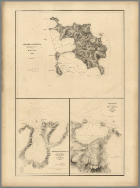
Author
[Wilkes, Charles, United States Exploring Expedition]
Full Title
Island of Yendua, Feejee (Fiji) Group, by the U.S.Ex.Ex. 1840. Nucumurry Harbour, West End of Vanua Levu, by the U.S.Ex.Ex. 1840. Wailea Bay, North Side of Vanua Levu, by the U.S.Ex.Ex. 1840.
Publisher
C. Sherman
Author
[Wilkes, Charles, United States Exploring Expedition]
Full Title
Channel on the South Western Side of Vanua Levu from Ivaca Peak to Savu Savu Bay, Feejee (Fiji) Islands by the U.S.Ex.Ex. 1840.
Publisher
C. Sherman
Author
[United States Exploring Expedition (1838-1842), Wilkes, Charles, 1798-1877]
Full Title
Chart of the Antarctic Continent Shewing the Icy Barrier Attached to it. Discovered by the U.S. Ex. Ex. Charles Wilkes Esq. Commander. 1840. Eng. by Sherman & Smith, N.Y.
Publisher
Lea & Blanchard
Author
[United States Exploring Expedition (1838-1842), Wilkes, Charles, 1798-1877]
Full Title
Chart of the Viti Group or Feejee Islands by the U.S. Ex. Ex. Charles Wilkes Esq. Commander. 1840. Eng. by Sherman & Smith, N.Y.
Publisher
Lea & Blanchard
Author
Stieler, Adolf
Full Title
No. III. Stieler's Hand-Atlas No. 5a. Der nordliche gestirnte Himmel. (The Northern Starry Sky).
Publisher
Justus Perthes
Author
[Paullin, Charles O., Wright, John K.]
Full Title
Plate 31. Cartography 1492-1867. Bonneville Map, 1837. Greenhow Map. 1840. Pike Map of Mississippi River, 1810. (Facsimiles).
Publisher
[Carnegie Institution of Washington, American Geographical Society of New York]
Author
[Grimm, J.L., Mahlmann, H.]
Full Title
Karte von Hoch-Asien zu C. Ritter's Erdkunde, Buch II, Asien, Th. 1 & 2. bearbeitat von J.L. Grimm, herausgegeben von C. Ritter und F.A. O'Etzel. Berlin, 1833 im Geogaphischen Verlags-Comtoir. (Map of High Asia).
Publisher
G. Reimer
Author
[Grimm, J.L., Mahlmann, H.]
Full Title
Karte von Hoch-Asien zu C. Ritter's Erdkunde, Buch II, Asien, Th. 1 & 2. bearbeitat von J.L. Grimm, herausgegeben von C. Ritter und F.A. O'Etzel. Berlin, 1833 im Geogaphischen Verlags-Comtoir. (Map of High Asia).
Publisher
G. Reimer
Author
[Grimm, J.L., Mahlmann, H.]
Full Title
China.
Publisher
G. Reimer
Author
[Grimm, J.L., Mahlmann, H.]
Full Title
West Siberien. (West Siberia).
Publisher
G. Reimer
Author
[Grimm, J.L., Mahlmann, H.]
Full Title
West Siberien. (West Siberia).
Publisher
G. Reimer
Author
[Grimm, J.L., Mahlmann, H.]
Full Title
Ost Siberien. Mongolei. Mandschire. (East Siberia. Mongolia. Manchuria).
Publisher
G. Reimer
Author
[Grimm, J.L., Mahlmann, H.]
Full Title
Das Himalaja Gebirg in Bissahir, Gherwal & Kemaun, vom Suedrande des Plateaus von Mittel-Tibet bis zum Tieflande von Hindostan ... Berlin, 1933. (The Himalayan mountains in Bissahir, Gherwal & Kemaun, from the southern edge of the plateau of Central Tibet to the low lands of Hindustan ... Berlin, 1933.)
Publisher
G. Reimer
Author
[Grimm, J.L., Mahlmann, H.]
Full Title
Uebersichts-Karte von Oest-Hoch-Asien ... Berlin. 1839. (Survey Map of East-High-Asia ... Berlin, 1839.)
Publisher
G. Reimer
Author
[Grimm, J.L., Mahlmann, H.]
Full Title
Karte vom Russischen Altai ... Berlin, 1839. (Map of Russian Altai ... Berlin, 1839).
Publisher
G. Reimer
Author
[Grimm, J.L., Mahlmann, H.]
Full Title
(Geologic Cross-Section) (Profiles of Asian Mountains).
Publisher
G. Reimer
Author
[Grimm, J.L., Mahlmann, H.]
Full Title
(Sheet I) Karte Inner-Asiens ... Berlin 1841. (Map of Inner-Asia.)
Publisher
G. Reimer
Author
[Grimm, J.L., Mahlmann, H.]
Full Title
(Sheet II) Karte Inner-Asiens ... Berlin 1841. (Map of Inner-Asia.)
Publisher
G. Reimer
Author
[Grimm, J.L., Mahlmann, H.]
Full Title
(Sheet III) Karte Inner-Asiens ... Berlin 1841. (Map of Inner-Asia.)
Publisher
G. Reimer
Author
[Grimm, J.L., Mahlmann, H.]
Full Title
(Sheet IV) Karte Inner-Asiens ... Berlin 1841. (Map of Inner-Asia.)
Publisher
G. Reimer
Author
[Grimm, J.L., Mahlmann, H.]
Full Title
(Composite Map) Karte Inner-Asiens ... Berlin 1841. (Map of Inner-Asia.)
Publisher
G. Reimer
Author
[Grimm, J.L., Mahlmann, H.]
Full Title
Versuch einer Darsellung von Sued Iran. (South Iran).
Publisher
G. Reimer
Author
[Grimm, J.L., Mahlmann, H., Zimmermann, Carl]
Full Title
(Index Map and Sectional Title Page) Atlas von Palaestina und der Sinai-Halbinsel zu C. Ritters Erdkunde Band XIV-XVI, 15 Blaetter im Maasstabe von 1:333333. IVtes Heft des Atlas von Vorder-Asien, 1ste Haelfte. Berlin 1850. (Atlas of Palestine and the Sinai Peninsula. 4th Issue, Atlas of Western Asia, 1st half.)
Publisher
G. Reimer
Author
[Grimm, J.L., Mahlmann, H.]
Full Title
Sect. I. Beirut. (Atlas von Palaestina und der Sinai-Halbinsel. (Atlas of Palestine and the Sinai Peninsula)).
Publisher
G. Reimer
Author
[Grimm, J.L., Mahlmann, H.]
Full Title
Sect. II. Damascus. (Atlas von Palaestina und der Sinai-Halbinsel. (Atlas of Palestine and the Sinai Peninsula)).
Publisher
G. Reimer
Author
[Grimm, J.L., Mahlmann, H.]
Full Title
Sect. III. Tiberias. (Atlas von Palaestina und der Sinai-Halbinsel. (Atlas of Palestine and the Sinai Peninsula)).
Publisher
G. Reimer
Author
[Grimm, J.L., Mahlmann, H.]
Full Title
Sect. IV. El Mezareib. (Atlas von Palaestina und der Sinai-Halbinsel. (Atlas of Palestine and the Sinai Peninsula)).
Publisher
G. Reimer
Author
[Grimm, J.L., Mahlmann, H.]
Full Title
Sect. V. Jerusalem. (Atlas von Palaestina und der Sinai-Halbinsel. (Atlas of Palestine and the Sinai Peninsula)).
Publisher
G. Reimer
Author
[Grimm, J.L., Mahlmann, H.]
Full Title
Sect. VI. Kulat Zerka. (Atlas von Palaestina und der Sinai-Halbinsel. (Atlas of Palestine and the Sinai Peninsula)).
Publisher
G. Reimer
Author
[Grimm, J.L., Mahlmann, H.]
Full Title
Sect. VII. El Khulil (Hebron). (Atlas von Palaestina und der Sinai-Halbinsel. (Atlas of Palestine and the Sinai Peninsula)).
Publisher
G. Reimer
Author
[Grimm, J.L., Mahlmann, H.]
Full Title
Sect. VIII. Todtes Meer. (Atlas von Palaestina und der Sinai-Halbinsel. (Atlas of Palestine and the Sinai Peninsula)).
Publisher
G. Reimer
|