Who What Where WhenREMOVEWHERE
|
Author
Woerl, Joseph Edmund
Full Title
Das Koenigreich Preussen. (Prussian Empire).
Publisher
B. Herder
Author
Woerl, Joseph Edmund
Full Title
Die Schweiz. (Switzerland).
Publisher
B. Herder
Author
Woerl, Joseph Edmund
Full Title
Italien. (Italy).
Publisher
B. Herder
Author
Woerl, Joseph Edmund
Full Title
Das Koenigrreich Daenmark. (Kingdom of Denmark).
Publisher
B. Herder
Author
Woerl, Joseph Edmund
Full Title
Die Scandivanische Halb-Insel: Schweden und Norwegen. (Scandinavia: Sweden and Norway).
Publisher
B. Herder
Author
Woerl, Joseph Edmund
Full Title
Russland: Europaeischen Antheils. (Russia in Europe).
Publisher
B. Herder
Author
Woerl, Joseph Edmund
Full Title
Die Europaeische Tuerkey. (Turkey in Europe).
Publisher
B. Herder
Author
Woerl, Joseph Edmund
Full Title
Nord-Amerika. (North America).
Publisher
B. Herder
Author
Woerl, Joseph Edmund
Full Title
Vereinigte Staaten von Nord-Amerika. (United States).
Publisher
B. Herder
Author
Woerl, Joseph Edmund
Full Title
West-Indien und Central Amerika. (West Indies and Central America).
Publisher
B. Herder
Author
Woerl, Joseph Edmund
Full Title
Sud-Amerika. (South America).
Publisher
B. Herder
Author
Woerl, Joseph Edmund
Full Title
Asien (Asia).
Publisher
B. Herder
Author
Woerl, Joseph Edmund
Full Title
Ozeanien. Australien. Polynesien. (Oceania. Australia. Polynesia).
Publisher
B. Herder
Author
Woerl, Joseph Edmund
Full Title
Palaestina. (Palestine). (inset) Arabia Petraea. Plan von Jerusalem.
Publisher
B. Herder
Author
Mitchell, Samuel Augustus
Full Title
Mitchell's National Map of the American Republic Or United States Of North America. Together with Maps of the Vicinities Of Thirty-Two Of The Principal Cities And Towns in the Union. Published by S. Augustus Mitchell Philadelphia. 1843. No. 8-1/2 South Seventh Street. Drawn by J.H. Young. Engraved by J.H. Brightly. Entered ... 1842, by S. Augustus Mitchell ... Pennsylvania. (inset) Map Of the Southern Part Of Florida. (inset) Map Of The North-Eastern Boundary Of The United States ... (bordered by 32 additional inset vicinity maps of cities).
Publisher
S. Augustus Mitchell
Author
Anson, W.
Full Title
(Covers to) Map Of Maine Constructed from the most Correct Surveys With Sectional Distances and Elevations or Level, of the St. Croix River from Calais Bridge. Deduced from the States Survey, Made by W. Anson, Civil Engineer, In 1836. Engraved & Published by by S.H. Colesworthy, Portland. 1843. Revised Edition.
Publisher
S.H. Colesworthy
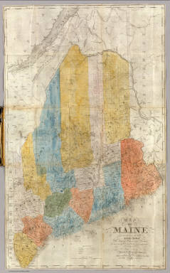
Author
Anson, W.
Full Title
Map Of Maine Constructed from the most Correct Surveys With Sectional Distances and Elevations or Level, of the St. Croix River from Calais Bridge. Deduced from the States Survey, Made by W. Anson, Civil Engineer, In 1836. Engraved & Published by by S.H. Colesworthy, Portland. 1843. Revised Edition.
Publisher
S.H. Colesworthy
Author
Berghaus, Heinrich
Full Title
Vermischtes zur Hydrographie: Schwankungen des Ostsee Standes, Strom Neigungen, &c. &c. 2te Abtheilung: Hydrographie, No. 10. Potsdam, gez. u. gest. in der geogr. Kunstschule. Gotha, bei Justus Perthes. 1843.
Publisher
Justus Perthes
Author
Berghaus, Heinrich
Full Title
Europa in Geologischer Beziehung nach den Hauptmassen der Gebirgs-Formationen. 3te Abtheilung: Geologie, No. 4. Gotha, bei J. Perthes. 1843.
Publisher
Justus Perthes
Author
Berghaus, Heinrich
Full Title
Karte von Sud-Amerika zur Ubersicht der Unebenheiten des Bodens. 3te Abtheilung: Geologie, No. 5. Potsdam, gez. u. gest. in der geogr. Kunstschule. Gotha, bei Justus Perthes, 1843.
Publisher
Justus Perthes
Author
Berghaus, Heinrich
Full Title
Geologische Karte von Deutschland und den anlieg. Landern nach des Bergmeister's H. Credner Zusamenstellung. 1843. 3te Abtheilung: Geologie, No. 12. Gotha, bei J. Perthes.
Publisher
Justus Perthes
Author
Berghaus, Heinrich
Full Title
Spezial-Karte vom Riesen-Gebirge. 3te Abtheilung: Geologie, No. 13. Gezeichnet u. gestochen in der geogr. Kunstschule zu Potsdam. Gotha, J. Perthes, 1843.
Publisher
Justus Perthes
Author
Radefeld, Carl Christian Franz, 1788-1874
Full Title
Neueste Karte von Europa entworfen und gezeichnet von Hptm. Radefeld 1843. Stahlstich, Direction v. Kleinknecht, aus der Schweinfurter Geographischen Graviranstalt des Bibliographischen Instituts zu Hildburghausen, Amsterdam, Paris u. Philadelphia, (1860)
Publisher
Bibliographischen Instituts
Author
Meyer, Joseph, 1796-1856
Full Title
Neueste Karte von Spanien und Portugal 1843. (with) Lissabon. (with) Madrid. Aus der Geographischen Graviranstalt des Bibliographischen Instituts zu Hildburghausen, Amsterdam, Paris u. Philadelphia, (1860)
Publisher
Bibliographischen Instituts
Author
Society for the Diffusion of Useful Knowledge (Great Britain)
Full Title
China. Engraved by J. & C. Walker. Published for the Society for the Diffusion of Useful Knowledge by Chapman & Hall, 186 Strand, October 1, 1843. (1844)
Publisher
Chapman and Hall
Author
Society for the Diffusion of Useful Knowledge (Great Britain)
Full Title
North America. Published under the superintendence of the Society for the Diffusion of Useful Knowledge. Engraved by J. & C. Walker. Published by Chapman & Hall, 186 Strand, Feby. 25th. 1843. (1844)
Publisher
Chapman and Hall
Author
Society for the Diffusion of Useful Knowledge (Great Britain)
Full Title
London. 1843. Drawn & engraved from authentic documents & personal observation by B.R. Davies, 16 George Street, Euston Square. London, published Nov. 1, 1843 under the superintendence of the Society for the Diffusion of Useful Knowledge, by Chapman & Hall, 186 Strand (1844)
Publisher
Chapman and Hall
Author
Radefeld, Carl Christian Franz, 1788-1874
Full Title
Neueste Karte von Centralamerica und West Indien, 1843. Entworf. u. gezeichn. v. Hauptm. Radefeld. (with) Der Isthmus von Panama. Loyds Aufnahme v. J. 1829. Stahlstich, Direction v. Kleinknecht, aus der Schweinfurter Geographischen Graviranstalt des Bibliographischen Instituts zu Hildburghausen, Amsterdam, Paris und Philadelphia, (1860)
Publisher
Bibliographischen Instituts
Author
Radefeld, Carl Christian Franz, 1788-1874
Full Title
Neueste Karte von Salzburg. Entw. u. gez. v. Hauptm. Radefeld. 1843. Stahlstich, Direction v. Kleinknecht, aus der Schweinfurter Geographischen Graviranstalt des Bibliographischen Instituts zu Hildburghausen, Amsterdam, Paris und Philadelphia, (1860)
Publisher
Bibliographischen Instituts
Author
Meyer, Joseph, 1796-1856
Full Title
Neueste Karte von Siebenburgen. Nach den besten Quellen entworf. u. gezeichn. von Hauptm. Radefeld. 1843. Verlag des Bibliographischen Instituts zu Hildburghausen, Amsterdam, Paris u. Philadelphia, (1860)
Publisher
Bibliographischen Instituts
Author
Radefeld, Carl Christian Franz, 1788-1874
Full Title
Neueste Karte von America. Nach den bessten Quellen entworf u. gezeich. vom Hauptm. Radefeld. 1843. Stahlstich, Direction v. Kleinknecht aus der Schweinfurter Geographischen Graviranstalt des Bibliograph. Instituts zu Hildburghausen, Amsterdam, Paris und Philadelphia, (1860)
Publisher
Bibliographischen Instituts
Author
Marzolla, Benedetto
Full Title
Carta generale del mondo conosciuto dagli antichi. Napoli 1843. Reale Litografia Militare, Benedetto Marzolla, impiegato nel Rle. Officio Topografico esgui col pennello su pietra.
Publisher
B. Marzolla
Author
Marzolla, Benedetto
Full Title
Descrizione del globo in due emisferi nella quale sono indicate tutte le scoperte finora fatte, compilata, ed eseguita col pennello su pietra da Benedetto Marzolla, 1843. Napoli, Reale Litografia Militare.
Publisher
B. Marzolla
Author
Marzolla, Benedetto
Full Title
Carta generale di Affrica. Benedetto Marzolla esegui col pennello su pietra, Napoli 1843.
Publisher
B. Marzolla
Author
Marzolla, Benedetto
Full Title
Egitto ed Arabia Petrea. Benedetto Marzolla esegui, 1843.
Publisher
B. Marzolla
Author
Delamarche, Felix.
Full Title
L'Empire Romai et les Barbares du Nord au IVeme Siecle ...1843.
Publisher
F. Delamarche
Author
Delamarche, Felix.
Full Title
Carte de L'Empire Carlovingien et des Empires Arabes ... 1843. (inset) Partage de L'Empire Carlovingies.
Publisher
F. Delamarche
Author
Delamarche, Felix.
Full Title
Carte de la Suisse ou Helvetie ... 1843.
Publisher
F. Delamarche
Author
Delamarche, Felix.
Full Title
Carte de L'Afrique ... 1843. (inset) Carte de L'Egypte, de la Nubie de L'Abissinie, du Kordofan et du Barfour.
Publisher
F. Delamarche
Author
[Morse, Sidney E., Breese, S.]
Full Title
(Covers to) Supplement To The New-York Observer. The Cerographic Atlas Of The United States. (No.2). By Sidney E. Morse, A.M. And Samuel Breese, A.M. New-York: Published By Sidney E. Morse & Co. 1843.
Publisher
Sidney E. Morse & Co.
Author
[Morse, Sidney E., Breese, S.]
Full Title
City of New York 1843. Entered ... 1842, by Sidney E. Morse and Samuel Breese ... New-York. (to accompany) Supplement To The New-York Observer. The Cerographic Atlas Of The United States. By Sidney E. Morse, A.M. And Samuel Breese, A.M. New-York: Published By Sidney E. Morse & Co. 1843.
Publisher
Sidney E. Morse & Co.
Author
[Morse, Sidney E., Breese, S.]
Full Title
Pennsylvania. (to accompany) Supplement To The New-York Observer. The Cerographic Atlas Of The United States. No.3. 1845. Entered ... 1843, by Sidney E. Morse and Samuel Breese ... New-York. (insets) Philadelphia, Montgomery and Delaware Counties. Coal Region.
Publisher
Sidney E. Morse & Co.
Author
[Morse, Sidney E., Breese, S.]
Full Title
North Carolina. (to accompany) Supplement To The New-York Observer. The Cerographic Atlas Of The United States. No.3. 1845. Entered ... 1843, by Sidney E. Morse and Samuel Breese ... New-York.
Publisher
Sidney E. Morse & Co.
Author
[Morse, Sidney E., Breese, S.]
Full Title
South Carolina. (to accompany) Supplement To The New-York Observer. The Cerographic Atlas Of The United States. No.3. 1845. Entered ... 1843, by Sidney E. Morse and Samuel Breese ... New-York.
Publisher
Sidney E. Morse & Co.
Author
[Morse, Sidney E., Breese, S.]
Full Title
Indiana. (to accompany) Supplement To The New-York Observer. The Cerographic Atlas Of The United States. No.3. 1845. Entered ... 1843, by Sidney E. Morse and Samuel Breese ... New-York.
Publisher
Sidney E. Morse & Co.
Author
[Murchison, Roderick Impey, Sir, 1792-1871, Society for the Diffusion of Useful Knowledge (Great Britain)]
Full Title
Geological map of England and Wales. Published under the superintendence of the Society for the Diffusion of Useful Knowledge. 1843. Arranged by Roderick Impey Murchison ... S.P. Woodward del. Col(oure)d. by T. Malby. J. & C. Walker sculpt. Published by Chapman & Hall 186 Strand Decr. 15th. 1843. (1844)
Publisher
Chapman and Hall
Author
Society for the Diffusion of Useful Knowledge (Great Britain)
Full Title
The Netherlands, de Nederlanden, and Belgium, La Belgique. Published for the Society for the Diffusion of Useful Knowledge, by Chapman & Hall, 186 Strand, October 1, 1843. J & C. Walker sculpt. (1844)
Publisher
Chapman and Hall
Author
Society for the Diffusion of Useful Knowledge (Great Britain)
Full Title
The Turkish Empire in Europe and Asia with the Kingdom of Greece. Engraved by J. & C. Walker. Published by the Society for the Diffusion of Useful Knowledge, 42 Bedford Sqre. Octr. 15th. 1843. (London: Chapman & Hall, 1844)
Publisher
Chapman and Hall
Author
[Smith, William, Sir, 1813-1893, Society for the Diffusion of Useful Knowledge (Great Britain)]
Full Title
Grecian Archipelago, ancient, by William Smith L.L.D. Published under the superintendence of the Society for the Diffusion of Useful Knowledge. Engraved by J. & C. Walker. Published by Chapman & Hall 186 Strand April 1st. 1843 (1844)
Publisher
Chapman and Hall
|