|   
                     
                     1852


                     Spanien, Portugal.


                     School Atlas


                     Spanien und Portugal. (Efter Stielers Ha
                     
                    | 
      
        |   
                     
                     1852


                     SO Deutschland, Oesterreich. Lande.


                     School Atlas


                     Sud-ostliches Deutschland, enthalt die O
                     
                    | 
      
        |   
                     
                     1852


                     Schweiz, Liechtenstein.


                     School Atlas


                     Die Schweiz und das Furstenthum Liechten
                     
                    | 
      
        |   
                     
                     1852


                     Preussen, Posen, Polen, Krakau.


                     School Atlas


                     Preuss. Provinzen, Preussen u. Posen, Kg
                     
                    | 
      
        |   
                     
                     1852


                     Galizien, Ungarn, Slavonien, Kroatien, S


                     School Atlas


                     Galizien, Ungarn, Slavonien und Kroatien
                     
                    | 
      
        |   
                     
                     1852


                     Daenemark, Schleswig, Holstein, Lauenbur


                     School Atlas


                     Daenemark mit Schleswig, Holstein und La
                     
                    | 
      
        |   
                     
                     1852


                     Schweden, Norwegen, Finnland.


                     School Atlas


                     Schweden, Norwegen und Finnland. (Efter 
                     
                    | 
      
        |   
                     
                     1852


                     Europaeisches Russland.


                     School Atlas


                     Europaeisches Russland. (Efter Stielers 
                     
                    | 
      
        |   
                     
                     1852


                     Osmanischen Reichs europ. Theil, Grieche


                     School Atlas


                     Des Osmanischen Reichs, europaeischer Th
                     
                    | 
      
        |   
                     
                     1852


                     Map of the Great Salt Lake.


                     Exploration Book


                     Map of the Great Salt Lake And Adjacent 
                     
                    | 
      
        |   
                     
                     1852


                     Map of a Reconnoissance between Fort Lea


                     Exploration Book


                     Map of a Reconnoissance between Fort Lea
                     
                    | 
      
        |   
                     
                     1852


                     Cover: Exploration & Survey, Valley of t


                     Exploration Book


                     (Covers to maps of the) Exploration and 
                     
                    | 
      
        |   
                     
                     1852


                     Title Page: Exploration and survey of th


                     Exploration Book


                     (Title Page to) Exploration and Survey o
                     
                    | 
      
        |   
                     
                     1852


                     Sheet 1: Plan of York, 1852


                     [City Atlas, Survey Map]


                     Sheet 1: York. Surveyed in 1850, by Capt
                     
                    | 
      
        |   
                     
                     1852


                     Sheet 2: Plan of York, 1852


                     [City Atlas, Survey Map]


                     Sheet 2: York. Surveyed in 1850, by Capt
                     
                    | 
      
        |   
                     
                     1852


                     Sheet 3: Plan of York, 1852


                     [Survey Map, City Atlas]


                     Sheet 3: York. Surveyed in 1850, by Capt
                     
                    | 
      
        |   
                     
                     1852


                     Sheet 4: Plan of York, 1852


                     [Survey Map, City Atlas]


                     Sheet 4: York. Surveyed in 1850, by Capt
                     
                    | 
      
        |   
                     
                     1852


                     Sheet 5: Plan of York, 1852


                     [Survey Map, City Atlas]


                     Sheet 5: York. Surveyed in 1850, by Capt
                     
                    | 
      
        |   
                     
                     1852


                     Sheet 6: Plan of York, 1852


                     [Survey Map, City Atlas]


                     Sheet 6: York. Surveyed in 1850, by Capt
                     
                    | 
      
        |   
                     
                     1852


                     Sheet 7: Plan of York, 1852


                     [City Atlas, Survey Map]


                     Sheet 7: York. Surveyed in 1850, by Capt
                     
                    | 
      
        |   
                     
                     1852


                     Sheet 8: Plan of York, 1852


                     [Survey Map, City Atlas]


                     Sheet 8: York. Surveyed in 1850, by Capt
                     
                    | 
      
        |   
                     
                     1852


                     Sheet 9: Plan of York, 1852


                     [City Atlas, Survey Map]


                     Sheet 9: York. Surveyed in 1850, by Capt
                     
                    | 
      
        |   
                     
                     1852


                     Sheet 10: Plan of York, 1852


                     [Survey Map, City Atlas]


                     Sheet 10: York. Surveyed in 1850, by Cap
                     
                    | 
      
        |   
                     
                     1852


                     Sheet 11: Plan of York, 1852


                     [City Atlas, Survey Map]


                     Sheet 11: York. Surveyed in 1850, by Cap
                     
                    | 
      
        |   
                     
                     1852


                     Sheet 12: Plan of York, 1852


                     [Survey Map, City Atlas]


                     Sheet 12: York. Surveyed in 1850, by Cap
                     
                    | 
      
        |   
                     
                     1852


                     Sheet 13: Plan of York, 1852


                     [City Atlas, Survey Map]


                     Sheet 13: York. Surveyed in 1850, by Cap
                     
                    | 
      
        |   
                     
                     1852


                     Sheet 14: Plan of York, 1852


                     [Survey Map, City Atlas]


                     Sheet 14: York. Surveyed in 1850, by Cap
                     
                    | 
      
        |   
                     
                     1852


                     Sheet 15: Plan of York, 1852


                     [Survey Map, City Atlas]


                     Sheet 15: York. Surveyed in 1850, by Cap
                     
                    | 
      
        |   
                     
                     1852


                     Sheet 16: Plan of York, 1852


                     [Survey Map, City Atlas]


                     Sheet 16: York. Surveyed in 1850, by Cap
                     
                    | 
      
        |   
                     
                     1852


                     Sheet 17: Plan of York, 1852


                     [Survey Map, City Atlas]


                     Sheet 17: York. Surveyed in 1850, by Cap
                     
                    | 
      
        |   
                     
                     1852


                     Sheet 18: Plan of York, 1852


                     [Survey Map, City Atlas]


                     Sheet 18: York. Surveyed in 1850, by Cap
                     
                    | 
      
        |   
                     
                     1852


                     Sheet 19: Plan of York, 1852


                     [Survey Map, City Atlas]


                     Sheet 19: York. Surveyed in 1850, by Cap
                     
                    | 
      
        |   
                     
                     1852


                     Sheet 20: Plan of York, 1852


                     [Survey Map, City Atlas]


                     Sheet 20: York. Surveyed in 1850, by Cap
                     
                    | 
      
        |   
                     
                     1852


                     Sheet 21: Plan of York, 1852


                     [City Atlas, Survey Map]


                     Sheet 21: York. Surveyed in 1850, by Cap
                     
                    | 
      
        |   
                     
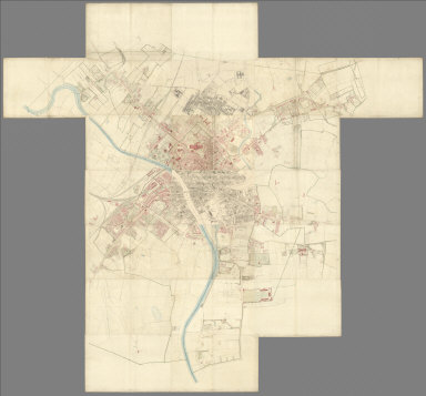
                     1852


                     Composite: Sheets 1 - 21, Plan of York, 


                     [City Atlas, Survey Map]


                     (Composite to) (Sheets 1 - 21) York. Sur
                     
                    | 
      
        |   
                     
                     1852


                     San Pablo Bay, Carquines Straits.


                     Chart Map


                     Chart of the Bay of San Pablo Straits Of
                     
                    | 
      
        |   
                     
                     1852


                     View, San Francisco from Yerba Buena Isl


                     Chart Map


                     View of San Francisco from Yerba Buena I
                     
                    | 
      
        |   
                     
                     1852


                     Entrance, San Francisco.


                     Chart Map


                     Entrance to San Francisco. C. Ringgold, 
                     
                    | 
      
        |   
                     
                     1852


                     View, Sacramento City.


                     Chart Map


                     View of Sacramento City from the west ba
                     
                    | 
      
        |   
                     
                     1852


                     View, Benicia.


                     Chart Map


                     View of Benicia from the anchorage east 
                     
                    | 
      
        |   
                     
                     1852


                     Views, Mt. Diablo.


                     Chart Map


                     View of Monte Diablo from Garnet Island.
                     
                    | 
      
        |   
                     
                     1852


                     Invincible buoy, Angel I., Marin Is.


                     Chart Map


                     Mark for Invincible buoy, Point Smith, e
                     
                    | 
      
        |   
                     
                     1852


                     Tongue Shoal, Sacramento R. entrance.


                     Chart Map


                     Mark for Tongue Shoal. Entrance to the S
                     
                    | 
      
        |   
                     
                     1852


                     Marks, Sacramento R. entering.


                     Chart Map


                     Marks for entering the Sacramento and it
                     
                    | 
      
        |   
                     
                     1852


                     General chart, San Francisco Bay.


                     Chart Map


                     General chart embracing surveys of the F
                     
                    | 
      
        |   
                     
                     1852


                     Farallones, San Francisco Bay.


                     Chart Map


                     Chart of the Farallones and entrance to 
                     
                    | 
      
        |   
                     
                     1852


                     Suisun, Vallejo bays.


                     Chart Map


                     Chart of Suisun & Vallejo bays with the 
                     
                    | 
      
        |   
                     
                     1852


                     Sacramento River.


                     Chart Map


                     Chart of the Sacramento River from Suisu
                     
                    | 
      
        |   
                     
                     1852


                     Carquines Straits, Vallejo Bay, other an


                     Chart Map


                     Straits of Carquines and Vallejo Bay by 
                     
                    | 
      
        |   
                     
                     1852


                     Cover: Series of charts, sailing directi


                     Chart Map


                     (Covers to) A Series of charts, with sai
                     
                    |