Who What Where WhenREMOVEWHATShow MoreWHERE
|
Author
Radefeld, Carl Christian Franz, 1788-1874
Full Title
Konigreich Bayern Ites Blatt. Entw. u. gez. v. Major C. Radefeld, (1858). (with Umgebung von Bamberg). (with Umgebung von Furth und Nurnberg. Stich, Druck und Verlag des Bibliographischen Instituts in Hildburghausen, 1860)
Publisher
Bibliographischen Instituts
Author
Radefeld, Carl Christian Franz, 1788-1874
Full Title
Konigreich Bayern IIItes Blatt. Entw. u. gez. v. Major C. Radefeld, (1858). Gest. v. Th. Macht. (with) Plan von Munchen. (with Umgebung von Augsburg. Stich, Druck und Verlag des Bibliographischen Instituts in Hildburghausen, 1860)
Publisher
Bibliographischen Instituts
Author
[Bavaria (Kingdom). Heer. Generalstab. Topographisches Bureau., Meyer, Joseph, 1796-1856, Radefeld, Carl Christian Franz, 1788-1874]
Full Title
Das Konigreich Bayern desseitz des Rheins, nach den topographischen Karten des Konigl. Bayr. Generalquartiermeisterstabes vom Jahr 1853, entw. u gezeichnet in IV Blatter vom Major C. Radefeld, 1858. IItes Blatt. Gest. v. W. Feuerstein. (with) Wurzburg. (with Umgebung von Regensburg). Stich, Druck und Verlag des Bibliographischen Instituts in Hildburghausen, (1860)
Publisher
Bibliographischen Instituts
Author
[James, Henry, 1803-1877, Clarke, Alexander Ross, 1828-1914]
Full Title
(Frontispiece to) Geometrical projection of two thirds of the sphere by Lieutt. Colonel H. James, R.E. F.R.S. M.R.I.A., &c. ... Engraved at the Ordnance Map Office Southampton, 1857 from a reduction made by photography. (with 2 insets) (to accompany) (V. 2: plates) Ordnance Trigonometrical Survey. Account of Principal Triangulation. Plates. (with) (V.1: text) Ordnance trigonometrical survey of Great Britain and Ireland : Account of the observations and calculations of the principal triangulation ... London: Printed by George Edward Eyre, and William Spottiswoode. Printers to the Queens most excellent Majesty. 1858.
Publisher
[George Edward Eyre and William Spottiswoode, Ordnance Survey Map Office]
Author
[James, Henry, 1803-1877, Clarke, Alexander Ross, 1828-1914]
Full Title
Ordnance Survey: Base apparatus. Plate II. Drawn and engraved in outline by J. Bradley. Finished by J.C. Peake at the Ordnance Survey Map Office, Southampton, March 1847. (to accompany) (V. 2: plates) Ordnance Trigonometrical Survey. Account of Principal Triangulation. Plates. (with) (V.1: text) Ordnance trigonometrical survey of Great Britain and Ireland : Account of the observations and calculations of the principal triangulation ... London: Printed by George Edward Eyre, and William Spottiswoode. Printers to the Queens most excellent Majesty. 1858.
Publisher
[George Edward Eyre and William Spottiswoode, Ordnance Survey Map Office]
Author
[Geological Survey of Great Britain and Ireland, Great Britain, Ordnance Survey Office]
Full Title
82. Chesterfield, SE Quad.
Publisher
Ordnance Map Office
Author
[Great Britain. Ordnance Survey, Mudge, William (1762-1820), Colby, Thomas, Baker, Benjamin, Great Britain. Board of Ordnance]
Full Title
2. Sheerness.
Publisher
[W. Mudge; Ordnance Survey, Thomas Colby (1784-1852)]
Author
[Great Britain. Ordnance Survey, Mudge, William (1762-1820), Colby, Thomas, Baker, Benjamin, Great Britain. Board of Ordnance]
Full Title
4. Denge Ness.
Publisher
[W. Mudge; Ordnance Survey, Thomas Colby (1784-1852)]
Author
[Great Britain. Ordnance Survey, Mudge, William (1762-1820), Colby, Thomas, Baker, Benjamin, Great Britain. Board of Ordnance]
Full Title
11. Winchester.
Publisher
[W. Mudge; Ordnance Survey, Thomas Colby (1784-1852)]
Author
[Great Britain. Ordnance Survey, Mudge, William (1762-1820), Colby, Thomas, Baker, Benjamin, Great Britain. Board of Ordnance]
Full Title
16. Poole.
Publisher
[W. Mudge; Ordnance Survey, Thomas Colby (1784-1852)]
Author
[Great Britain. Ordnance Survey, Mudge, William (1762-1820), Colby, Thomas, Baker, Benjamin, Great Britain. Board of Ordnance]
Full Title
20. Bridgewater.
Publisher
[W. Mudge; Ordnance Survey, Thomas Colby (1784-1852)]
Author
[Great Britain. Ordnance Survey, Mudge, William (1762-1820), Colby, Thomas, Baker, Benjamin, Great Britain. Board of Ordnance]
Full Title
25. Tavistock.
Publisher
[W. Mudge; Ordnance Survey, Thomas Colby (1784-1852)]
Author
[Great Britain. Ordnance Survey, Mudge, William (1762-1820), Colby, Thomas, Baker, Benjamin, Great Britain. Board of Ordnance]
Full Title
28. Lundy Island.
Publisher
[W. Mudge; Ordnance Survey, Thomas Colby (1784-1852)]
Author
[Great Britain. Ordnance Survey, Mudge, William (1762-1820), Colby, Thomas, Baker, Benjamin, Great Britain. Board of Ordnance]
Full Title
33. Penzance.
Publisher
[W. Mudge; Ordnance Survey, Thomas Colby (1784-1852)]
Author
[Great Britain. Ordnance Survey, Mudge, William (1762-1820), Colby, Thomas, Baker, Benjamin, Great Britain. Board of Ordnance]
Full Title
34. Cirencester.
Publisher
[W. Mudge; Ordnance Survey, Thomas Colby (1784-1852)]
Author
[Great Britain. Ordnance Survey, Mudge, William (1762-1820), Colby, Thomas, Baker, Benjamin, Great Britain. Board of Ordnance]
Full Title
38. Pembroke.
Publisher
[W. Mudge; Ordnance Survey, Thomas Colby (1784-1852)]
Author
[Great Britain. Ordnance Survey, Mudge, William (1762-1820), Colby, Thomas, Baker, Benjamin, Great Britain. Board of Ordnance]
Full Title
47. Dunmow.
Publisher
[W. Mudge; Ordnance Survey, Thomas Colby (1784-1852)]
Author
[Great Britain. Ordnance Survey, Mudge, William (1762-1820), Colby, Thomas, Baker, Benjamin, Great Britain. Board of Ordnance]
Full Title
56. Radnor.
Publisher
[W. Mudge; Ordnance Survey, Thomas Colby (1784-1852)]
Author
[Great Britain. Ordnance Survey, Mudge, William (1762-1820), Colby, Thomas, Baker, Benjamin, Great Britain. Board of Ordnance]
Full Title
70. Sleaford.
Publisher
[W. Mudge; Ordnance Survey, Thomas Colby (1784-1852)]
Author
[Great Britain. Ordnance Survey, Mudge, William (1762-1820), Colby, Thomas, Baker, Benjamin, Great Britain. Board of Ordnance]
Full Title
83. Lincoln.
Publisher
[W. Mudge; Ordnance Survey, Thomas Colby (1784-1852)]
Author
[James, Henry, 1803-1877, Clarke, Alexander Ross, 1828-1914]
Full Title
Ordnance Survey: Base apparatus. Plate III. Drawn and engraved by J.C. Peake at the Ordnance Survey Map Office, Southampton, March 1847. (to accompany) (V. 2: plates) Ordnance Trigonometrical Survey. Account of Principal Triangulation. Plates. (with) (V.1: text) Ordnance trigonometrical survey of Great Britain and Ireland : Account of the observations and calculations of the principal triangulation ... London: Printed by George Edward Eyre, and William Spottiswoode. Printers to the Queens most excellent Majesty. 1858.
Publisher
[George Edward Eyre and William Spottiswoode, Ordnance Survey Map Office]
Author
Campbell, Albert
Full Title
Preliminary Map of the Central Division Ft. Kearney South Pass & Honey Lake Wagon-Road. Surveyed and worked under the Direction of F.W. Lander, Supt. by W.H. Wagner, Engr. 1857-58. T.S. Wagner's Lith. Philada. Department of the Interior, Pacific Wagon Roads. (Sen. Ex. Doc. No. 36. Ho. Ex. Doc. No. 108 - 2nd Sess. 35 Cong.)
Publisher
T.S. Wagner's Lith.
Author
Campbell, Albert
Full Title
Map No. 1 of the El Paso & Fort Yuma Wagon Road. J.B. Leach, Superintendent. Made under the direction of N.H. Hutton, Chief Engr. Assisted by G.C. Wharton, Prinl. Asst. Engr. W.D. Cress and P.G. Hume, Assts. 1857-8. Thos. S. Wagner Lith. 38 Hudson St. Philada. Dept. of the Interior, Pacific Wagon Roads. (Sen. Ex. Doc. No. 36. Ho. Ex. Doc. No. 108 - 2nd Sess. 35 Cong.)
Publisher
T.S. Wagner's Lith.
Author
Campbell, Albert
Full Title
Map No. 2 of the El Paso & Fort Yuma Wagon Road. J.B. Leach, Superintendent. Made under the direction of N.H. Hutton, Chief Engr. Assisted by G.C. Wharton, Prinl. Asst. Engr. W.D. Cress and P.G. Hume, Assts. 1857-8. Thos. S. Wagner's Lith. Philada. Dept. of the Interior, Pacific Wagon Roads. (Sen. Ex. Doc. No. 36. Ho. Ex. Doc. No. 108 - 2nd Sess. 35 Cong.)
Publisher
T.S. Wagner's Lith.
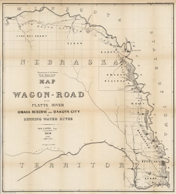
Author
Campbell, Albert
Full Title
Map of the Wagon-Road from Platte River via Omaha Reserve and Dakota City to Running Water River. Geo. L. Sites, Supt. 1858. T.S. Wagner's Lith. Philada. Department of the Interior, Pacific Wagon Roads. (Sen. Ex. Doc. No. 36. Ho. Ex. Doc. No. 108 - 2nd Sess. 35 Cong.)
Publisher
T.S. Wagner's Lith.
Author
Mitchell, Samuel Augustus
Full Title
Mitchell's New National Map Exhibiting The United States With The North American British Provinces, Sandwich Islands, Mexico And Central America, Together with Cuba and other West India Islands. Philadelphia, Published By S. Augustus Mitchell. 1858. Engraved by W. Williams, Map Engraver Philadelphia. Constructed And Engraved By W. Williams, 33 South Fifth St. Philadelphia. Entered ... 1856 by S. Augustus Mitchell ... Pennsylvania. (inset) Map Of The World On The Mercator Projection ... (inset) Map Of The World On The Globular Projection ... (inset) Map Of The Sandwich Islands.
Publisher
S. Augustus Mitchell
Author
[Colton, G.W., Fisher, Richard Swainson]
Full Title
Western Hemisphere. Eastern Hemisphere.
Publisher
J.H. Colton
Author
[Colton, G.W., Fisher, Richard Swainson]
Full Title
The World Illustrating the Principal Features of the Land and the Co-Tidal Lines. The World Showing the Principal Ocean Currents and Boundaries of River Systems.
Publisher
J.H. Colton
Author
[Colton, G.W., Fisher, Richard Swainson]
Full Title
The World Showing the Geographical Distribution & Range of the Principal members of the Animal Kingdom. (inset) Bird Map. The World Illustrating the Productive Industry of Various Countries, & Exhibiting the Principal Features of Commerce and Navigation.
Publisher
J.H. Colton
Author
[Colton, G.W., Fisher, Richard Swainson]
Full Title
North America (physical).
Publisher
J.H. Colton
Author
[Colton, G.W., Fisher, Richard Swainson]
Full Title
North America (political).
Publisher
J.H. Colton
Author
[Colton, G.W., Fisher, Richard Swainson]
Full Title
British Provinces Western Portion (Canada). British Provinces Eastern Portion (Canada). (inset) Vicinity of Niagara River. (inset) Vicinity of Toronto. (inset) Vicinity of Montreal. (inset) Vicinity of Quebec.
Publisher
J.H. Colton
Author
[Colton, G.W., Fisher, Richard Swainson]
Full Title
United States of America (physical). (inset) Hyetal or Rain Chart.
Publisher
J.H. Colton
Author
[Colton, G.W., Fisher, Richard Swainson]
Full Title
United States of America (political).
Publisher
J.H. Colton
Author
[Colton, G.W., Fisher, Richard Swainson]
Full Title
Maine and New Hampshire.
Publisher
J.H. Colton
Author
[Colton, G.W., Fisher, Richard Swainson]
Full Title
Vermont, Massachusetts, Rhode Island, and Connecticut. (inset) Vicinity of Boston.
Publisher
J.H. Colton
Author
[Colton, G.W., Fisher, Richard Swainson]
Full Title
New York, New Jersey, Pennsylvania, and Delaware. (inset) Vicinity of Philadelphia. (inset) Vicinity of New York.
Publisher
J.H. Colton
Author
[Colton, G.W., Fisher, Richard Swainson]
Full Title
Maryland, Virginia, North Carolina, and South Carolina. (inset) The District of Columbia. (inset) Vicinity of Charleston. (inset) Vicinity of Baltimore, Md.
Publisher
J.H. Colton
Author
[Colton, G.W., Fisher, Richard Swainson]
Full Title
Georgia, Alabama, and Florida. (inset) Florida Keys.
Publisher
J.H. Colton
Author
[Colton, G.W., Fisher, Richard Swainson]
Full Title
Mississippi, Louisiana, and Arkansas. (inset) Vicinity of New Orleans.
Publisher
J.H. Colton
Author
[Colton, G.W., Fisher, Richard Swainson]
Full Title
Texas.
Publisher
J.H. Colton
Author
[Colton, G.W., Fisher, Richard Swainson]
Full Title
Ohio, Indiana, Kentucky, and Tennessee. (inset) Vicinity of Cincinnati.
Publisher
J.H. Colton
Author
[Colton, G.W., Fisher, Richard Swainson]
Full Title
Illinois, Iowa, and Missouri. (inset) Vicinity of Chicago. (inset) Vicinity of St. Louis.
Publisher
J.H. Colton
Author
[Colton, G.W., Fisher, Richard Swainson]
Full Title
Michigan and Wisconsin. (inset) Vicinity of Milwaukee. (inset) Vicinity of Detroit.
Publisher
J.H. Colton
Author
[Colton, G.W., Fisher, Richard Swainson]
Full Title
Nebraska and Kansas. Minnesota. (inset) vicinity, of the Falls of St. Anthony.
Publisher
J.H. Colton
Author
[Colton, G.W., Fisher, Richard Swainson]
Full Title
Oregon, Washington, California, Utah, and New Mexico. (inset) Vicinity of San Francisco.
Publisher
J.H. Colton
Author
[Colton, G.W., Fisher, Richard Swainson]
Full Title
California.
Publisher
J.H. Colton
Author
[Colton, G.W., Fisher, Richard Swainson]
Full Title
Mexico and Central America.
Publisher
J.H. Colton
Author
[Colton, G.W., Fisher, Richard Swainson]
Full Title
West Indies. Cuba, Hayti, and Jamaica.
Publisher
J.H. Colton
|