Who What Where WhenREMOVEWHAT
WHERE
|
Author
[Warren, G.K., U. S. Army. Corps of Engineers]
Full Title
Map Of Nebraska And Dakota, And Portions Of The States And Territories Bordering Thereon, Compiled By Bv't Maj. Gen. G.K. Warren, Maj. Engineers. March, 1867 ... Engineer Dep't U.S. Army. Bv't Maj. Gen. A.A. Humphreys, Chief Of Engineers.
Publisher
U.S. Army Engineers
Author
Colton, G.W. & C.B.
Full Title
(Covers to) Colton's Map Of The County Of Westchester. Drawn, Engraved and Published by G.W. & C.B. Colton & Co. 172 William St. New York. 1867. Entered ... 1867 by G.W. & C.B Colton & Co. ... New York.
Publisher
G.W. & C.B Colton & Co.
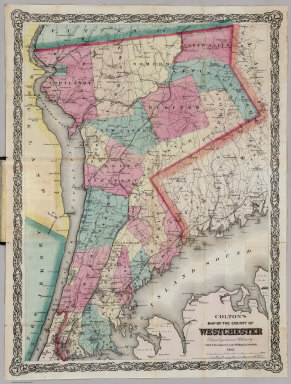
Author
Colton, G.W. & C.B.
Full Title
Colton's Map Of The County Of Westchester. Drawn, Engraved and Published by G.W. & C.B. Colton & Co. 172 William St. New York. 1867. Entered ... 1867 by G.W. & C.B Colton & Co. ... New York.
Publisher
G.W. & C.B Colton & Co.
Author
Fay, T.S.
Full Title
(Covers to) Atlas To Fay's Great Outline Of Geography For High Schools And Families, With A Text-Book. New York: G.P. Putnam's Sons, 4th Avenue and 23d Street.
Publisher
G.P. Putnam & Sons
Author
Fay, T.S.
Full Title
(Title Page) Atlas To Fay's Great Outline Of Geography For High Schools And Families, With A Text-Book. New York: G.P. Putnam's Sons, 4th Avenue and 23d Street.
Publisher
G.P. Putnam & Sons
Author
Fay, T.S.
Full Title
Plate I. (Twelve Perspectives on the Earth in Orbit and Rotation). Drawn by B. Hassenstein, Cartographer. Berlin. Engraved on Stone by Leopold Kraatz. Berlin.
Publisher
G.P. Putnam & Sons
Author
Fay, T.S.
Full Title
Plate II. Natural Land - & Water- Divisions of the World. Drawn by B. Hassenstein, Cartographer. Berlin. Engraved on Stone by Leopold Kraatz. Berlin.
Publisher
G.P. Putnam & Sons
Author
Fay, T.S.
Full Title
Plate III. Principal Countries of the World. Drawn by B. Hassenstein, Cartographer. Berlin. Engraved on Stone by Leopold Kraatz. Berlin.
Publisher
G.P. Putnam & Sons
Author
Fay, T.S.
Full Title
Plate IV. Chief Towns of the World. Voyage Map. (Mercator's Projection). Drawn by B. Hassenstein, Cartographer. Berlin. Engraved on Stone by Leopold Kraatz. Berlin.
Publisher
G.P. Putnam & Sons
Author
Fay, T.S.
Full Title
Plate V A. Outline Map of the German States as they existed in 1865. (inset) Germany and the Holy Roman Empire. Drawn by B. Hassenstein, Cartographer. Berlin. Engraved on Stone by Leopold Kraatz. Berlin.
Publisher
G.P. Putnam & Sons
Author
Fay, T.S.
Full Title
Plate V B. Outline Map of the German States after the War of 1866. (inset) The Former Italy. 1815-1859. Drawn by B. Hassenstein, Cartographer. Berlin. Engraved on Stone by Leopold Kraatz. Berlin.
Publisher
G.P. Putnam & Sons
Author
Fay, T.S.
Full Title
Plate VI A-B. Part of United States of America. On the same scale as Central Europe:Plate VI.B. South-Western Europe. (Germany since 1866). Drawn by B. Hassenstein, Cartographer. Berlin. Engraved on Stone by Leopold Kraatz. Berlin.
Publisher
G.P. Putnam & Sons
Author
Fay, T.S.
Full Title
Plate VII. Outline of Towns, Rivers &co. of the United States. (inset - Fig. 1) State of New York. (inset - Fig. 2) New England States. Drawn by B. Hassenstein, Cartographer. Berlin. Engraved on Stone by Leopold Kraatz. Berlin.
Publisher
G.P. Putnam & Sons
Author
Fay, T.S.
Full Title
Plate VIII. Earth and the Solar System. Drawn by B. Hassenstein, Cartographer. Berlin. Engraved on Stone by Leopold Kraatz. Berlin.
Publisher
G.P. Putnam & Sons
Author
Beers, Frederick W.
Full Title
(Covers to) Atlas Of New York And Vicinity From actual Surveys by and under the direction of F.W. Beers, assisted by Geo. E. Warner & others. Published By F.W. Beers, A.D. Ellis & G.G. Soule. Assistants F.S. Fulmer & Others. 95 Maiden Lane, New York. 1867. Entered ... 1867 by Beers, Ellis & Soule ... New York. Engd. by Worley & Bracher, 320 Chestnut St. Philada. Printed by James McGuigan, Cor. 3d & Dock Sts. Phila.
Publisher
Beers, Ellis & Soule
Author
Beers, Frederick W.
Full Title
(Title Page) Atlas Of New York And Vicinity From actual Surveys by and under the direction of F.W. Beers, assisted by Geo. E. Warner & others. Published By F.W. Beers, A.D. Ellis & G.G. Soule. Assistants F.S. Fulmer & Others. 95 Maiden Lane, New York. 1867. Entered ... 1867 by Beers, Ellis & Soule ... New York. Engd. by Worley & Bracher, 320 Chestnut St. Philada. Printed by James McGuigan, Cor. 3d & Dock Sts. Phila.
Publisher
Beers, Ellis & Soule
Author
Beers, Frederick W.
Full Title
Table of Contents.
Publisher
Beers, Ellis & Soule
Author
Beers, Frederick W.
Full Title
(Text Page) Table of Air-Line Distances.
Publisher
Beers, Ellis & Soule
Author
Beers, Frederick W.
Full Title
Map of New York and Vicinity Accompanying Atlas of New York and Vicinity, Published by Beers, Ellis & Soule, 95 Maiden Lane, New York.
Publisher
Beers, Ellis & Soule
Author
Beers, Frederick W.
Full Title
Plan of New York and Brooklyn.
Publisher
Beers, Ellis & Soule
Author
Beers, Frederick W.
Full Title
Plans of Westchester, West Farms, Morrisania, Westchester Co. and Part of New York County.
Publisher
Beers, Ellis & Soule
Author
Beers, Frederick W.
Full Title
Town of Yonkers, Westchester Co., N.Y.
Publisher
Beers, Ellis & Soule
Author
Beers, Frederick W.
Full Title
Plan (Town) of East Chester, Pelham and New Rochelle, Westchester Co., N.Y.
Publisher
Beers, Ellis & Soule
Author
Beers, Frederick W.
Full Title
Town of Greenburgh, Westchester Co., N.Y.
Publisher
Beers, Ellis & Soule
Author
Beers, Frederick W.
Full Title
Mamaroneck, Scarsdale, White Plains, Harrison & Rye, Westchester Co., N.Y.
Publisher
Beers, Ellis & Soule
Author
Beers, Frederick W.
Full Title
Port Chester, Westchester Co., N.Y.
Publisher
Beers, Ellis & Soule
Author
Beers, Frederick W.
Full Title
Town of Ossining, Town of Mt. Pleasant, Westchester Co., N.Y. (inset) Pleasantville Station.
Publisher
Beers, Ellis & Soule
Author
Beers, Frederick W.
Full Title
Town of North Castle, Westchester Co., N.Y. (insets) Armonk. Kensico.
Publisher
Beers, Ellis & Soule
Author
Beers, Frederick W.
Full Title
Town of Newcastle, Westchester Co., N.Y. (insets) Newcastle. Chappaqua.
Publisher
Beers, Ellis & Soule
Author
Beers, Frederick W.
Full Title
Town of Bedford, Westchester Co., N.Y.
Publisher
Beers, Ellis & Soule
Author
Beers, Frederick W.
Full Title
Town of Poundridge, Westchester Co., N.Y.
Publisher
Beers, Ellis & Soule
Author
Beers, Frederick W.
Full Title
Town of Lewisboro, Westchester Co., N.Y. (insets) Goldens Bridge. Cross River. South Salem.
Publisher
Beers, Ellis & Soule
Author
Beers, Frederick W.
Full Title
Town of Cortlandt, Westchester Co., N.Y.
Publisher
Beers, Ellis & Soule
Author
Beers, Frederick W.
Full Title
Town of Yorktown, Westchester Co., N.Y. (insets) Jefferson Valley. Shrub Oak.
Publisher
Beers, Ellis & Soule
Author
Beers, Frederick W.
Full Title
Town of Somers, Westchester Co., N.Y. (inset) Somers.
Publisher
Beers, Ellis & Soule
Author
Beers, Frederick W.
Full Title
Town of North Salem, Westchester Co., N.Y. (insets) Croton Falls. North Salem. Purdy Station.
Publisher
Beers, Ellis & Soule
Author
Beers, Frederick W.
Full Title
Town of Greenwich, Fairfield Co., Conn.
Publisher
Beers, Ellis & Soule
Author
Beers, Frederick W.
Full Title
Greenwich, Fairfield Co., Conn. (insets) Coscob. Rocky Net Point. Mianus. Glenville. Banksville.
Publisher
Beers, Ellis & Soule
Author
Beers, Frederick W.
Full Title
Town of Stamford, Fairfield Co., Conn. (insets) Long Ridge. High Ridge. North Stamford.
Publisher
Beers, Ellis & Soule
Author
Beers, Frederick W.
Full Title
Plan of Southern Part of the Town of Stamford, Fairfield Co., Conn.
Publisher
Beers, Ellis & Soule
Author
Beers, Frederick W.
Full Title
Plan of Stamford, Fairfield Co., Conn.
Publisher
Beers, Ellis & Soule
Author
Beers, Frederick W.
Full Title
Town of Darien, Fairfield Co., Conn. (inset) Darien. Darien Depot.
Publisher
Beers, Ellis & Soule
Author
Beers, Frederick W.
Full Title
Town of Norwalk, Fairfield Co., Conn. (inset) Winnipauk.
Publisher
Beers, Ellis & Soule
Author
Beers, Frederick W.
Full Title
Plan of Norwalk, Plan of South Norwalk. Fairfield County, Connecticut.
Publisher
Beers, Ellis & Soule
Author
Beers, Frederick W.
Full Title
Town of Westport, Fairfield Co., Conn. (inset) Saugatuck.
Publisher
Beers, Ellis & Soule
Author
Beers, Frederick W.
Full Title
Westport ... Fairfield Co., Conn.
Publisher
Beers, Ellis & Soule
Author
Beers, Frederick W.
Full Title
Town of Fairfield, Fairfield Co., Conn.
Publisher
Beers, Ellis & Soule
Author
Beers, Frederick W.
Full Title
Greenfield Hill. Southport. Black Rock. Fairfield.
Publisher
Beers, Ellis & Soule
Author
Beers, Frederick W.
Full Title
Town of Bridgeport, Fairfield Co., Conn.
Publisher
Beers, Ellis & Soule
|