Who What Where WhenREMOVEWHATShow More |
Author
Campbell, R.A.
Full Title
Campbell's topographical & sectional map of Rock Island, Henry and Mercer counties. (Drawn by R.A. Campbell and H.F. Walling). Entered ... 1869 by R.A. Campbell ... Pennsylvania. (1870)
Publisher
[R.A. Campbell, S.A. Mitchell, Jr.]
Author
Campbell, R.A.
Full Title
Campbell's topographical & sectional map of Bureau, Putnam, Stark, Marshall counties. (Drawn by R.A. Campbell and H.F. Walling). Entered ... 1869 by R.A. Campbell ... Pennsylvania. (1870)
Publisher
[R.A. Campbell, S.A. Mitchell, Jr.]
Author
Campbell, R.A.
Full Title
Campbell's topographical & sectional map of La Salle, Grundy and Livingston counties. (Drawn by R.A. Campbell and H.F. Walling). Entered ... 1869 by R.A. Campbell ... Pennsylvania. (1870)
Publisher
[R.A. Campbell, S.A. Mitchell, Jr.]
Author
Campbell, R.A.
Full Title
Campbell's topographical & sectional map of Kankakee, Iroquois, and Ford counties. (Drawn by R.A. Campbell and H.F. Walling). Entered ... 1869 by R.A. Campbell ... Pennsylvania. (1870)
Publisher
[R.A. Campbell, S.A. Mitchell, Jr.]
Author
Campbell, R.A.
Full Title
Campbell's topographical & sectional map of Peoria, Woodford and Tazewell counties. (Drawn by R.A. Campbell and H.F. Walling). Entered ... 1869 by R.A. Campbell ... Pennsylvania. (1870)
Publisher
[R.A. Campbell, S.A. Mitchell, Jr.]
Author
Campbell, R.A.
Full Title
Campbell's topographical & sectional map of Henderson, Warren, and Knox counties. (Drawn by R.A. Campbell and H.F. Walling). Entered ... 1869 by R.A. Campbell ... Pennsylvania. (1870)
Publisher
[R.A. Campbell, S.A. Mitchell, Jr.]
Author
Campbell, R.A.
Full Title
Campbell's topographical & sectional map of Hancock, McDonough, Schuyler counties. (Drawn by R.A. Campbell and H.F. Walling). Entered ... 1869 by R.A. Campbell ... Pennsylvania. (1870)
Publisher
[R.A. Campbell, S.A. Mitchell, Jr.]
Author
Campbell, R.A.
Full Title
Fulton, Mason, Cass, & Menard counties. (Drawn by R.A. Campbell and H.F. Walling). Entered ... 1869 by R.A. Campbell ... Pennsylvania. (1870)
Publisher
[R.A. Campbell, S.A. Mitchell, Jr.]
Author
Campbell, R.A.
Full Title
Campbell's topographical & sectional map of McLean, De Witt and Piatt counties. (Drawn by R.A. Campbell and H.F. Walling). Entered ... 1869 by R.A. Campbell ... Pennsylvania. (1870)
Publisher
[R.A. Campbell, S.A. Mitchell, Jr.]
Author
Campbell, R.A.
Full Title
Campbell's topographical & sectional map of Champaign, and Vermillion (sic) counties. (Drawn by R.A. Campbell and H.F. Walling). Entered ... 1869 by R.A. Campbell ... Pennsylvania. (1870)
Publisher
[R.A. Campbell, S.A. Mitchell, Jr.]
Author
Campbell, R.A.
Full Title
Campbell's topographical & sectional map of Logan, Sangamon and Christian counties. (Drawn by R.A. Campbell and H.F. Walling). Entered ... 1869 by R.A. Campbell ... Pennsylvania. (1870)
Publisher
[R.A. Campbell, S.A. Mitchell, Jr.]
Author
Campbell, R.A.
Full Title
Campbell's topographical & sectional map of Adams, Brown, Pike counties. (Drawn by R.A. Campbell and H.F. Walling). Entered ... 1869 by R.A. Campbell ... Pennsylvania. (1870)
Publisher
[R.A. Campbell, S.A. Mitchell, Jr.]
Author
Campbell, R.A.
Full Title
Campbell's topographical & sectional map of Morgan, Scott, Greene, Calhoun, Jersey counties. (Drawn by R.A. Campbell and H.F. Walling). Entered ... 1869 by R.A. Campbell ... Pennsylvania. (1870)
Publisher
[R.A. Campbell, S.A. Mitchell, Jr.]
Author
Campbell, R.A.
Full Title
Campbell's topographical & sectional map of Macoupin, Montgomery counties. (Drawn by R.A. Campbell and H.F. Walling). Entered ... 1869 by R.A. Campbell ... Pennsylvania. (1870)
Publisher
[R.A. Campbell, S.A. Mitchell, Jr.]
Author
Campbell, R.A.
Full Title
Campbell's topographical & sectional map of Macon, Moultry (i.e. Moultrie), and Shelby, counties. (Drawn by R.A. Campbell and H.F. Walling). Entered ... 1869 by R.A. Campbell ... Pennsylvania. (1870)
Publisher
[R.A. Campbell, S.A. Mitchell, Jr.]
Author
Campbell, R.A.
Full Title
Campbell's topographical & sectional map of Douglas, Edgar, Coles, Cumberland, Clark counties. (Drawn by R.A. Campbell and H.F. Walling). Entered ... 1869 by R.A. Campbell ... Pennsylvania. (1870)
Publisher
[R.A. Campbell, S.A. Mitchell, Jr.]
Author
Campbell, R.A.
Full Title
Campbell's topographical & sectional map of Jasper, Crawford, Clay, Lawrence, Richland, counties. (Drawn by R.A. Campbell and H.F. Walling). Entered ... 1869 by R.A. Campbell ... Pennsylvania. (1870)
Publisher
[R.A. Campbell, S.A. Mitchell, Jr.]
Author
Campbell, R.A.
Full Title
Campbell's topographical & sectional map of Fayette, Effingham and Marion, counties. (Drawn by R.A. Campbell and H.F. Walling). Entered ... 1869 by R.A. Campbell ... Pennsylvania. (1870)
Publisher
[R.A. Campbell, S.A. Mitchell, Jr.]
Author
Campbell, R.A.
Full Title
Campbell's topographical & sectional map of Bond, Clinton, Washington, counties. (Drawn by R.A. Campbell and H.F. Walling). Entered ... 1869 by R.A. Campbell ... Pennsylvania. (1870)
Publisher
[R.A. Campbell, S.A. Mitchell, Jr.]
Author
Campbell, R.A.
Full Title
Campbell's topographical & sectional map of Madison, St. Clair, and Monroe counties. (Drawn by R.A. Campbell and H.F. Walling). Entered ... 1869 by R.A. Campbell ... Pennsylvania. (1870)
Publisher
[R.A. Campbell, S.A. Mitchell, Jr.]
Author
Campbell, R.A.
Full Title
Campbell's topographical & sectional map of Randolph, Perry, and Jackson counties. (Drawn by R.A. Campbell and H.F. Walling). Entered ... 1869 by R.A. Campbell ... Pennsylvania. (1870)
Publisher
[R.A. Campbell, S.A. Mitchell, Jr.]
Author
Campbell, R.A.
Full Title
Campbell's topographical & sectional map of Jefferson, Franklin and Williamson counties. (Drawn by R.A. Campbell and H.F. Walling). Entered ... 1869 by R.A. Campbell ... Pennsylvania. (1870)
Publisher
[R.A. Campbell, S.A. Mitchell, Jr.]
Author
Campbell, R.A.
Full Title
Campbell's topographical & sectional map of Wayne, Edwards, Wabash, Hamilton, and White counties. (Drawn by R.A. Campbell and H.F. Walling). Entered ... 1869 by R.A. Campbell ... Pennsylvania. (1870)
Publisher
[R.A. Campbell, S.A. Mitchell, Jr.]
Author
Campbell, R.A.
Full Title
Campbell's topographical & sectional map of Saline, Gallatin, Hardin, and Pope, counties. (Drawn by R.A. Campbell and H.F. Walling). Entered ... 1869 by R.A. Campbell ... Pennsylvania. (1870)
Publisher
[R.A. Campbell, S.A. Mitchell, Jr.]
Author
Campbell, R.A.
Full Title
Campbell's topographical & sectional map of Union, Johnson, Alexander, Pulaski, and Massac counties. (Drawn by R.A. Campbell and H.F. Walling). Entered ... 1869 by R.A. Campbell ... Pennsylvania. (1870)
Publisher
[R.A. Campbell, S.A. Mitchell, Jr.]
Author
Campbell, R.A.
Full Title
Climatological map of the state of Illinois showing the isothermal lines. Comparative amount of rainfall &c. Prepared expressly for Campbell's Illinois atlas. (Drawn by R.A. Campbell and H.F. Walling). Entered ... 1869 by R.A. Campbell ... Pennsylvania. (1870)
Publisher
[R.A. Campbell, S.A. Mitchell, Jr.]
Author
[Campbell, R.A., Worthen, Amos Henry, 1813-1888]
Full Title
Worthens new geological map of Illinois. Prepared expressly for Campbell's Illinois atlas. (Drawn by R.A. Campbell and H.F. Walling). Entered ... 1869 by R.A. Campbell ... Pennsylvania. (1870)
Publisher
[R.A. Campbell, S.A. Mitchell, Jr.]
Author
[Great Britain. Ordnance Survey, Mudge, William (1762-1820), Colby, Thomas, Baker, Benjamin, Great Britain. Board of Ordnance]
Full Title
(Covers to) Ordnance Survey of Great Britain. Old Series or First Edition, One-Inch Map of England and Wales.
Publisher
[W. Mudge; Ordnance Survey, Thomas Colby (1784-1852)]
Author
[Great Britain. Ordnance Survey, Mudge, William (1762-1820), Colby, Thomas, Baker, Benjamin, Great Britain. Board of Ordnance]
Full Title
(Text Page) (Example of Map Cover showing the Archduke's Mark and a Map Number).
Publisher
[W. Mudge; Ordnance Survey, Thomas Colby (1784-1852)]
Author
[Great Britain. Ordnance Survey, Mudge, William (1762-1820), Colby, Thomas, Baker, Benjamin, Great Britain. Board of Ordnance]
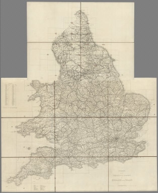
Full Title
(Index Map) Index to the Ordnance Survey of England and Wales.
Publisher
[W. Mudge; Ordnance Survey, Thomas Colby (1784-1852)]
Author
[Great Britain. Ordnance Survey, Mudge, William (1762-1820), Colby, Thomas, Baker, Benjamin, Great Britain. Board of Ordnance]
Full Title
(Index Map) Index to the Ordnance Survey of England and Wales, Published in Sheets on a Scale of one inch to a Mile.
Publisher
[W. Mudge; Ordnance Survey, Thomas Colby (1784-1852)]
Author
[Great Britain. Ordnance Survey, Mudge, William (1762-1820), Colby, Thomas, Baker, Benjamin, Great Britain. Board of Ordnance]
Full Title
(Legend) Examples for the Size and Characters (fonts) of the Names in the Ordnance Map.
Publisher
[W. Mudge; Ordnance Survey, Thomas Colby (1784-1852)]
Author
[Great Britain. Ordnance Survey, Mudge, William (1762-1820), Colby, Thomas, Baker, Benjamin, Great Britain. Board of Ordnance]
Full Title
108. Wooler.
Publisher
[W. Mudge; Ordnance Survey, Thomas Colby (1784-1852)]
Author
Schubert, Friedrich Theodor
Full Title
(Covers to) Kriegsstrassen Karte eines Theiles von Russland und der angraenzenden laender; nach der unter der Leitung des Russ. kaiserlichen Generalstabes vom General Major Schubert im Masstabe von 1:1680000 im Jahre 1829 herausgegebenen Karte auf das Mass von 1:1400000 vergrossert, von dem k.k. osterr. Generalquartiermeisterstabe herausgegeben im Jahre 1837. "Berichtigungen im Jahr 1854 u. 1856 ... )
Publisher
Generalquartiermeisterstab
Author
Schubert, Friedrich Theodor
Full Title
(Index Map to) Squelette der Kriegsstrassenkarte von Russland. Titel und Zeichenerklärung. (to accompany) Kriegsstrassen Karte eines Theiles von Russland und der angraenzenden laender; nach der unter der Leitung des Russ. kaiserlichen Generalstabes vom General Major Schubert im Masstabe von 1:1680000 im Jahre 1829 herausgegebenen Karte auf das Mass von 1:1400000 vergrossert, von dem k.k. osterr. Generalquartiermeisterstabe herausgegeben im Jahre 1837. "Berichtigungen im Jahr 1854 u. 1856 ... )
Publisher
Generalquartiermeisterstab
Author
Schubert, Friedrich Theodor
Full Title
(Covers to) I. Uleaborg. Politische eintheilung. (to accompany) Kriegsstrassen Karte eines Theiles von Russland und der angraenzenden laender.
Publisher
Generalquartiermeisterstab
Author
Schubert, Friedrich Theodor
Full Title
(Uleaborg. Politische eintheilung). (to accompany) Kriegsstrassen Karte eines Theiles von Russland und der angraenzenden laender. (on upper left margin) I.
Publisher
Generalquartiermeisterstab
Author
Schubert, Friedrich Theodor
Full Title
(Covers to) II. Archangelsk. (to accompany) Kriegsstrassen Karte eines Theiles von Russland und der angraenzenden laender.
Publisher
Generalquartiermeisterstab
Author
Schubert, Friedrich Theodor
Full Title
(Archangelsk). (to accompany) Kriegsstrassen Karte eines Theiles von Russland und der angraenzenden laender. (on upper left margin) II.
Publisher
Generalquartiermeisterstab
Author
Schubert, Friedrich Theodor
Full Title
(Covers to) III. Mezen. Titel, - Maastabe, Zeichen-Erklarung. (to accompany) Kriegsstrassen Karte eines Theiles von Russland und der angraenzenden laender.
Publisher
Generalquartiermeisterstab
Author
Schubert, Friedrich Theodor
Full Title
(Title Page to) Kriegsstrassen Karte eines Theiles von Russland und der angraenzenden laender; nach der unter der Leitung des Russ. kaiserlichen Generalstabes vom General Major Schubert im Masstabe von 1:1680000 im Jahre 1829 herausgegebenen Karte auf das Mass von 1:1400000 vergrossert, von dem k.k. osterr. Generalquartiermeisterstabe herausgegeben im Jahre 1837. "Berichtigungen im Jahr 1854 u. 1856 ... ). (on upper left margin) III.
Publisher
Generalquartiermeisterstab
Author
Schubert, Friedrich Theodor
Full Title
(Covers to) IV. Stockhom. (to Accompany) Kriegsstrassen Karte eines Theiles von Russland und der angraenzenden laender.
Publisher
Generalquartiermeisterstab
Author
Schubert, Friedrich Theodor
Full Title
(Stockhom). (to Accompany) Kriegsstrassen Karte eines Theiles von Russland und der angraenzenden laender. (on upper left margin) IV.
Publisher
Generalquartiermeisterstab
Author
Schubert, Friedrich Theodor
Full Title
(Covers to) V. Petersburg. (to Accompany) Kriegsstrassen Karte eines Theiles von Russland und der angraenzenden laender.
Publisher
Generalquartiermeisterstab
Author
Schubert, Friedrich Theodor
Full Title
(St. Petersburg). (to Accompany) Kriegsstrassen Karte eines Theiles von Russland und der angraenzenden laender. (on upper left margin) V.
Publisher
Generalquartiermeisterstab
Author
Schubert, Friedrich Theodor
Full Title
(Covers to) VI. Kostroma. (to Accompany) Kriegsstrassen Karte eines Theiles von Russland und der angraenzenden laender.
Publisher
Generalquartiermeisterstab
Author
Schubert, Friedrich Theodor
Full Title
(Kostroma). (to Accompany) Kriegsstrassen Karte eines Theiles von Russland und der angraenzenden laender. (on upper left margin) VI.
Publisher
Generalquartiermeisterstab
Author
Schubert, Friedrich Theodor
Full Title
(Covers to) VII. Konigsberg. (to Accompany) Kriegsstrassen Karte eines Theiles von Russland und der angraenzenden laender.
Publisher
Generalquartiermeisterstab
Author
Schubert, Friedrich Theodor
Full Title
(Konigsberg). (to Accompany) Kriegsstrassen Karte eines Theiles von Russland und der angraenzenden laender. (on upper left margin) VII.
Publisher
Generalquartiermeisterstab
|