Who What Where WhenREMOVEWHATShow MoreWHERE
|
Author
Gray, Ormando Willis
Full Title
Gray's Atlas Map of Missouri.
Publisher
Stedman, Brown & Lyon
Author
Gray, Ormando Willis
Full Title
Gray's Atlas Map of Chicago.
Publisher
Stedman, Brown & Lyon
Author
Gray, Ormando Willis
Full Title
Gray's Atlas Map of Iowa.
Publisher
Stedman, Brown & Lyon
Author
Gray, Ormando Willis
Full Title
Gray's Atlas Map of Lake Superior and the Northern Part of Michigan. No. 1.
Publisher
Stedman, Brown & Lyon
Author
Gray, Ormando Willis
Full Title
Gray's Atlas Map of Michigan. No. 2.
Publisher
Stedman, Brown & Lyon
Author
Gray, Ormando Willis
Full Title
Gray's Atlas Map of Minnesota. (inset continuation of main map).
Publisher
Stedman, Brown & Lyon
Author
Gray, Ormando Willis
Full Title
Gray's Atlas Map of Wisconsin. (inset) Vicinity of Milwaukee. Dakota.
Publisher
Stedman, Brown & Lyon
Author
Gray, Ormando Willis
Full Title
Gray's Atlas Map of Kansas.
Publisher
Stedman, Brown & Lyon
Author
Gray, Ormando Willis
Full Title
Gray's Atlas Map of Indian Territory (Oklahoma). Gray's Atlas Nebraska. Drawn by Frank A. Gray. Entered ...1874 by O.W. Gray ....
Publisher
Stedman, Brown & Lyon
Author
Gray, Ormando Willis
Full Title
Colorado. Idaho, Montana, and Wyoming. Drawn by Frank A. Gray.
Publisher
Stedman, Brown & Lyon
Author
Gray, Ormando Willis
Full Title
Oregon and Washington. Drawn by F.A. Gray.
Publisher
Stedman, Brown & Lyon
Author
Gray, Ormando Willis
Full Title
Gray's Atlas Map of New Mexico and Arizona.
Publisher
Stedman, Brown & Lyon
Author
Gray, Ormando Willis
Full Title
Gray's Atlas California and Nevada. (inset) The Vicinity of San Francisco. (inset) Map of the Yosemite Valley, Mariposa Co., Cal. from the California Geological Survey.
Publisher
Stedman, Brown & Lyon
Author
Gray, Ormando Willis
Full Title
Map of the City of Sacramento, the Capital of California. By J.R. Ray, City Surveyor, 1873.
Publisher
Stedman, Brown & Lyon
Author
Gray, Ormando Willis
Full Title
San Francisco.
Publisher
Stedman, Brown & Lyon
Author
Gray, Ormando Willis
Full Title
Gray's Atlas New Railroad and County Map of the States of Oregon, California, and Nevada Compiled and Drawn by Frank A. Gray. Published by O.W. Gray, Philadelphia. (inset) Enlarged Plan of the Vicinity of San Francisco and Sacramento.
Publisher
Stedman, Brown & Lyon
Author
Watson, Gaylord
Full Title
(Covers to) Watson's New Map Of New-York And Adjacent Cities. Published By Gaylord Watson, 16 Beekman St. 1874. Entered ... 1869, by Gaylord Watson ... New York. (inset) Map showing the Hudson River And Adjoining Country.
Publisher
Gaylord Watson
Author
Watson, Gaylord
Full Title
(Covers to) Watson's New County and Railroad Map of the Western States and Territories, With the Cities of New York, Chicago, St. Louis and San Francisco, 1874. Published by Gaylord Watson, 16 Beekman St., New York. Entered ... 1871, by Gaylord Watson ... Washington. (with) 5 inset maps: City of San Francisco; City of New York to 110th Street; City of Chicago; City of St. Louis; War Department Weather Map.
Publisher
Gaylord Watson
Author
Watson, Gaylord
Full Title
(Covers to) Watson's New County and Railroad Map of the United States and the Dominion of Canada Compiled From the Latest Official Sources, 1874. Published by Gaylord Watson, 16 Beekman St., New York. Entered ... 1871, by Gaylord Watson ... Washington. (with) 5 inset maps: Routes of the Union, Central & Kansas Pacific Railroad; Vicinity of Boston; Vicinity of Philadelphia; Vicinity of New York; Lower Part of Florida.
Publisher
Gaylord Watson
Author
Watson, Gaylord
Full Title
Watson's New Map Of New-York And Adjacent Cities. Published By Gaylord Watson, 16 Beekman St. 1874. Entered ... 1869, by Gaylord Watson ... New York. (inset) Map showing the Hudson River And Adjoining Country.
Publisher
Gaylord Watson
Author
Watson, Gaylord
Full Title
Watson's New County and Railroad Map of the Western States and Territories, With the Cities of New York, Chicago, St. Louis and San Francisco, 1874. Published by Gaylord Watson, 16 Beekman St., New York. Entered ... 1871, by Gaylord Watson ... Washington. (with) 5 inset maps: City of San Francisco; City of New York to 110th Street; City of Chicago; City of St. Louis; War Department Weather Map.
Publisher
Gaylord Watson
Author
Watson, Gaylord
Full Title
Watson's New County and Railroad Map of the United States and the Dominion of Canada Compiled From the Latest Official Sources, 1874. Published by Gaylord Watson, 16 Beekman St., New York. Entered ... 1871, by Gaylord Watson ... Washington. (with) 5 inset maps: Routes of the Union, Central & Kansas Pacific Railroad; Vicinity of Boston; Vicinity of Philadelphia; Vicinity of New York; Lower Part of Florida.
Publisher
Gaylord Watson
Author
Viele, Egbert L.
Full Title
(Covers to) Topographical Atlas Of The City Of New York Including The Annexed Territory. Showing original water courses and made land. Prepared Under The Direction Of Egbert L. Viele, Civil and Topographical Engineer. 234 Broadway, N.Y. 1874. Eugene Quackenbush, C.E. Entered ... 1874, by Egbert L. Viele in the Office of the Librarian of Congress. Julius Bien, Photo Lith.
Publisher
E.L. Viele
Author
Viele, Egbert L.
Full Title
Topographical Atlas Of The City Of New York Including The Annexed Territory. I. (Southernmost portion). Showing original water courses and made land. Prepared Under The Direction Of Egbert L. Viele, Civil and Topographical Engineer. 234 Broadway, N.Y. 1874. Eugene Quackenbush, C.E. Entered ... 1874, by Egbert L. Viele in the Office of the Librarian of Congress. Julius Bien, Photo Lith.
Publisher
E.L. Viele
Author
Viele, Egbert L.
Full Title
Topographical Atlas Of The City Of New York Including The Annexed Territory. II. (Next to southernmost portion). Showing original water courses and made land. Prepared Under The Direction Of Egbert L. Viele, Civil and Topographical Engineer. 234 Broadway, N.Y. 1874. Eugene Quackenbush, C.E. Entered ... 1874, by Egbert L. Viele in the Office of the Librarian of Congress. Julius Bien, Photo Lith.
Publisher
E.L. Viele
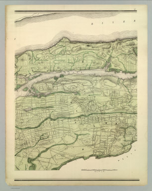
Author
Viele, Egbert L.
Full Title
Topographical Atlas Of The City Of New York Including The Annexed Territory. III. (Central portion). Showing original water courses and made land. Prepared Under The Direction Of Egbert L. Viele, Civil and Topographical Engineer. 234 Broadway, N.Y. 1874. Eugene Quackenbush, C.E. Entered ... 1874, by Egbert L. Viele in the Office of the Librarian of Congress. Julius Bien, Photo Lith.
Publisher
E.L. Viele
Author
Viele, Egbert L.
Full Title
Topographical Atlas Of The City Of New York Including The Annexed Territory. IV. (Next to northernmost portion). Showing original water courses and made land. Prepared Under The Direction Of Egbert L. Viele, Civil and Topographical Engineer. 234 Broadway, N.Y. 1874. Eugene Quackenbush, C.E. Entered ... 1874, by Egbert L. Viele in the Office of the Librarian of Congress. Julius Bien, Photo Lith.
Publisher
E.L. Viele
Author
Viele, Egbert L.
Full Title
Topographical Atlas Of The City Of New York Including The Annexed Territory. V. (Northernmost portion). Showing original water courses and made land. Prepared Under The Direction Of Egbert L. Viele, Civil and Topographical Engineer. 234 Broadway, N.Y. 1874. Eugene Quackenbush, C.E. Entered ... 1874, by Egbert L. Viele in the Office of the Librarian of Congress. Julius Bien, Photo Lith.
Publisher
E.L. Viele
Author
Viele, Egbert L.
Full Title
(Composite of) Topographical Atlas Of The City Of New York Including The Annexed Territory. Showing original water courses and made land. Prepared Under The Direction Of Egbert L. Viele, Civil and Topographical Engineer. 234 Broadway, N.Y. 1874. Eugene Quackenbush, C.E. Entered ... 1874, by Egbert L. Viele in the Office of the Librarian of Congress. Julius Bien, Photo Lith.
Publisher
E.L. Viele
Author
U.S. War Department, Chief of Engineers
Full Title
Map III illustrating the Military Operations of the Atlanta Campaign. This map includes the region extending from Rome, Kingston and Cassville on the north to include Dallas and Marietta on the south and exhibits the Works of the United States and Confederate Forces. 1864. Maj. Genl. W.T. Sherman, commanding U.S. Forces. Genl. J.E. Johnston, commanding Conf. Forces. Compiled by Authority of the Hon. The Secretary Of War ... 1876. Authorities. Surveys made by J.T. Dodge and H.H. Ruger; Civil Eng'rs. and Captured Confederate maps. Am. Photo-Lithographic Co. N.Y. (Osborne's Process.)
Publisher
American Photo-Lithographic Co.
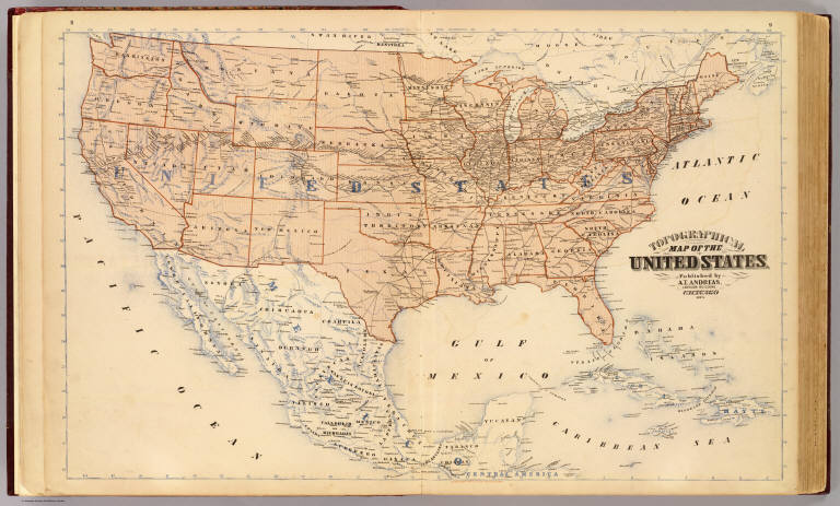
Author
Andreas, A. T. (Alfred Theodore), 1839-1900
Full Title
Topographical map of the United States. Published by A.T. Andreas, Lakeside Building, Chicago, 1873. (Chas. Shober & Co. Proprietors of Chicago Lith. Co.)
Publisher
A.T. Andreas
Author
[Vorzet, Ed.Dumas, Le Comte de Paris]
Full Title
(Covers and Title Page to) Histoire de la Guerre Civile en Amerique par M. Le Comte de Paris, Ancien Aide de Camp du General Mac Clellan (McClellan). ... Paris. Michel Levy Freres, Editeurs, Rue Auber, 3, Place de L'Opera. Librairie Novelle, Boulevard des Italiens, 15 au Coin de la Rue de Grammont, M DCCC LXXIV, Tous droits reserves. Premiere et Deuxieme Livraisons Contenant Les Planchers I a IX.
Publisher
Michel Levy Freres
Author
[Vorzet, Ed.Dumas, Le Comte de Paris]
Full Title
Planche I. Carte Generale du Theatre de la Guerre. (inset) Cote de la Georgie. Dessine par Ed. Dumas Vorzet. Michel Levy, freres. Editeurs. Imp. Becquet, Paris. Grave par L. Wuhrer, R. Gay-Lussac 52.
Publisher
Michel Levy Freres
Author
[Vorzet, Ed.Dumas, Le Comte de Paris]
Full Title
Planche II. Virginie et Maryland. (inset) Environs de Leesburg. Carnifex Ferry. Dessine par Ed. Dumas Vorzet. Michel Levy, freres. Editeurs. Imp. Becquet, Paris. Grave par L. Wuhrer, R. Gay-Lussac 52.
Publisher
Michel Levy Freres
Author
[Vorzet, Ed.Dumas, Le Comte de Paris]
Full Title
Planche III. Kentucky et Tennessee. Dessine par Ed. Dumas Vorzet. Michel Levy, freres. Editeurs. Imp. Becquet, Paris. Grave par L. Wuhrer, R. Gay-Lussac 52.
Publisher
Michel Levy Freres
Author
[Vorzet, Ed.Dumas, Le Comte de Paris]
Full Title
Planche IV. Missouri et Arkansas. (insets) Environs de Lexington. Champ de Bataille de Wilson's Creek. Dessine par Ed. Dumas Vorzet. Michel Levy, freres. Editeurs. Imp. Becquet, Paris. Grave par L. Wuhrer, R. Gay-Lussac 52.
Publisher
Michel Levy Freres
Author
[Vorzet, Ed.Dumas, Le Comte de Paris]
Full Title
Planche V. Environs de Washington et du Bull Run. Dessine par Ed. Dumas Vorzet. Michel Levy, freres. Editeurs. Imp. Becquet, Paris. Grave par L. Wuhrer, R. Gay-Lussac 52.
Publisher
Michel Levy Freres
Author
[Vorzet, Ed.Dumas, Le Comte de Paris]
Full Title
Planche VI. Pamlico Sound. (Carolina du Nord). Dessine par Ed. Dumas Vorzet. Michel Levy, freres. Editeurs. Imp. Becquet, Paris. Grave par L. Wuhrer, R. Gay-Lussac 52.
Publisher
Michel Levy Freres
Author
[Vorzet, Ed.Dumas, Le Comte de Paris]
Full Title
Plache VII. Sea Islands. (Carolina du Sud). Dessine par Ed. Dumas Vorzet. Michel Levy, freres. Editeurs. Imp. Becquet, Paris. Grave par L. Wuhrer, R. Gay-Lussac 52.
Publisher
Michel Levy Freres
Author
[Vorzet, Ed.Dumas, Le Comte de Paris]
Full Title
Planche VIII. Belmont. Pea Ridge. Hampton Road. Ise. No. 10. Dessine par Ed. Dumas Vorzet. Michel Levy, freres. Editeurs. Imp. Becquet, Paris. Grave par L. Wuhrer, R. Gay-Lussac 52.
Publisher
Michel Levy Freres
Author
[Vorzet, Ed.Dumas, Le Comte de Paris]
Full Title
Planche IX. Fort Henry. Fort Donelson. Shiloh. Dessine par Ed. Dumas Vorzet. Michel Levy, freres. Editeurs. Imp. Becquet, Paris. Grave par L. Wuhrer, R. Gay-Lussac 52.
Publisher
Michel Levy Freres
Author
[California Geological Survey, Whitney, J.D.]
Full Title
Map of the Routes from San Francisco to the Yosemite Valley. Prepared to accompany the pocket edition of the Yosemite Guide Book. (State Geol. Survey). 1872.
Publisher
University Press
Author
[Ludlow, William, 1843-1901, United States. Army. Corps of Engineer]
Full Title
A geological map of the Black Hills: by Professor N.H. Winchell to accompany the report of Capt. William Ludlow U.S. Engineers. (to accompany) Report of a reconnaissance of the Black Hills of Dakota, made in the summer of 1874. By William Ludlow, Captain of Engineers, Bvt. Lieut. Colonel, U. S. Army; Chief Engineer Department of Dakota. Washington : Government Printing Office. 1875.
Publisher
Government Printing Office
Author
[Ludlow, William, 1843-1901, United States. Army. Corps of Engineer]
Full Title
Map of a reconnaissance of the Black Hills of Dakota, July and August 1874. With troops under command of Lt. Col. G.A.Custer, 7th., Cavalry, by Capt. Wm. Ludlow, Corps of Engineers. (on upper margin) Brig. Genl. A.A.Humphreys, Chief of Engineers U.S.A. ; Brig. Genl. A.H. Terry Comdg. Department. (to accompany) Report of a reconnaissance of the Black Hills of Dakota, made in the summer of 1874. By William Ludlow, Captain of Engineers, Bvt. Lieut. Colonel, U. S. Army; Chief Engineer Department of Dakota. Washington : Government Printing Office. 1875.
Publisher
Government Printing Office
Author
[Ludlow, William, 1843-1901, United States. Army. Corps of Engineer]
Full Title
Map of the Black Hills from a reconnaissance by Capt. Wm. Ludlow, Corps of Engineers. 1874, and map of Warren and Raynolds. Drawn by Sergt. C. Becker. (to accompany) Report of a reconnaissance of the Black Hills of Dakota, made in the summer of 1874. By William Ludlow, Captain of Engineers, Bvt. Lieut. Colonel, U. S. Army; Chief Engineer Department of Dakota. Washington : Government Printing Office. 1875.
Publisher
Government Printing Office
Author
[Geological Survey of Great Britain and Ireland, Great Britain, Ordnance Survey Office]
Full Title
88. Huddersfield, SW Quad.
Publisher
Ordnance Map Office
Author
[Geological Survey of Great Britain and Ireland, Great Britain, Ordnance Survey Office]
Full Title
89. Bolton, SE Quad.
Publisher
Ordnance Map Office
Author
[Geological Survey of Great Britain and Ireland, Great Britain, Ordnance Survey Office]
Full Title
90. Lytham, Southport, NE Quad.
Publisher
Ordnance Map Office
Author
[Geological Survey of Great Britain and Ireland, Great Britain, Ordnance Survey Office]
Full Title
91. Lancaster, SW Quad.
Publisher
Ordnance Map Office
|