Browse All

1876 View: Plate V. Rio Dolores & Sierra de l … Exploration Book (View) Plate V. Rio Dolores & Sierra de … |

1876 View: Plate VI. Casa Colorado & La Sal-M … Exploration Book (View) Plate VI. Casa Colorado & La Sal- … |

1876 View: Ruins of Stone Houses Cliffs, Laby … Exploration Book (View) Ruins of Stone Houses Cliffs, Lab … |

1876 View: Plate VII. Head of Labyrinth Creek … Exploration Book (View) Plate VII. Head of Labyrinth Cree … |

1876 View: Plate VIII. Head of Canon (Canyon) … Exploration Book (View) Plate VIII. Head of Canon (Canyon … |

1876 View: Plate IX. Lower San Juan, Looking … Exploration Book (View) Plate IX. Lower San Juan, Looking … |
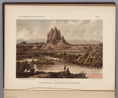
1876 View: Plate X. The Needles, Looking Sout … Exploration Book (View) Plate X. The Needles, Looking Sou … |

1876 View: Plate XI. The Cabazon from near Ca … Exploration Book (View) Plate XI. The Cabazon from near C … |

1876 Text and View: Plate I. Cretaceous Fossi … Exploration Book (Text and View) Plate I. Cretaceous Foss … |

1876 Text and View: Plate II. Cretaceous Foss … Exploration Book (Text and View) Plate II. Cretaceous Fos … |

1876 Text and View: Plate III. Carboniferous … Exploration Book (Text and View) Plate III. Carboniferous … |

1876 Text and View: Plate IV. (Carboniferous … Exploration Book (Text and View) Plate IV. (Carboniferous … |

1876 Text and View: Plate V. (Carboniferous & … Exploration Book (Text and View) Plate V. (Carboniferous … |

1876 Text and View: Plate VI. (Carboniferous … Exploration Book (Text and View) Plate VI. (Carboniferous … |

1876 Text and View: Plate VII. (Carboniferous … Exploration Book (Text and View) Plate VII. (Carboniferou … |

1876 Text and View: Plate VIII. (Carboniferou … Exploration Book (Text and View) Plate VIII. (Carbonifero … |

1876 A Plan Of The Property Of The Hampton No … Separate Map A Plan Of The Property Of The Hampton No … |

1876 State Of Texas. Pocket Map Map of the state of Texas. Woodward, Tie … |

1876 Covers: An Illustrated Historical Atlas … County Atlas (Covers to) An Illustrated Historical At … |

1876 Title Page: An Illustrated Historical At … County Atlas (Title Page to) An Illustrated Historica … |

1876 Table of Contents: An Illustrated Histor … County Atlas (Table of Contents to) An Illustrated Hi … |

1876 Western Hemisphere. Eastern Hemisphere. County Atlas Western Hemisphere. Entered ... 1875 by … |

1876 United States and Territories. County Atlas Map of the United States and Territories … |

1876 Text: Statistics of the Population of Da … County Atlas (Text Page) Statistics of the Population … |

1876 County and Road Map of Kentucky. County Atlas County & Road Map of Kentucky Compiled E … |

1876 Text: History Daviess County, Kentucky. County Atlas (Text Page) History Daviess County, Kent … |

1876 Daviess County, Kentucky. County Atlas Map of Daviess County, Ky. Showing preci … |

1876 View: Public Buildings, Daviess County, … County Atlas (View) The Public Buildings, Daviess Cou … |

1876 Text: Precinct History, Daviess County, … County Atlas (Text Page) Precinct History, (Daviess C … |

1876 Boston Precinct No. 5, Daviess County, K … County Atlas Boston Precinct No. 5, (Daviess County, … |

1876 Text: A Portion of our Patrons. County Atlas (Text Page) A Portion of our Patrons. |

1876 Knottsville Precinct No. 4, Daviess Coun … County Atlas Knottsville Precinct No. 4, (Daviess Cou … |

1876 Text: A Portion of our Patrons, continue … County Atlas (Text Page) (A Portion of our Patrons, c … |

1876 Yelvington Precinct No. 3., Daviess Coun … County Atlas Yelvington Precinct No. 3, (Daviess Coun … |

1876 Masonville Precinct No. 10, Daviess Coun … County Atlas Masonville Precinct No. 10, (Daviess Cou … |

1876 Text: A Portion of our Patrons, continue … County Atlas (Text Page) (A Portion of our Patrons, c … |

1876 Murray Precinct No. 6, Daviess County, K … County Atlas Murray Precinct No. 6, (Daviess County, … |

1876 Text: Biographical Sketches of Citizens … County Atlas (Text Page) Biographical Sketches of Cit … |

1876 Uppertown Precinct No. 2, Daviess County … County Atlas Uppertown Precinct No. 2, (Daviess Count … |

1876 Text: Biographical Sketches of Citizens … County Atlas (Text Page) Biographical Sketches of Cit … |

1876 Vanover, Precinct No. 8, Daviess County, … County Atlas Vanover, Precinct No. 8, (Daviess County … |

1876 Oakford, Precinct No. 9, Daviess County, … County Atlas Oakford, Precinct 9, (Daviess County, Ke … |

1876 Text: Biographical Sketches of Citizens … County Atlas (Text Page) Biographical Sketches of Cit … |

1876 Lower Town Precinct No. 1, Daviess Count … County Atlas Lower Town Precinct No. 1, (Daviess Coun … |

1876 Text: Biographical Sketches of Citizens … County Atlas (Text Page) Biographical Sketches of Cit … |

1876 Curdsville Precinct No. 7, Daviess Count … County Atlas Curdsville Precinct 7, (Daviess County, … |

1876 Text: Biographical Sketches of Citizens … County Atlas (Text Page) Biographical Sketches of Cit … |

1876 View: R. Monarch's Distillery, Owensboro … County Atlas (View) R. Monarch's Distillery, Owensbor … |

1876 View: M.V. Monarch's Distillery 1 1/2 Mi … County Atlas (View) M.V. Monarch's Distillery 1 1/2 M … |

1876 Text: Post Offices in the State of Kentu … County Atlas (Text Page) Post Offices in the State of … |