Browse All

1878 XVIII. Nama rothrockii. Exploration Book Nama rothrockii. Sprague del. U.S. Geogr … |

1878 XIX. Gilia. Exploration Book A. Gilia debilis. B. Gilia demissa. Spra … |

1878 XX. Convolvulus longipes. Exploration Book Convolvulus longipes. W.H. Seaman del. U … |

1878 XXI. Halenia rothrockii. Exploration Book Halenia rothrockii. Sprague del. U.S. Ge … |

1878 XXII. Fraxinus coriacea. Exploration Book Fraxinus coriacea. Sprague del. U.S. Geo … |

1878 XXIII. Abronia villosa. Exploration Book Abronia villosa. W.H. Seaman del. U.S. G … |

1878 XXIV. Atriplex wolfii. Exploration Book Artiplex wolfii (i.e. Atriplex wolfii). … |

1878 XXV. Urtica breweri. Exploration Book Urtica breweri. Sprague del. U.S. Geogra … |

1878 XXVI. Sisyrhinchium arizonicum. Exploration Book Sisyrhinchium arizonicum. Sprague del. U … |

1878 XXVII. Trisetum, Vilfa. Exploration Book Figs. 1-3. Trisetum wolfii. Figs. 4-6. T … |

1878 XXVIII. Poa wheeleri. Exploration Book Poa wheeleri. W.H. Seaman del. U.S. Geog … |

1878 XXIX. Festuca thurberi. Exploration Book Festuca thurberi. W.H. Seaman del. U.S. … |

1878 XXX. Notholaena hookeri. Exploration Book Notholaena hookeri. Sprague del. U.S. Ge … |

1878 61D. Part Of South Western Colorado. National Atlas Part Of South Western Colorado, Atlas Sh … |

1878 61C. Part Of Southwestern Colorado. National Atlas Part Of Southwestern Colorado, Atlas She … |

1878 61C. Land Classification Map Of Part Of … National Atlas Land Classification Map Of Part Of South … |

1838 Warren County, Pennsylvania, By Andrew H … County Atlas Map of Warren County, Pennsylvania, By A … |

1876 Covers: Thirty Three Miles Around The Ci … Pocket Map (Covers to) Map Of The Country Thirty Th … |

1876 Thirty Three Miles Around The City Of Ne … Pocket Map Map Of The Country Thirty Three Miles Ar … |

1878 Map of Utah territory : representing the … Exploration Book Map of Utah territory : representing the … |

1878 Map of the United States exhibiting the … Exploration Book Map of the United States exhibiting the … |

1878 41B. North-Eastern Utah & South-Eastern … National Atlas North-Eastern Utah & South-Eastern Idaho … |

1878 41B. Land Classification Map Of North-Ea … National Atlas Land Classification Map Of North-Eastern … |

1878 1878. Progress Map Of The U.S. Geographi … National Atlas 1878 Progress Map Of The U.S. Geographic … |

1878 1878. Progress Map Of The U.S. Geographi … National Atlas 1878, Progress Map Of The U.S. Geographi … |

1878 Louisiana. National Atlas Gray's New Map of Louisiana by Frank A. … |

1878 Spain and Portugal. National Atlas Gray's New Map of Spain and Portugal by … |

1878 Italy. National Atlas Gray's New Map of Italy by Frank A. Gray … |

1878 Australia. National Atlas Gray's New Map of Australia by Frank A. … |

1878 Facsimile: Canada (portion). Historical Atlas (Facsimile) Map of the Dominion of Canad … |

1878 69B. Parts Of South'n Colorado & North'n … National Atlas Parts Of South'n Colorado & North'n New … |

1878 69B. Economic Features Of Parts Of South … National Atlas Economic Features Of Parts Of South'n Co … |

1878 73A. Part Of Southern California. National Atlas Part Of Southern California Atlas Sheet … |

1877 Lexington, Virginia. World Atlas Gray's New Map of Lexington, Rockingham … |
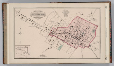
1877 Charlottesville,Virginia. World Atlas Gray's New Map of Charlottesville, Albem … |

1877 Harrisonburg, Virginia. World Atlas Gray's New Map of Harrisonburg, Rockingh … |

1877 Bridgewater, Virginia. World Atlas Gray's New Map of Bridgewater, Rockingha … |

1877 Text Page (1): Professional Directory of … World Atlas (Text Page) The National Atlas. Professi … |

1877 Text Page (2-3): Professional Directory … World Atlas (Text Page) The National Atlas. Professi … |

1877 Text Page (4-5): Professional Directory … World Atlas (Text Page) The National Atlas. Professi … |

1878 77D. Central New Mexico. National Atlas Central New Mexico, Atlas-Sheet No. 77(D … |

1878 77D. Land Classification Map Of Part Of … National Atlas Land Classification Map Of Part Of Centr … |