Who What Where WhenREMOVEWHAT
WHEREShow More |
Author
[Geological Survey (U.S.), Massachusetts. Topographical Survey Commission]
Full Title
Massachusetts. Boston sheet. Preliminary edition subject to corrections. U.S. Geological Survey, J.W. Powell, Director. State of Massachusetts ... commissioners. Henry Gannett, Chief Geographer. Marcus Baker, geographer in charge. Triangulation by the U.S. Coast and Geodetic and Borden surveys. Topography by E.W.F. Natter. J.H. Jennings, assistant. Surveyed in 1885-6. Forbes Co., Boston & N.Y. (1890)
Publisher
Topographical Survey Commission
Author
[Geological Survey (U.S.), Massachusetts. Topographical Survey Commission]
Full Title
Massachusetts. Dedham sheet. Preliminary edition subject to corrections. U.S. Geological Survey, J.W. Powell, Director. State of Massachusetts ... commissioners. Henry Gannett, Chief Geographer. Marcus Baker, geographer in charge. Triangulation by the U.S. Coast and Geodetic and Borden surveys. Topography by S.H. Bodfish and E.W.F. Natter. Surveyed in 1884-86. Forbes Co., Boston & N.Y. (1890)
Publisher
Topographical Survey Commission
Author
[Geological Survey (U.S.), Massachusetts. Topographical Survey Commission]
Full Title
Massachusetts. Taunton sheet. Preliminary edition subject to corrections. U.S. Geological Survey, J.W. Powell, Director. State of Massachusetts ... commissioners. Henry Gannett, Chief Geographer. Triangulation by the U.S. Coast and Geodetic and Borden surveys. Topography by Sumner H. Bodfish, topographer. Surveyed in 1885. Forbes Co., Boston & N.Y. (1890)
Publisher
Topographical Survey Commission
Author
[Geological Survey (U.S.), Massachusetts. Topographical Survey Commission]
Full Title
Mass.-R.I. Fall River sheet. Preliminary edition subject to corrections. U.S. Geological Survey, J.W. Powell, Director. State of Rhode Island ... State of Massachusetts ... commissioners. Henry Gannett, Chief Geographer. Triangulation by the U.S. Coast and Geodetic and Borden surveys. Coast line by U.S. Coast and Geodetic Survey. Topography bordering Mt. Hope Bay and Sakonnet River by the U.S. Coast and Geodetic Survey. Topography by Sumner H. Bodfish, topographer. Surveyed in 1885. Forbes Co., Boston & N.Y. (1890)
Publisher
Topographical Survey Commission
Author
[Geological Survey (U.S.), Massachusetts. Topographical Survey Commission]
Full Title
Rhode Island. Sakonnet sheet. Preliminary edition subject to corrections. U.S. Geological Survey, J.W. Powell, Director. State of Rhode Island ... commissioners. Triangulation and topography by the U.S. Coast and Geodetic Survey. Surveyed in 1885. Forbes Co., Boston & N.Y. (1890)
Publisher
Topographical Survey Commission
Author
[Geological Survey (U.S.), Massachusetts. Topographical Survey Commission]
Full Title
Massachusetts-New Hampshire. Newburyport sheet. Preliminary edition subject to corrections. U.S. Geological Survey, J.W. Powell, Director. State of Massachusetts ... commissioners. Henry Gannett, Chief Geographer. Marcus Baker, geographer in charge. Triangulation by the U.S. Coast and Geodetic and Borden surveys. Coast line by U.S. Coast and Geodetic Survey. Topography by J.D. Hoffman (i.e. Hoffmann) and W.H. Lovell. Surveyed in 1884-8. Forbes Co., Boston & N.Y. (1890)
Publisher
Topographical Survey Commission
Author
[Geological Survey (U.S.), Massachusetts. Topographical Survey Commission]
Full Title
Massachusetts. Salem sheet. Preliminary edition subject to corrections. U.S. Geological Survey, J.W. Powell, Director. State of Massachusetts ... commissioners. Henry Gannett, Chief Geographer. Marcus Baker, geographer in charge. Triangulation by the U.S. Coast and Geodetic and Borden surveys. Coast line by the U.S. Coast and Geodetic Survey. Topography by E.W.F. Natter. Surveyed in 1886. Forbes Co., Boston & N.Y. (1890)
Publisher
Topographical Survey Commission
Author
[Geological Survey (U.S.), Massachusetts. Topographical Survey Commission]
Full Title
Massachusetts. Boston Bay sheet. Preliminary edition subject to corrections. U.S. Geological Survey, J.W. Powell, Director. State of Massachusetts ... commissioners. Henry Gannett, Chief Geographer. Marcus Baker, geographer in charge. Triangulation by the U.S. Coast and Geodetic and Borden surveys. Coast line by the U.S. Coast and Geodetic Survey. E.W.F. Natter, topographer in charge. Wm. Kramer, J.H. Jennings, assistants. Surveyed in 1886-7. Forbes Co., Boston & N.Y. (1890)
Publisher
Topographical Survey Commission
Author
[Geological Survey (U.S.), Massachusetts. Topographical Survey Commission]
Full Title
Massachusetts. Abington sheet. Preliminary edition subject to corrections. U.S. Geological Survey, J.W. Powell, Director. State of Massachusetts ... commissioners. Henry Gannett, Chief Geographer. Triangulation by the U.S. Coast and Geodetic and Borden surveys. Topography by Sumner H. Bodfish. Surveyed in 1885. Forbes Co., Boston & N.Y. (1890)
Publisher
Topographical Survey Commission
Author
[Geological Survey (U.S.), Massachusetts. Topographical Survey Commission]
Full Title
Massachusetts. Middleborough sheet. Preliminary edition subject to corrections. U.S. Geological Survey, J.W. Powell, Director. State of Massachusetts ... commissioners. Henry Gannett, Chief Geographer. Triangulation by the U.S. Coast and Geodetic and Borden surveys. Topography by Sumner H. Bodfish, topographer in charge, assisted by Laurence Thompson, Henry Lloyd Smyth, W.J. Grambs & R.H. Philips, assistants. Surveyed in 1885. Forbes Co., Boston & N.Y. (1890)
Publisher
Topographical Survey Commission
Author
[Geological Survey (U.S.), Massachusetts. Topographical Survey Commission]
Full Title
Massachusetts. New Bedford sheet. Preliminary edition subject to corrections. U.S. Geological Survey, J.W. Powell, Director. State of Massachusetts ... commissioners. Henry Gannett, Chief Geographer. Triangulation by the U.S. Coast and Geodetic and Borden surveys. Coast line by the U.S. Coast and Geodetic Survey. Sumner H. Bodfish, topographer in charge. Henry Lloyd Smith and W.J. Grambs, assistants. Surveyed in 1885. Forbes Co., Boston & N.Y. (1890)
Publisher
Topographical Survey Commission
Author
[Geological Survey (U.S.), Massachusetts. Topographical Survey Commission]
Full Title
Massachusetts. Gay Head sheet. Preliminary edition subject to corrections. U.S. Geological Survey, J.W. Powell, Director. State of Massachusetts ... commissioners. Henry Gannett, Chief Geographer. Marcus Baker, geographer in charge. Triangulation and coast line by the U.S. Coast and Geodetic Survey. Topography by E.B. Clark. Surveyed in 1887. Forbes Co., Boston & N.Y. (1890)
Publisher
Topographical Survey Commission
Author
[Geological Survey (U.S.), Massachusetts. Topographical Survey Commission]
Full Title
Massachusetts. Gloucester sheet. Preliminary edition subject to corrections. U.S. Geological Survey, J.W. Powell, Director. State of Massachusetts ... commissioners. Henry Gannett, Chief Geographer. Marcus Baker, geographer in charge. Triangulation and coast line by the U.S. Coast and Geodetic and Borden surveys. Topography by E.W.F. Natter. Surveyed in 1886. Forbes Co., Boston & N.Y. (1890)
Publisher
Topographical Survey Commission
Author
[Geological Survey (U.S.), Massachusetts. Topographical Survey Commission]
Full Title
Massachusetts. Duxbury sheet. Preliminary edition subject to corrections. U.S. Geological Survey, J.W. Powell, Director. State of Massachusetts ... commissioners. Henry Gannett, Chief Geographer. Triangulation by the U.S. Coast and Geodetic Survey and Borden Survey. Topography of the coast by the U.S. Coast and Geodetic Survey. Topography by W.J. Grambs. Sumner H. Bodfish, topographer in charge. Surveyed in 1885. Forbes Co., Boston & N.Y. (1890)
Publisher
Topographical Survey Commission
Author
[Geological Survey (U.S.), Massachusetts. Topographical Survey Commission]
Full Title
Massachusetts. Plymouth sheet. Preliminary edition subject to corrections. U.S. Geological Survey, J.W. Powell, Director. State of Massachusetts ... commissioners. Henry Gannett, Chief Geographer. Marcus Baker, geographer in charge. Triangulation and topography of the coast by the U.S. Coast and Geodetic Survey. Topography by W.J. Grambs, H.L. Smyth, and L. Thompson, under the direction of Sumner H. Bodfish. Surveyed in 1885-6. Forbes Co., Boston & N.Y. (1890)
Publisher
Topographical Survey Commission
Author
[Geological Survey (U.S.), Massachusetts. Topographical Survey Commission]
Full Title
Massachusetts. Falmouth sheet. Preliminary edition subject to corrections. U.S. Geological Survey, J.W. Powell, Director. State of Massachusetts ... commissioners. Henry Gannett, Chief Geographer. Marcus Baker, geographer in charge. Triangulation by the U.S. Coast and Geodetic and Borden surveys. Coast line by the U.S. Coast and Geodetic Survey. Topography by W.J. Crambs (i.e. Grambs), assistant, under the direction of Sumner H. Bodfish, topographer. Surveyed in 1886. Forbes Co., Boston & N.Y. (1890)
Publisher
Topographical Survey Commission
Author
[Geological Survey (U.S.), Massachusetts. Topographical Survey Commission]
Full Title
Massachusetts. Martha's Vineyard sheet. Preliminary edition subject to corrections. U.S. Geological Survey, J.W. Powell, Director. State of Massachusetts ... commissioners. Henry Gannett, Chief Geographer. Marcus Baker, geographer in charge. Triangulation and coast line by the U.S. Coast and Geodetic Survey. Topography by E.B. Clark. Surveyed in 1887. Forbes Co., Boston & N.Y. (1890)
Publisher
Topographical Survey Commission
Author
[Geological Survey (U.S.), Massachusetts. Topographical Survey Commission]
Full Title
Massachusetts. Barnstable sheet. Preliminary edition subject to corrections. U.S. Geological Survey, J.W. Powell, Director. State of Massachusetts ... commissioners. Henry Gannett, Chief Geographer. Marcus Baker, geographer in charge. Triangulation, coast line and topography of north coast by the U.S. Coast and Geodetic Survey, the remainder by E.B. Clark, assistant topographer. Forbes Co., Boston & N.Y. (1890)
Publisher
Topographical Survey Commission
Author
[Geological Survey (U.S.), Massachusetts. Topographical Survey Commission]
Full Title
Massachusetts. Muskeget sheet. Preliminary edition subject to corrections. U.S. Geological Survey, J.W. Powell, Director. State of Massachusetts ... commissioners. Henry Gannett, Chief Geographer. Marcus Baker, geographer in charge. Triangulation and coast line by the U.S. Coast and Geodetic Survey. Topography by E.B. Clark. Surveyed in 1887. Forbes Co., Boston & N.Y. (1890)
Publisher
Topographical Survey Commission
Author
[Geological Survey (U.S.), Massachusetts. Topographical Survey Commission]
Full Title
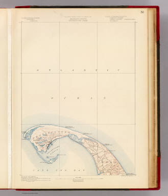
Massachusetts. Provincetown sheet. Preliminary edition subject to corrections. U.S. Geological Survey, J.W. Powell, Director. State of Massachusetts ... commissioners. Henry Gannett, Chief Geographer. Marcus Baker, geographer in charge. Triangulation by the U.S. Coast and Geodetic and Borden surveys. Coast line by the U.S. Coast Survey. Topography by the U.S. Geological Survey and U.S. Coast Survey. Surveyed in 1887. Forbes Co., Boston & N.Y. (1890)
Publisher
Topographical Survey Commission
Author
[Geological Survey (U.S.), Massachusetts. Topographical Survey Commission]
Full Title
Massachusetts. Wellfleet sheet. Preliminary edition subject to corrections. U.S. Geological Survey, J.W. Powell, Director. State of Massachusetts ... commissioners. Henry Gannett, Chief Geographer. Marcus Baker, geographer in charge. Triangulation by the U.S. Coast and Geodetic Survey. Topography by the U.S. Coast and Geodetic Survey and by E.B. Clark. Surveyed in 1887. Forbes Co., Boston & N.Y. (1890)
Publisher
Topographical Survey Commission
Author
[Geological Survey (U.S.), Massachusetts. Topographical Survey Commission]
Full Title
Massachusetts. Yarmouth sheet. Preliminary edition subject to corrections. U.S. Geological Survey, J.W. Powell, Director. State of Massachusetts ... commissioners. Henry Gannett, Chief Geographer. Marcus Baker, geographer in charge. Triangulation and coast line by the U.S. Coast and Geodetic Survey. Topography by E.B. Clark. Surveyed in 1886-7. Forbes Co., Boston & N.Y. (1890)
Publisher
Topographical Survey Commission
Author
[Geological Survey (U.S.), Massachusetts. Topographical Survey Commission]
Full Title
Massachusetts. Nantucket sheet. Preliminary edition subject to corrections. U.S. Geological Survey, J.W. Powell, Director. State of Massachusetts ... commissioners. Henry Gannett, Chief Geographer. Marcus Baker, geographer in charge. Triangulation and coast line by the U.S. Coast and Geodetic Survey. Topography by E.B. Clark, assistant topographer. Surveyed in 1887. Forbes Co., Boston & N.Y. (1890)
Publisher
Topographical Survey Commission
Author
[Geological Survey (U.S.), Massachusetts. Topographical Survey Commission]
Full Title
Massachusetts. Chatham sheet. Preliminary edition subject to corrections. U.S. Geological Survey, J.W. Powell, Director. State of Massachusetts ... commissioners. Henry Gannett, Chief Geographer. Marcus Baker, geographer in charge. Compiled chiefly from U.S. Coast and Geodetic Survey. Forbes Co., Boston & N.Y. (1890)
Publisher
Topographical Survey Commission
Author
[Bouve, Crawford & Co., Good, Charles E.]
Full Title
Correct map of Boston Harbor giving route and official summer time-table of the Nantasket Beach Steamboat Co. Compliments of Bouve, Crawford & Co., Boston, makers of the celebrated Craword Shoe and proprietors of twenty Crawford shoe stores. Office: 611 Washington St, Boston. Published by Bouve, Crawford & Co. ... Copyrighted by Bouve, Crawford & Co., June 7th, 1890.
Publisher
Bouve, Crawford & Co.
Author
[Bouve, Crawford & Co., Good, Charles E.]
Full Title
(Covers to) Correct map of Boston Harbor giving route and official summer time-table of the Nantasket Beach Steamboat Co. Compliments of Bouve, Crawford & Co., Boston, makers of the celebrated Craword Shoe and proprietors of twenty Crawford shoe stores. Office: 611 Washington St, Boston. Published by Bouve, Crawford & Co. ... Copyrighted by Bouve, Crawford & Co., June 7th, 1890.
Publisher
Bouve, Crawford & Co.
Author
[Bouve, Crawford & Co., Good, Charles E.]
Full Title
(Verso of) Correct map of Boston Harbor giving route and official summer time-table of the Nantasket Beach Steamboat Co. Compliments of Bouve, Crawford & Co., Boston, makers of the celebrated Craword Shoe and proprietors of twenty Crawford shoe stores. Office: 611 Washington St, Boston. Published by Bouve, Crawford & Co. ... Copyrighted by Bouve, Crawford & Co., June 7th, 1890.
Publisher
Bouve, Crawford & Co.
Author
E.P. Noll & Co.
Full Title
(Covers to) Noll's New Official Guide Map Of Philadelphia From The Latest Official Surveys & Records ... 1890. Published By E.P. Noll & Co. Map Publishers & Mounters 17 North Sixth Street Philadelphia, Pa. Entered ... 1889, by E.P Noll & Co. ... Washington D.C.
Publisher
E.P. Noll & Co.
Author
E.P. Noll & Co.
Full Title
Noll's New Official Guide Map Of Philadelphia From The Latest Official Surveys & Records ... 1890. Published By E.P. Noll & Co. Map Publishers & Mounters 17 North Sixth Street Philadelphia, Pa. Entered ... 1889, by E.P Noll & Co. ... Washington D.C.
Publisher
E.P. Noll & Co.
Author
Boston and Maine Railroad
Full Title
(Covers to) Map of Mount Desert Island And The Coast Of Maine. Issued By Passenger Department Of Boston & Maine Railroad. Rand Avery Supply Co., Engs., Boston.
Publisher
Rand Avery Supply Co.
Author
Boston and Maine Railroad
Full Title
Map of Mount Desert Island And The Coast Of Maine. Issued By Passenger Department Of Boston & Maine Railroad. Rand Avery Supply Co., Engs., Boston.
Publisher
Rand Avery Supply Co.
Author
[Colton, G.W. & C.B., Ely, W.W., Wallace, Edwin R.]
Full Title
(Covers to) Colton's Map Of The New York Wilderness And The Adirondacks. Compiled By W.W. Ely, M.D.; Revised By Edwin R. Wallace. Engraved, Printed and Published By G.W. & C.B. Colton & Co. No. 312 Broadway New York. 1890. Entered ... 1881 by G.W. & C.B. Colton & Co. ... Washington. (untitled inset of the New York State and New England states).
Publisher
G.W. & C.B. Colton & Co.
Author
[Colton, G.W. & C.B., Ely, W.W., Wallace, Edwin R.]
Full Title
Colton's Map Of The New York Wilderness And The Adirondacks. Compiled By W.W. Ely, M.D.; Revised By Edwin R. Wallace. Engraved, Printed and Published By G.W. & C.B. Colton & Co. No. 312 Broadway New York. 1890. Entered ... 1881 by G.W. & C.B. Colton & Co. ... Washington. (untitled inset of the New York State and New England states).
Publisher
G.W. & C.B. Colton & Co.
Author
Colton, G.W. & C.B.
Full Title
(Covers to) Colton's New Township Map of The Eastern Counties Of Pennsylvania. G.W. & C.B. Colton & Co., 182 William St. New York 1890. Entered ... 1865, by G.W. & C.B. Colton ... New York.
Publisher
G.W. & C.B. Colton & Co.
Author
Colton, G.W. & C.B.
Full Title
Colton's New Township Map of The Eastern Counties Of Pennsylvania. G.W. & C.B. Colton & Co., 182 William St. New York 1890. Entered ... 1865, by G.W. & C.B. Colton ... New York.
Publisher
G.W. & C.B. Colton & Co.
Author
Norton, J.A.
Full Title
(Covers to) Railroad Map Of Ohio. Published By The State. 1890. Prepared By J.A. Norton, Commissioner of Railroads & Telegraphs. Columbus, Ohio. H.B. Stranahan & Co. Map Engravers & Publishers, Cleveland, Ohio. Copyright 1890 by H.B. Stranahan.
Publisher
State of Ohio
Author
Norton, J.A.
Full Title
Railroad Map Of Ohio. Published By The State. 1890. Prepared By J.A. Norton, Commissioner of Railroads & Telegraphs. Columbus, Ohio. H.B. Stranahan & Co. Map Engravers & Publishers, Cleveland, Ohio. Copyright 1890 by H.B. Stranahan.
Publisher
State of Ohio
Author
[Foote, C.M., Henion, J.W.]
Full Title
(Covers) Plat Book Of Columbia County Wisconsin. Drawn from actual Surveys and the County records by C.M. Foote & J.W. Henion, Surveyors And Draughtsmen. Published By C.M. Foote & Co. 309 Nicollet Avenue. Minneapolis, Minn. 1890. Eng. by Wm. Bracher, 27 So. 6th St. Philad. Printed by F. Bourquin, 31 So. Sixth St. Phila.
Publisher
C.M. Foote & Co.
Author
[Foote, C.M., Henion, J.W.]
Full Title
(Title Page) Plat Book Of Columbia County Wisconsin. Drawn from actual Surveys and the County records by C.M. Foote & J.W. Henion, Surveyors And Draughtsmen. Published By C.M. Foote & Co. 309 Nicollet Avenue. Minneapolis, Minn. 1890. Eng. by Wm. Bracher, 27 So. 6th St. Philad. Printed by F. Bourquin, 31 So. Sixth St. Phila.
Publisher
C.M. Foote & Co.
Author
[Foote, C.M., Henion, J.W.]
Full Title
(Table of Contents to) Plat Book Of Columbia County Wisconsin. Drawn from actual Surveys and the County records by C.M. Foote & J.W. Henion, Surveyors And Draughtsmen. Published By C.M. Foote & Co. 309 Nicollet Avenue. Minneapolis, Minn. 1890. Eng. by Wm. Bracher, 27 So. 6th St. Philad. Printed by F. Bourquin, 31 So. Sixth St. Phila.
Publisher
C.M. Foote & Co.
Author
[Foote, C.M., Henion, J.W.]
Full Title
(Text Page) Government Surveys.
Publisher
C.M. Foote & Co.
Author
[Foote, C.M., Henion, J.W.]
Full Title
Outline Map of Columbia Co., Wisconsin.
Publisher
C.M. Foote & Co.
Author
[Foote, C.M., Henion, J.W.]
Full Title
Wisconsin.
Publisher
C.M. Foote & Co.
Author
[Foote, C.M., Henion, J.W.]
Full Title
Plat of Randolph, Township 13 North, Range 12 East of the Fourth Principal Meridian, Columbia Co., Wisconsin.
Publisher
C.M. Foote & Co.
Author
[Foote, C.M., Henion, J.W.]
Full Title
Randolph, Westford Twp. Dekorra. Rio, Otsego Tp. Okee, Lodi Twp.
Publisher
C.M. Foote & Co.
Author
[Foote, C.M., Henion, J.W.]
Full Title
Plat of Scott Township 13 North, Range 11 East of the Fourth Principal Meridian, Columbia Co., Wis.
Publisher
C.M. Foote & Co.
Author
[Foote, C.M., Henion, J.W.]
Full Title
Plat of Marcellon, Township 13 North, Range 10 East of the Fourth Principal Meridian, Columbia Co., Wis.
Publisher
C.M. Foote & Co.
Author
[Foote, C.M., Henion, J.W.]
Full Title
Plat of Fort Winnebago, Township 13 North, Range 9 East of the Fourth Principal Meridian, Columbia Co., Wis.
Publisher
C.M. Foote & Co.
Author
[Foote, C.M., Henion, J.W.]
Full Title
Wyocena. Doylestown. Otsego. Arlington.
Publisher
C.M. Foote & Co.
Author
[Foote, C.M., Henion, J.W.]
Full Title
Plat of Lewiston, Townships 12-13 North, Ranges 7-8 East of Fourth Principal Meridian, Columbia Co., Wis. Poynette, Dekorra Twp.
Publisher
C.M. Foote & Co.
|