Who What Where WhenREMOVEWHATShow More |
Title
The Judgment of Paris (Judgement de Paris)
Description
null
Date
1915
Title
[Harry Marks Of The Band Very Drunk With Pinned-On Iron Cross Spring 1915, Billets In Church Walls Llanddudno, PA-F06101-0053: Harry Marks Of The Band Very Drunk With Pinned-On Iron Cross Spring 1915, Billets In Church Walls Llanddudno]
Artist / Maker / Culture
David Jones
Date
1915
Title
[John Charles Wynne Finch Of Voelas M. C. , D. L., PA-F05173-0003: John Charles Wynne Finch Of Voelas M. C. , D. L.]
Artist / Maker / Culture
Alfred Jonniaux
Date
1915
Title
[Soldier Lying - (Salisbury Plain - At Musketry Course - Autumn 1915, PA-F06157-0115: Soldier Lying - (Salisbury Plain - At Musketry Course - Autumn 1915]
Artist / Maker / Culture
David Jones
Date
1915
Author
Kenyon Company
Full Title
(Covers to) Map Of Minnesota. The Red Lines show the Congressional Districts With Latest Official Census. Copyrighted 1913. The Kenyon Company Map Makers, Des Moines, Iowa. C.E. Brown Land Co. Improved Southern Minnesota Farms Lands Established 1902 ... Farm Loans and Insurance, Write Us for our list of Southern Minnesota Lands. C.E. Brown Land Co., Home Office, Madelia, Minn. Branch Office, New Ulm, Minn.
Publisher
The Kenyon Company
Author
Kenyon Company
Full Title
(Text Page to) Map Of Minnesota. The Red Lines show the Congressional Districts With Latest Official Census. Copyrighted 1913. The Kenyon Company Map Makers, Des Moines, Iowa. C.E. Brown Land Co. Improved Southern Minnesota Farms Lands Established 1902 ... Farm Loans and Insurance, Write Us for our list of Southern Minnesota Lands. C.E. Brown Land Co., Home Office, Madelia, Minn. Branch Office, New Ulm, Minn.
Publisher
The Kenyon Company
Author
Kenyon Company
Full Title
Map Of Minnesota. The Red Lines show the Congressional Districts With Latest Official Census. Copyrighted 1913. The Kenyon Company Map Makers, Des Moines, Iowa. C.E. Brown Land Co. Improved Southern Minnesota Farms Lands Established 1902 ... Farm Loans and Insurance, Write Us for our list of Southern Minnesota Lands. C.E. Brown Land Co., Home Office, Madelia, Minn. Branch Office, New Ulm, Minn.
Publisher
The Kenyon Company
Author
Geographical Publishing Company
Full Title
Wayne Co. Indiana. Copyrighted 1915 by The Geographical Publ. Co. Chicago.
Publisher
The Geographical Publishing Company
Author
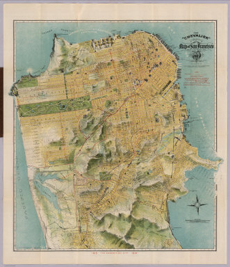
Chevalier, August
Full Title
(Covers to) The "Chevalier" Commercial, Pictorial and Tourist Map of San Francisco From Latest U.S. Gov. and Official Surveys. Designed-Engraved And Copyrighted By Aug. Chevalier, Lithographer Publisher, 507 Mission St. San Francisco ... The Exposition City 1915. Copyrighted 1912 By Aug. Chevalier ... (on verso) An index to the street and text.
Publisher
August Chevalier
Author
Chevalier, August
Full Title
The "Chevalier" Commercial, Pictorial and Tourist Map of San Francisco From Latest U.S. Gov. and Official Surveys. Designed-Engraved And Copyrighted By Aug. Chevalier, Lithographer Publisher, 507 Mission St. San Francisco ... The Exposition City 1915. Copyrighted 1912 By Aug. Chevalier ... (on verso) Untitled index to the street, parks, Public Schools ... of San Francisco.
Publisher
August Chevalier
Author
Chevalier, August
Full Title
(Index Page to) Untitled index to the Street, parks, Public Schools ... of San Francisco. (on verso) The "Chevalier" Commercial, Pictorial and Tourist Map of San Francisco From Latest U.S. Gov. and Official Surveys. Designed-Engraved And Copyrighted By Aug. Chevalier, Lithographer Publisher, 507 Mission St. San Francisco ... The Exposition City 1915. Copyrighted 1912 By Aug. Chevalier ...
Publisher
August Chevalier
Author
Maduro Jr., I.L.
Full Title
(Covers to) Bird's Eye View of the Panama Canal and Map of Panama. I.L. Maduro Jr, Panama.
Publisher
I.L. Maduro Jr.,
Author
Maduro Jr., I.L.
Full Title
(Text Page) (Panama Canal Photographs and Descriptions).
Publisher
I.L. Maduro Jr.,
Author
Maduro Jr., I.L.
Full Title
Profile of Panama Canal. Bird's Eye View of the Panama Canal. Map of Panama. I.L. Maduro Jr, Panama.
Publisher
I.L. Maduro Jr.,
Author
Ogle, George A. & Co.
Full Title
(Covers to) Standard Atlas Of Douglas County Washington. Including A Plat Book Of The Villages, Cities And Townships Of The County ... Compiled and Published By Geo. A. Ogle & Co. Publishers & Engravers. Chicago. 1915. Copyright 1915 by Geo. A. Ogle & Co.
Publisher
Geo. A. Ogle & Co.
Author
Ogle, George A. & Co.
Full Title
(Title Page to) Standard Atlas Of Douglas County Washington. Including A Plat Book Of The Villages, Cities And Townships Of The County ... Compiled and Published By Geo. A. Ogle & Co. Publishers & Engravers. Chicago. 1915. Copyright 1915 by Geo. A. Ogle & Co.
Publisher
Geo. A. Ogle & Co.
Author
Ogle, George A. & Co.
Full Title
(Index Page) Table of Contents. General Index. Douglas County Index.
Publisher
Geo. A. Ogle & Co.
Author
Ogle, George A. & Co.
Full Title
(Index Page) Index to Illustrations.
Publisher
Geo. A. Ogle & Co.
Author
Ogle, George A. & Co.
Full Title
(Index Map) Index Map of Douglas County, Washington.
Publisher
Geo. A. Ogle & Co.
Author
Ogle, George A. & Co.
Full Title
Outline Map of Douglas County, Washington.
Publisher
Geo. A. Ogle & Co.
Author
Ogle, George A. & Co.
Full Title
Mansfield.
Publisher
Geo. A. Ogle & Co.
Author
Ogle, George A. & Co.
Full Title
Waterville.
Publisher
Geo. A. Ogle & Co.
Author
Ogle, George A. & Co.
Full Title
Orondo and Fisher Orchard Tracks.
Publisher
Geo. A. Ogle & Co.
Author
Ogle, George A. & Co.
Full Title
Trinidad.
Publisher
Geo. A. Ogle & Co.
Author
Ogle, George A. & Co.
Full Title
Bridgeport.
Publisher
Geo. A. Ogle & Co.
Author
Ogle, George A. & Co.
Full Title
Moses Coulee Fruit Land Co's Orchard Plat No. 1. MacLean's Orchard Tract.
Publisher
Geo. A. Ogle & Co.
Author
Ogle, George A. & Co.
Full Title
Palisades. Withrow. Columbia River (Subdivision).
Publisher
Geo. A. Ogle & Co.
Author
Ogle, George A. & Co.
Full Title
East Wenatchee Land Co's. Plats. Part of Township 20 N., Range 22 E. Part of Township 21 N., Ranges 22 and 23 E.
Publisher
Geo. A. Ogle & Co.
Author
Ogle, George A. & Co.
Full Title
Map of Township 22 N., Ranges 20 and 21 E.
Publisher
Geo. A. Ogle & Co.
Author
Ogle, George A. & Co.
Full Title
Part of Township 22 N., Range 22 E.
Publisher
Geo. A. Ogle & Co.
Author
Ogle, George A. & Co.
Full Title
Map of Part of Township 22 N., Range 23 E.
Publisher
Geo. A. Ogle & Co.
Author
Ogle, George A. & Co.
Full Title
Map of Township 22 N., Range 32 E. and Part of Township 23 N., Range 20 E.
Publisher
Geo. A. Ogle & Co.
Author
Ogle, George A. & Co.
Full Title
Map of Township 23 N., Range 22 E.
Publisher
Geo. A. Ogle & Co.
Author
Ogle, George A. & Co.
Full Title
Map of Township 23 N., Range 23 E.
Publisher
Geo. A. Ogle & Co.
Author
Ogle, George A. & Co.
Full Title
Map of Township 23 N., Range 24 E.
Publisher
Geo. A. Ogle & Co.
Author
Ogle, George A. & Co.
Full Title
Map of Township 23 N., Range 25 E.
Publisher
Geo. A. Ogle & Co.
Author
Ogle, George A. & Co.
Full Title
Map of Part of Township 23 N., Range 26 E. Wenachee Chelan Orchard Co's. Land.
Publisher
Geo. A. Ogle & Co.
Author
Ogle, George A. & Co.
Full Title
Map of Part of Township 24 N., Ranges 20 and 21 E.
Publisher
Geo. A. Ogle & Co.
Author
Ogle, George A. & Co.
Full Title
Map of Township 24 N., Range 22 E.
Publisher
Geo. A. Ogle & Co.
Author
Ogle, George A. & Co.
Full Title
Map of Township 24 N., Range 23 E.
Publisher
Geo. A. Ogle & Co.
Author
Ogle, George A. & Co.
Full Title
Map of Township 24 N., Range 24 E.
Publisher
Geo. A. Ogle & Co.
Author
Ogle, George A. & Co.
Full Title
Map of Township 24 N., Range 25 E.
Publisher
Geo. A. Ogle & Co.
|


![[Harry Marks Of The Band Very Drunk With Pinned-On Iron Cross Spring 1915, Billets In Church Walls Llanddudno, PA-F06101-0053: Harry Marks Of The Band Very Drunk With Pinned-On Iron Cross Spring 1915, Billets In Church Walls Llanddudno]](https://photoarchive.paul-mellon-centre.ac.uk/apis/iiif/image/v2/243235/full/483,/0/default.jpg)
![[John Charles Wynne Finch Of Voelas M. C. , D. L., PA-F05173-0003: John Charles Wynne Finch Of Voelas M. C. , D. L.]](https://photoarchive.paul-mellon-centre.ac.uk/apis/iiif/image/v2/235557/full/610,/0/default.jpg)
![[Soldier Lying - (Salisbury Plain - At Musketry Course - Autumn 1915, PA-F06157-0115: Soldier Lying - (Salisbury Plain - At Musketry Course - Autumn 1915]](https://photoarchive.paul-mellon-centre.ac.uk/apis/iiif/image/v2/281147/full/768,/0/default.jpg)