Browse All

1915 Enchanted Woods |

1915 Island of Laputa |

1915 The Judgment of Paris (Judgement de Pari … |

1915 The Swan |

1915 Standing Nude |

1915 Sixteen Rakan |

1915 Dalaro |

1915 The Ford |

1915 [Harry Marks Of The Band Very Drunk With David Jones |

1915 [John Charles Wynne Finch Of Voelas M. C Alfred Jonniaux |

1915 [Soldier Lying - (Salisbury Plain - At M David Jones |

1915 Covers: Map Of Minnesota Pocket Map (Covers to) Map Of Minnesota. The Red Li … |

1915 Text Page: Map Of Minnesota Pocket Map (Text Page to) Map Of Minnesota. The Red … |

1915 Map Of Minnesota Pocket Map Map Of Minnesota. The Red Lines show the … |

1915 Wayne Co. Indiana Separate Map Wayne Co. Indiana. Copyrighted 1915 by T … |

1915 Covers: The "Chevalier" Commercial, Pict … Pocket Map (Covers to) The "Chevalier" Commercial, … |
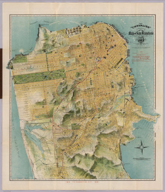
1915 The "Chevalier" Commercial, Pictorial an … Pocket Map The "Chevalier" Commercial, Pictorial an … |

1915 Index Page: The "Chevalier" Commercial, … Pocket Map (Index Page to) Untitled index to the St … |

1915 Covers: Bird's Eye View of the Panama Ca … Separate Map (Covers to) Bird's Eye View of the Panam … |

1915 Text: Panama Canal Photographs and Descr … Separate Map (Text Page) (Panama Canal Photographs an … |

1915 Profile of Panama Canal. Bird's Eye View … Separate Map Profile of Panama Canal. Bird's Eye View … |

1915 Covers: Standard Atlas Of Douglas County … County Atlas (Covers to) Standard Atlas Of Douglas Co … |

1915 Title: Standard Atlas Of Douglas County … County Atlas (Title Page to) Standard Atlas Of Dougla … |

1915 Index: Table of Contents. General Index. … County Atlas (Index Page) Table of Contents. General … |

1915 Index: Index to Illustrations. County Atlas (Index Page) Index to Illustrations. |

1915 Index Map: Douglas County, Washington. County Atlas (Index Map) Index Map of Douglas County, … |

1915 Douglas County, Washington. County Atlas Outline Map of Douglas County, Washingto … |

1915 Mansfield, Washington. County Atlas Mansfield. |

1915 Waterville, Washington. County Atlas Waterville. |

1915 Orondo and Fisher Orchard Tracks, Washin … County Atlas Orondo and Fisher Orchard Tracks. |

1915 Trinidad, Washington. County Atlas Trinidad. |

1915 Bridgeport, Washington. County Atlas Bridgeport. |

1915 Moses Coulee Fruit Land Co's Orchard Pla … County Atlas Moses Coulee Fruit Land Co's Orchard Pla … |

1915 Palisades. Withrow. Columbia River (Subd … County Atlas Palisades. Withrow. Columbia River (Subd … |

1915 Parts of Townships 20 N., Range 22 E.; T … County Atlas East Wenatchee Land Co's. Plats. Part of … |

1915 Township 22 N., Ranges 20 and 21 E., Dou … County Atlas Map of Township 22 N., Ranges 20 and 21 … |

1915 Township 22 N., Range 22 E., Douglas Cou … County Atlas Part of Township 22 N., Range 22 E. |

1915 Township 22 N., Range 23 E., Douglas Cou … County Atlas Map of Part of Township 22 N., Range 23 … |

1915 Township 22 N., Range 32 E. and Part of … County Atlas Map of Township 22 N., Range 32 E. and P … |

1915 Township 23 N., Range 22 E., Douglas Cou … County Atlas Map of Township 23 N., Range 22 E. |

1915 Township 23 N., Range 23 E., Douglas Cou … County Atlas Map of Township 23 N., Range 23 E. |

1915 Township 23 N., Range 24 E., Douglas Cou … County Atlas Map of Township 23 N., Range 24 E. |

1915 Township 23 N., Range 25 E., Douglas Cou … County Atlas Map of Township 23 N., Range 25 E. |

1915 Part of Township 23 N., Range 26 E., Dou … County Atlas Map of Part of Township 23 N., Range 26 … |

1915 Part of Township 24 N., Ranges 20 and 21 … County Atlas Map of Part of Township 24 N., Ranges 20 … |

1915 Township 24 N., Range 22 E., Douglas Cou … County Atlas Map of Township 24 N., Range 22 E. |

1915 Township 24 N., Range 23 E., Douglas Cou … County Atlas Map of Township 24 N., Range 23 E. |

1915 Township 24 N., Range 24 E., Douglas Cou … County Atlas Map of Township 24 N., Range 24 E. |

1915 Township 24 N., Range 25 E., Douglas Cou … County Atlas Map of Township 24 N., Range 25 E. |

1915 Part of Township 24, Range 26 E., Dougla … County Atlas Map of Part of Township 24, Range 26 E. |