Browse All

1932 Adirondacks |

1932 Brass Trays Isafahan Bazaar, Persia |

1932 Ideas for Sculpture (Transformation Draw … |

1932 Ischia |

1932 Prostitute in the Quartier Italie (Fille … |

1932 Portrait of a Dancer |

1932 L'Oiseau de Bourges |

1932 L'Oiseau de Bourges |

1932 Opel |

1932 La Pave (The Pavement) |

1932 photograph |

1932 Standing Figure II (Stoíící figura II) |

1932 Three Notes |

1932 Spring Rain at Gokoku-ji Temple |

1932 Spring Snow, Kiyomizu-temple in Kyoto (H … |

1932 New York Breadline |

1932 Greetings! |

1932 A Hovel, rue de Lappe (Un Bouge, rue de … |

1932 Engraving for the Circle of Friends of t … |

1932 San Francisco Bay Metropolitan Area Separate Map San Francisco Bay Metropolitan Area (Com … |

1932 Map Of California And Western Nevada Wall Map Map Of California And Western Nevada. Fo … |

1932 Index to California With Latest Official … Wall Map Index to California With Latest Official … |

1932 The Pacific Coast where the nation will … Separate Map The Pacific Coast where the nation will … |

1932 Minnesota road map. Pocket Map Rand McNally auto road map Minnesota ... … |

1932 Minnesota standard map. Pocket Map Rand McNally standard map of Minnesota . … |

1932 Cover: Minnesota road map. Pocket Map (Covers to) Rand McNally auto road map M … |

1932 Title Page: Minnesota road map. Pocket Map (Title Page to) Rand McNally auto road m … |

1932 Covers: Atlas of the Historical Geograph … [Historical Atlas, National Atlas] (Covers to) Atlas of the Historical Geog … |

1932 Title Page: Atlas of the Historical Geog … [Historical Atlas, National Atlas] (Title Page) Atlas of the Historical Geo … |

1932 Composite Text: (Preface, Introduction, … [Historical Atlas, National Atlas] (Composite Text of) (Preface, Introducti … |

1932 Plate 1. Natural Environment. [Historical Atlas, National Atlas] Plate 1. Natural Environment: Natural Re … |

1932 Plate 2. Physical Geography and Vegetati … [Historical Atlas, National Atlas] Plate 2. Physical Geography and Vegetati … |

1932 Plate 3. Forests. [Historical Atlas, National Atlas] Plate 3. Forests; Growing Season. Area o … |

1932 Plate 4. Climate. [Historical Atlas, National Atlas] Plate 4. Climate. Snow Cover. Droughts. … |

1932 Plate 5. Climate. [Historical Atlas, National Atlas] Plate 5. Climate. Temperature. Rainfall. |

1932 Plate 6. Mineral Resources. [Historical Atlas, National Atlas] Plate 6. Mineral Resources. Coal Fields, … |

1932 Plate 7. Mineral Resources. [Historical Atlas, National Atlas] Plate 7. Mineral Resources. Oil and Gas … |

1932 Plate 45. Lands. Grants by Georgia, 1789 … [Historical Atlas, National Atlas] Plate 45. Lands. Grants of Western Lands … |

1932 Plate 45. Lands. [Historical Atlas, National Atlas] Plate 46. Lands. British Possessions aft … |

1932 Plate 47. Lands. [Historical Atlas, National Atlas] Plate 47. Lands. Indian Cessions 1750-18 … |

1932 Plate 54. Lands. Springfield, Illinois ( … [Historical Atlas, National Atlas] Plate 54. Lands. A Modern City, Springfi … |

1932 Plate 56. Lands. Federal Land Grants for … [Historical Atlas, National Atlas] Plate 56. Lands. A Western Town: Carroll … |

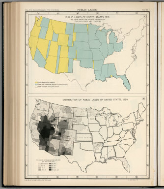
1932 Plate 57. Public Lands of United States, … [Historical Atlas, National Atlas] Plate 57. Public Lands. Public Lands of … |

1932 Plate 58. Public Lands of United States, … [Historical Atlas, National Atlas] Plate 58. Public Lands. Public Lands of … |
1932 Plate 59. Public Lands of United States, … [Historical Atlas, National Atlas] Plate 59. Public Lands. Public Lands of … |

1932 Plate 60. Settlement and Population, 166 … [Historical Atlas, National Atlas] Plate 60. Settlement and Population, 166 … |
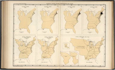
1932 Plate 61. Colonial Towns, States, Territ … [Historical Atlas, National Atlas] Plate 61. Colonial Towns, States, Territ … |

1932 Plate 62. States, Territories and Cities … [Historical Atlas, National Atlas] Plate 62. States, Territories and Cities … |

1932 Plate 63. States, Territories and Cities … [Historical Atlas, National Atlas] Plate 63. States, Territories and Cities … |

1932 Plate 64. States, Territories and Cities … [Historical Atlas, National Atlas] Plate 64. States, Territories and Cities … |