Who What Where WhenREMOVEWHATShow MoreWHERE
|
Title
Brass Trays Isafahan Bazaar, Persia
Description
Sketch for an Illustration from 'Half the World is Isfahan'
Date
1932
Title
Ideas for Sculpture (Transformation Drawing)
Description
null
Date
1932
Title
Prostitute in the Quartier Italie (Fille de Joie, Quartier Italie)
Description
null
Date
1932
Title
L'Oiseau de Bourges
Description
The Printmaker's Society of California 1932
Date
1932
Title
photograph
Description
HCW and sister Martha, H. C. Westermann Sr., and his paternal grandmother
Date
1932
Title
Standing Figure II (Stoíící figura II)
Description
null
Date
1932
Title
Spring Rain at Gokoku-ji Temple
Description
null
Date
1932
Title
Spring Snow, Kiyomizu-temple in Kyoto (Haru no Yuki Kyo no Kiyomizu)
Description
null
Date
1932
Title
A Hovel, rue de Lappe (Un Bouge, rue de Lappe)
Description
null
Date
1932
Title
Engraving for the Circle of Friends of the Bauhaus (Radierung für den "Kreis der Freunde des Bauhauses")
Date
1932
Author
Pacific Gas and Electric Company
Full Title
San Francisco Bay Metropolitan Area (Comprising the Nine Counties Bordering on the Bay). Copyrighted By Pacific Gas And Electric Company December 1932 And Presented To San Francisco Bay Industrial Committee. Compliments of Pacific Gas and Electric Company, San Francisco. (with 2 inset maps of California).
Publisher
Pacific Gas and Electric Company
Author
Kenyon Company
Full Title
Map Of California And Western Nevada. For Latest Census See Back of Map ... Copyrighted, Engraved And Published By The Kenyon Company, Inc., Map Makers, Des Moines, Iowa ... (with 4 inset maps).
Publisher
The Kenyon Company, Inc., Map and Calendar Makers
Author
Kenyon Company
Full Title
Index to California With Latest Official Census, Shipping, And Postal Guide. (with Inset map) Kenyon's United States Federal Highway Map. (on verso) Map Of California And Western Nevada. For Latest Census See Back of Map ... Copyrighted, Engraved And Published By The Kenyon Company, Inc., Map Makers, Des Moines, Iowa ... (with 4 inset maps).
Publisher
The Kenyon Company, Inc., Map and Calendar Makers
Author
Foster and Kleiser
Full Title
The Pacific Coast where the nation will converge in 1932 - An Outdoor Advertising Opportunity. Foster and Kleiser Company.
Publisher
Foster and Kleiser
Author
Rand McNally and Company
Full Title
Rand McNally auto road map Minnesota ... Copyright by Rand McNally & Co. Chicago, Ill. Made In U.S.A.
Publisher
Rand McNally
Author
Rand McNally and Company
Full Title
Rand McNally standard map of Minnesota ... Copyright by Rand McNally & Company, Chicago ...
Publisher
Rand McNally
Author
Rand McNally and Company
Full Title
(Covers to) Rand McNally auto road map Minnesota ... Copyright by Rand McNally & Co. Chicago, Ill. Made In U.S.A.
Publisher
Rand McNally
Author
Rand McNally and Company
Full Title
(Title Page to) Rand McNally auto road map Minnesota ... Copyright 1932 by Rand McNally & Co. Chicago, Ill. Made In U.S.A.
Publisher
Rand McNally
Author
[Paullin, Charles O., Wright, John K.]
Full Title
(Covers to) Atlas of the Historical Geography of the United States. By Charles O. Paullin, Carnegie Institution of Washington. Edited by John K. Wright, Librarian, American Geographical Society of New York. Published Jointly by Carnegie Institution of Washington and the American Geographical Society of New York, 1932.
Publisher
[Carnegie Institution of Washington, American Geographical Society of New York]
Author
[Paullin, Charles O., Wright, John K.]
Full Title
(Title Page) Atlas of the Historical Geography of the United States. By Charles O. Paullin, Carnegie Institution of Washington. Edited by John K. Wright, Librarian, American Geographical Society of New York. Published Jointly by Carnegie Institution of Washington and the American Geographical Society of New York, 1932.
Publisher
[Carnegie Institution of Washington, American Geographical Society of New York]
Author
[Paullin, Charles O., Wright, John K.]
Full Title
(Composite Text of) (Preface, Introduction, Main Text).
Publisher
[Carnegie Institution of Washington, American Geographical Society of New York]
Author
[Paullin, Charles O., Wright, John K.]
Full Title
Plate 1. Natural Environment: Natural Regions, Glaciated Areas, Ocean Currents. Major Geographical Regions. Cultivated Crops. Winds and Sailing Routes - Winter. Winds and Sailing Routes - Summer.
Publisher
[Carnegie Institution of Washington, American Geographical Society of New York]
Author
[Paullin, Charles O., Wright, John K.]
Full Title
Plate 2. Physical Geography and Vegetation. Relief; Soil Regions. Physical Divisions. Vegetation Regions.
Publisher
[Carnegie Institution of Washington, American Geographical Society of New York]
Author
[Paullin, Charles O., Wright, John K.]
Full Title
Plate 3. Forests; Growing Season. Area of Virgin Forest 1620. Area of Virgin Forest 1850. Area of Virgin Forest 1926. National Forest 1930. Average Length of Growing Season.
Publisher
[Carnegie Institution of Washington, American Geographical Society of New York]
Author
[Paullin, Charles O., Wright, John K.]
Full Title
Plate 4. Climate. Snow Cover. Droughts. Relative Humidity. Cloudiness. Pressure.
Publisher
[Carnegie Institution of Washington, American Geographical Society of New York]
Author
[Paullin, Charles O., Wright, John K.]
Full Title
Plate 5. Climate. Temperature. Rainfall.
Publisher
[Carnegie Institution of Washington, American Geographical Society of New York]
Author
[Paullin, Charles O., Wright, John K.]
Full Title
Plate 6. Mineral Resources. Coal Fields, Distribution and Production of Iron Ore.
Publisher
[Carnegie Institution of Washington, American Geographical Society of New York]
Author
[Paullin, Charles O., Wright, John K.]
Full Title
Plate 7. Mineral Resources. Oil and Gas Fields. Gold, Silver, and Copper Districts.
Publisher
[Carnegie Institution of Washington, American Geographical Society of New York]
Author
[Paullin, Charles O., Wright, John K.]
Full Title
Plate 45. Lands. Grants of Western Lands by Georgia to Land Companies, 1789. 1875. Military Reserves, 1778 - 1816.
Publisher
[Carnegie Institution of Washington, American Geographical Society of New York]
Author
[Paullin, Charles O., Wright, John K.]
Full Title
Plate 46. Lands. British Possessions after the Quebec Act, 1774. Proposed States According to Ordinance of 1784. Territorial Acquisitions 1783-1853.
Publisher
[Carnegie Institution of Washington, American Geographical Society of New York]
Author
[Paullin, Charles O., Wright, John K.]
Full Title
Plate 47. Lands. Indian Cessions 1750-1890. Claims and Cessions of Western Lands, 1776-1803 Connecticut and South Carolina. Claims and Cessions of Western Lands, 1776-1802, New York. Claims and Cessions of Western Lands, 1776-1802, Virginia and Georgia. Claims and Cessions of Western Lands, 1776-1802, Massachusetts and North Carolina.
Publisher
[Carnegie Institution of Washington, American Geographical Society of New York]
Author
[Paullin, Charles O., Wright, John K.]
Full Title
Plate 54. Lands. A Modern City, Springfield, Illinois, 1915 (Facsimile).
Publisher
[Carnegie Institution of Washington, American Geographical Society of New York]
Author
[Paullin, Charles O., Wright, John K.]
Full Title
Plate 56. Lands. A Western Town: Carroll, Nebraska, 1918. A Western Township Pilot Knob, Harper County, Kansas, 1919. Specimen Private Land Claims, 1835. Federal Land Grants for the Construction of Railroads and Wagon Roads, 1823-1871. Oil Land Withdrawals in California, 1915 (Facsimiles).
Publisher
[Carnegie Institution of Washington, American Geographical Society of New York]
Author
[Paullin, Charles O., Wright, John K.]
Full Title
Plate 57. Public Lands. Public Lands of United States, 1790. Public Lands of United States, 1810.
Publisher
[Carnegie Institution of Washington, American Geographical Society of New York]
Author
[Paullin, Charles O., Wright, John K.]
Full Title
Plate 58. Public Lands. Public Lands of United States, 1830. Public Lands of United States, 1850. Public Lands of United States, 1870. Public Lands of United States, 1890.
Publisher
[Carnegie Institution of Washington, American Geographical Society of New York]
Author
[Paullin, Charles O., Wright, John K.]
Full Title
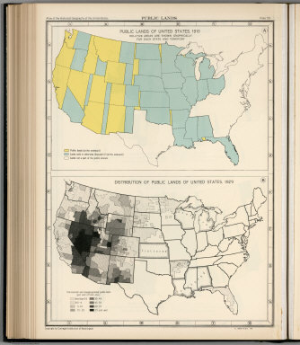
Plate 59. Public Lands. Public Lands of United States, 1910. Distribution of Public Lands of United States, 1929.
Publisher
[Carnegie Institution of Washington, American Geographical Society of New York]
Author
[Paullin, Charles O., Wright, John K.]
Full Title
Plate 60. Settlement and Population, 1660-1790. Settled Areas and Population, 1660. Settled Areas and Population, 1770. Settled Areas, 1760, and Population, 1750. Settled Areas and Population, 1775. Settled Areas and Population, 1790.
Publisher
[Carnegie Institution of Washington, American Geographical Society of New York]
Author
[Paullin, Charles O., Wright, John K.]
Full Title
Plate 61. Colonial Towns, States, Territories, and Cities. Colonial Towns, 1650. Colonial Towns, 1700. Colonial Towns, 1750. Colonial Towns, 1775. States, Territories and Cities, 1790. States, Territories and Cities, 1800. States, Territories and Cities, 1810.
Publisher
[Carnegie Institution of Washington, American Geographical Society of New York]
Author
[Paullin, Charles O., Wright, John K.]
Full Title
Plate 62. States, Territories and Cities. States, Territories and Cities, 1820. States, Territories and Cities, 1830.
Publisher
[Carnegie Institution of Washington, American Geographical Society of New York]
Author
[Paullin, Charles O., Wright, John K.]
Full Title
Plate 63. States, Territories and Cities. States, Territories and Cities, 1840. States, Territories and Cities, 1850.
Publisher
[Carnegie Institution of Washington, American Geographical Society of New York]
Author
[Paullin, Charles O., Wright, John K.]
Full Title
Plate 64. States, Territories and Cities. States, Territories and Cities, 1860. States, Territories and Cities, 1870. States and Territories (Additional Maps 1845-1868). States, Territories and Cities, 1880.
Publisher
[Carnegie Institution of Washington, American Geographical Society of New York]
|