Browse All

1940 #9, New York, 1940 |

1940 Approaching Storm |

1940 Charley's Eye |

1940 Election Year Times Square, NYC |

1940 Festa |

1940 Harbinger |

1940 I.D. 1940 |

1940 Portrait of Albert M. Bender |

1940 Nude with Bracelet (Nu au Bracelet) |

1940 photograph |

1940 Mexico City: Diego Rivera Mural in Natio … |

1940 New York |

1940 Woman with Hose |

1940 Tire and Column [West Palm Beach, Florid … |

1940 Untitled (Standing Nudes--2 photos, 1 cu … |

1940 Untitled [Clown's mask] |

1940 Unemployed Men Times Square, NYC |
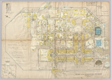
1940 Golden Gate International Exposition. Separate Map Golden Gate International Exposition (19 … |

1940 Covers: World Pocket Map (Covers to) World at a Glance. Bituminou … |

1940 Covers: World Pocket Map World at a Glance. Bituminous Casualty C … |

1940 Covers: World Pocket Map World at a Glance. Bituminous Casualty C … |

1940 Washington, Oregon, Idaho. Pocket Map Washington - Oregon and Idaho. Copyright … |

1940 Verso: Washington, Oregon, Idaho. Pocket Map (Verso of) Washington - Oregon and Idaho … |

1940 Cover: Washington, Oregon, Idaho. Pocket Map (Covers to) Washington - Oregon and Idah … |

1940 Western Hemisphere. Wall Map Western Hemisphere. |

1940 Iowa -- Physical-Political Wall Map Iowa, Physical and Political. |

1940 Covers: State Farm Road Atlas: United St … National Atlas (Covers to) State Farm Road Atlas: Unite … |

1940 Title Page: State Farm Road Atlas: Unite … National Atlas (Title Page to) State Farm Road Atlas: U … |

1940 Contents: State Farm Road Atlas: United … National Atlas (Contents to) State Farm Road Atlas: Uni … |

1940 Advertisement: State Farm Road Atlas: Un … National Atlas (Advertisement to) State Farm Road Atlas … |

1940 Text Page: National Parks Touring Inform … National Atlas Text Page to) National Parks Touring Inf … |

1940 Text Page: (Coninues) National Parks Tou … National Atlas Text Page to) National Parks Touring Inf … |

1940 Text Page: (Coninues) National Parks Tou … National Atlas Text Page to) National Parks Touring Inf … |

1940 Map of South and Central America National Atlas Map of South and Central America. Showin … |

1940 United States Railroad map National Atlas Rand McNally handy Railroad map United S … |
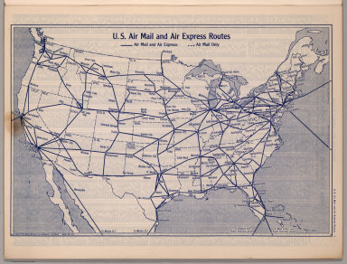
1940 U.S. Air Mail and Air Express Routes National Atlas U.S. Air Mail and Air Express Routes. Co … |

1940 Index: Index to Counties, Cities and Tow … National Atlas (Index to) Index to Counties, Cities, an … |

1940 Index:(Continues) Index to Counties, Cit … National Atlas (Index to) Index to Counties, Cities, an … |

1940 Index:(Continues) Index to Counties, Cit … National Atlas (Index to) Index to Counties, Cities, an … |

1940 Index:(Continues) Index to Counties, Cit … National Atlas (Index to) Index to Counties, Cities, an … |

1940 Index:(Continues) Index to Counties, Cit … National Atlas (Index to) Index to Counties, Cities, an … |

1940 Index:(Continues) Index to Counties, Cit … National Atlas (Index to) Index to Counties, Cities, an … |

1940 Index:(Continues) Index to Canadian Citi … National Atlas (Index to) Index to Counties, Cities, an … |

1940 United States Road Map National Atlas Rand McNally Road map, United States. Co … |

1940 Road map of Alabama National Atlas Rand McNally Road map, Alabama. Copyrigh … |

1940 Road map of Arizona, New Mexico National Atlas Rand McNally Road map, Arizona, New Mexi … |

1940 Road map of Arkansas, Louisiana, Mississ … National Atlas Rand McNally Road map, Arkansas, Louisia … |

1940 Road map of California National Atlas Rand McNally Road map, California. Copyr … |

1940 Road map of Colorado National Atlas Rand McNally Road map, Colorado. Copyrig … |

1940 Road map of Connecticut, Massachusetts, … National Atlas Rand McNally Road map, Connecticut, Mass … |