Who What Where WhenREMOVEWHAT
|
Author
Covarrubias, Miguel (1904-1957)
Full Title
Plate III. Art Forms of the Pacific Area. Pageant of the Pacific.
Publisher
Pacific House
Author
Covarrubias, Miguel (1904-1957)
Full Title
Plate IV. Economy of the Pacific. Pageant of the Pacific.
Publisher
Pacific House
Author
Covarrubias, Miguel (1904-1957)
Full Title
Plate V. Native Dwellings of the Pacific Area. Pageant of the Pacific.
Publisher
Pacific House
Author
Covarrubias, Miguel (1904-1957)
Full Title
Plate VI. Native Means of Transportation in the Pacific Area. Pageant of the Pacific.
Publisher
Pacific House
Author
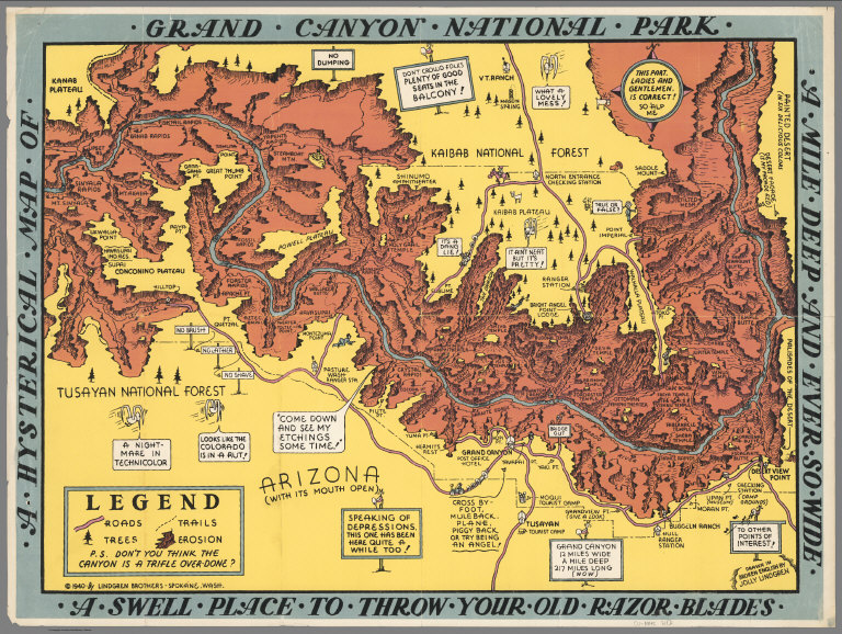
Lindgren Brothers
Full Title
A Hysterical Map of the Grand Canyon National Park.
Publisher
Lindgren Brothers
Author
[Lindgren Brothers, Lindgren, Jolly]
Full Title
A Hysterical Map of the Grand Coulee Dam.
Publisher
Lindgren Brothers
Author
[International Tea Market Expansion Board Limited, Gill, Leslie MacDonald, 1884-1947]
Full Title
Tea. Revives. The. World. MacDonald Gill 1940. Issued by the International Tea Market Expansion Board Limited. Printed in England. S.H.B. Ltd. Regd. No. 4950.
Publisher
International Tea Market Expansion Board Limited
Author
Colonial Craftsmen
Full Title
Decorative Map of Cape Cod. The Reaches of Cape Cod, Nantucket, and Martha's Vineyard, Massachusetts. Copyrighted 1940 ... Colonial Craftsmen, P.O.912, Attleboro, Massachusetts.
Publisher
Colonial Craftsmen
Author
Global Map Company
Full Title
(Covers to) The Global Map. Pat. No. D136173, Other Patents Pending. The Global Map Co. Minneapolis, Minn. Copyright By The H.M. Gousha Company, Chicago, Ill. Lithographed In U.S.A.
Publisher
The Global Map Company
Author
Global Map Company
Full Title
The Global Map. Pat. No. D136173, Other Patents Pending. The Global Map Co. Minneapolis, Minn.
Publisher
The Global Map Company
Author
Global Map Company
Full Title
(Verso of) The Global Map. Pat. No. D136173, Other Patents Pending. The Global Map Co. Minneapolis, Minn.
Publisher
The Global Map Company
Author
California Department of Public Works, Division of Highways
Full Title
Road Map of the State of California, July, 1940.
Publisher
California Department of Transportation (CALTRANS)
Author
California Department of Public Works, Division of Highways
Full Title
(Verso) Road Map of the State of California, July, 1940.
Publisher
California Department of Transportation (CALTRANS)
Author
Great Britain. Ordnance Survey
Full Title
(Covers to) Ordnance Survey of Great Britain. New Popular One-Inch Map with National Grid, England and Wales. Volume 1 (of 4).
Publisher
Ordnance Survey of Great Britain
Author
Great Britain. Ordnance Survey
Full Title
Sheet 87. Isle of Man. (also known as Sheet 17).
Publisher
Ordnance Survey of Great Britain
Author
Great Britain. Ordnance Survey
Full Title
(Covers to) Ordnance Survey of Great Britain. New Popular One-Inch Map with National Grid, England and Wales. Volume 2 (of 4).
Publisher
Ordnance Survey of Great Britain
Author
Great Britain. Ordnance Survey
Full Title
(Covers to) Ordnance Survey of Great Britain. New Popular One-Inch Map with National Grid, England and Wales. Volume 3 (of 4).
Publisher
Ordnance Survey of Great Britain
Author
Great Britain. Ordnance Survey
Full Title
Sheet 157. Swindon.
Publisher
Ordnance Survey of Great Britain
Author
Great Britain. Ordnance Survey
Full Title
Sheet 158. Oxford and Newbury.
Publisher
Ordnance Survey of Great Britain
Author
Great Britain. Ordnance Survey
Full Title
Sheet 161. London, N.E.
Publisher
Ordnance Survey of Great Britain
Author
Great Britain. Ordnance Survey
Full Title
(Covers to) Ordnance Survey of Great Britain. New Popular One-Inch Map with National Grid, England and Wales. Volume 4 (of 4).
Publisher
Ordnance Survey of Great Britain
Author
Great Britain. Ordnance Survey
Full Title
Sheet 167. Salisbury.
Publisher
Ordnance Survey of Great Britain
Author
Great Britain. Ordnance Survey
Full Title
Sheet 169. Aldershot.
Publisher
Ordnance Survey of Great Britain
Author
Great Britain. Ordnance Survey
Full Title
Sheet 171. London, S.E.
Publisher
Ordnance Survey of Great Britain
Author
Great Britain. Ordnance Survey
Full Title
Sheet 172. Chatham and Maidstone.
Publisher
Ordnance Survey of Great Britain
Author
Great Britain. Ordnance Survey
Full Title
Sheet 179. Bournemouth.
Publisher
Ordnance Survey of Great Britain
Author
Great Britain. Ordnance Survey
Full Title
Sheet 182. Brighton and Worthing.
Publisher
Ordnance Survey of Great Britain
Author
Great Britain. Ordnance Survey
Full Title
Sheet 183. Eastbourne.
Publisher
Ordnance Survey of Great Britain
Author
Great Britain. Ordnance Survey
Full Title
Sheet 184. Hastings.
Publisher
Ordnance Survey of Great Britain
Author
Chase, Ernest Dudley, 1878-1966
Full Title
The pictorial map : United States Stamps. Designed, drawn and published by Ernest Dudley Chase. Winchester, Mass.; Research directors Charles Peck Kerr and Rupert Frank Jones. The post : Artists: Famous American Commemorative Series -- 1940.
Publisher
Ernest Dudley Chase.
|