Browse All

1946 The Black Grouper (Shedd Aquarium #3) |

1946 Brother and Sister, Spanish Refugees, So … |

1946 Dining Chair |

1946 document |

1946 Carl Erickson Drawing Gertrude Stein and … |

1946 Collage Eight |

1946 Tête de Femme (Pour Versailles) |

1946 Iwai Bridge, Sakuyama, Yashü [Iwai Bridg … |

1946 Lounge Chair |

1946 Low Landscape |

1946 Ringling Bros. Barnum & Bailey, Chicago, … |

1946 Rooftops, New York City |

1946 Group of Young Boys |

1946 Kaleidescopic Bridge (Michigan Avenue) |

1946 Third Ave., NYC |

1946 Strength, Balance, Beauty - Wayne & West … |

1946 Untitled [Photogram] |

1946 Untitled |

1946 Denture Shop, Rawalpindi, India |

1946 Covers: Recreational map of New Mexico l … Separate Map (Covers to) Recreational map of New Mexi … |

1946 Recreational map of New Mexico : the lan … Separate Map Recreational map of New Mexico : the lan … |

1946 Text Page: Recreational map of New Mexic … Separate Map (Text Page to) Recreational map of New M … |

1946 Covers: Preliminary Report on Harbors, H … [Regional Atlas, Aerial Photographs] (Covers to) Preliminary Report on Harbor … |

1946 Title Page: Preliminary Report on Harbor … [Regional Atlas, Aerial Photographs] (Title Page) Preliminary Report on Harbo … |

1946 Text: Photographic Credits. [Aerial Photographs, Regional Atlas] (Text Page) The excellent photographs we … |

1946 Text: Introductory Page. [Regional Atlas, Aerial Photographs] (Text Page) Introductory Page. |

1946 Southeast Farralon Island. [Aerial Photographs, Regional Atlas] SE Farralon. |

1946 Golden Gate Bridge, San Francisco, Calif … [Aerial Photographs, Regional Atlas] Golden Gate SF |

1946 Bolinas Bay, California. [Regional Atlas, Aerial Photographs] Bolinas Bay. |

1946 Bolinas Bay. Duxbury Reef. [Regional Atlas, Aerial Photographs] Bolinas Bay. Duxbury Reef. |

1946 Drakes Bay and Pt. Reyes. [Regional Atlas, Aerial Photographs] Drakes Bay and Pt. Reyes. |

1946 Bodega Bay. [Aerial Photographs, Regional Atlas] Bodega Bay. |

1946 Bodega Bay. [Aerial Photographs, Regional Atlas] Bodega Bay. |

1946 Mendocino Bay. [Aerial Photographs, Regional Atlas] Mendocino Bay. |

1946 Noya Harbor. Fort Bragg. [Aerial Photographs, Regional Atlas] Noya Harbor. Fort Bragg. |

1946 Noyo River. [Aerial Photographs, Regional Atlas] Noyo River. |

1946 Cape Mendocino. Blunt's Reef. [Aerial Photographs, Regional Atlas] Cape Mendocino. Blunt's Reef. |

1946 Eel River Outlet. [Aerial Photographs, Regional Atlas] Eel River Outlet. |

1946 Humboldt Bay Entrance. [Aerial Photographs, Regional Atlas] Humboldt Bay Entrance. |

1946 Humboldt Bay Entrance. Eureka. [Aerial Photographs, Regional Atlas] Humboldt Bay Entrance. Eureka. |

1946 Humboldt Bay Entrance. [Aerial Photographs, Regional Atlas] Humboldt Bay Entrance. |

1946 Trinidad Head. [Aerial Photographs, Regional Atlas] Trinidad Head. |

1946 Crescent City. [Aerial Photographs, Regional Atlas] Crescent City. |

1946 Crescent City. [Aerial Photographs, Regional Atlas] Crescent City. |

1946 Rogue River Outlet. [Aerial Photographs, Regional Atlas] Rogue River outlet. |

1946 Rogue River Outlet. [Aerial Photographs, Regional Atlas] Rogue River. |

1946 Port Orford. [Aerial Photographs, Regional Atlas] Port Orford. |
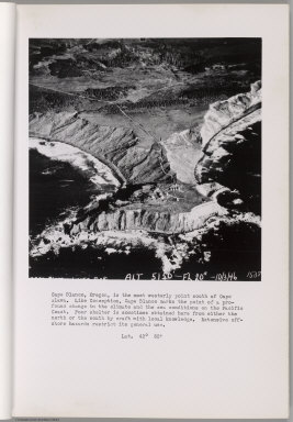
1946 Cape Blanco. [Aerial Photographs, Regional Atlas] Cape Blanco. |

1946 Cape Blanco. [Aerial Photographs, Regional Atlas] Cape Blanco. |

1946 Bandon. Coquille River. [Aerial Photographs, Regional Atlas] Bandon. Coquille River. |