Who What Where WhenREMOVEWHERE
WHOShow More |
Author
Colton, G.W.
Full Title
Northern Regions. Published by J.H. Colton And Co. 172 William St. New York. Entered ... 1855 by J.H. Colton & Co. ... New York. No. XII.
Publisher
J.H. Colton
Author
Jefferys, Thomas
Full Title
A Chart of North and South America, including the Atlantic and Pacific Oceans, with the nearest Coasts of Europe, Africa, and Asia. Chart containing part of the Icy Sea with the adjacent Coast of Asia and America. Chart comprizing Greenland with the Countries and Islands about Baffins Bay and part of Hudsons Bay. Publish'd ... 10 June 1775, by Robt. Sayer & J. Bennett ... Fleet Street. No. II.
Publisher
Sayer and Bennett
Author
Jefferys, Thomas
Full Title
The Russian Discoveries, from the Map Published by the Imperial Academy of St. Petersburg. London, Printed for Robt. Sayer, Map & Printseller, No. 53 in Fleet Street. Published as the Act directs March 2d, 1775.
Publisher
Sayer and Bennett
Author
Meyer, Joseph, 1796-1856
Full Title
Neueste Karte vom Nord Pol. Hildburghausen, Verlag vom Bibliogr. Institut, (1860)
Publisher
Bibliographischen Instituts
Author
Instituto Geographico di Agostini
Full Title
Regioni Polari Artiche. (insets) Spitzberg; Stretto di Bering; Ie. Diomede; I.D. Orsi; Arc. Franc. Giuseppe; Isfjord (Spitzberg). Regioni Polari Antartiche. (insets) Sandwich Austr.; Orcadi Austr.; Ie. Pr. Edward; Ie. Crozet; Ie. Heard; Kergurlen; Georgia D. Sud; Ross Ice Shelf; Edsel Ford Ranges.
Publisher
Instituto Geographico di Agostini
Author
Colton, G.W.
Full Title
Northern Regions. Southern Regions. Published by G. W & C. B. Colton & Co., No. 182 William St. New York.
Publisher
G. W & C. B. Colton & Co.
Author
Colton, G.W.
Full Title
Northern Regions. Southern Regions. Published by G. W & C. B. Colton & Co., No. 172 William St. New York.
Publisher
G. W & C. B. Colton & Co.
Author
Colton, G.W.
Full Title
Northern Regions. Southern Regions. Published by G.W. & C.B. Colton & Co., No. 172 William St. New York.
Publisher
G.W. & C.B. Colton
Author
Harrison, Richard Edes
Full Title
Arctic Arena. Orthographic Projection. (to accompany) Look At The World: The Fortune Atlas For world Strategy. By Richard Edes Harrison. Text by Editor of Fortune. New York: Alfred A. Knopf 1944. (on verso) Copyright 1944 by Time Incorporated.
Publisher
A. A. Knopf
Author
Harrison, Richard Edes
Full Title
Eight Views Of The World. (by) Richard Edes Harrison 1943. Exhibiting the location of The U.S. Islands. Europe. Africa. Argentina. Australia. Alaska. And Asia. (to accompany) Look At The World: The Fortune Atlas For world Strategy. By Richard Edes Harrison. Text by Editor of Fortune. New York: Alfred A. Knopf 1944. (on verso) Copyright 1944 by Time Incorporated.
Publisher
A. A. Knopf
Author
Harrison, Richard Edes
Full Title
Great Circle Airways. Natural scale at point of tangency 1:81,000,000. North Polar Gnomonic Projection. (inset) North Polar Azmuthal Equidistant Projection. (inset) South Polar Genomonic Chart. (to accompany) Look At The World: The Fortune Atlas For world Strategy. By Richard Edes Harrison. Text by Editor of Fortune. New York: Alfred A. Knopf 1944. (on verso) Copyright 1944 by Time Incorporated.
Publisher
A. A. Knopf
Author
Bartholomew, John
Full Title
(Index to) Arctic Ocean, Greenland. Polar Azimuthal Equidistant Projection. 1:12,500,000.
Publisher
[Houghton Mifflin Co., John Bartholomew & Son LTD.]
Author
Bartholomew, John
Full Title
Arctic Ocean, Greenland. The Geographical Institute Edinburgh. Edited by John Bartholomew, M.C., LL.D. (Copyright), John Bartholomew & Son, LTD. (inset maps) Greenland Coastal Settlements, 1:5,000,000.
Publisher
[Houghton Mifflin Co., John Bartholomew & Son LTD.]
Author
Bartholomew, John
Full Title
(Index to) Canada and Arctic America. Chamberlin Trimetric Projection, (By courtesy of the National Geographic Society, Washington, D.C.), Standard Parallels 33 (degrees) and 45 (degrees) N. 1:12,500,000.
Publisher
[Houghton Mifflin Co., John Bartholomew & Son LTD.]
Author
Bartholomew, John
Full Title
Canada and Arctic America. The Geographical Institute Edinburgh. Edited by John Bartholomew, M.C. LL. D. Copyright - John Bartholomew & Son, LTD. (inset map) Aleutian Islands, On the same scale.
Publisher
[Houghton Mifflin Co., John Bartholomew & Son LTD.]
Author
[Thomson, John, Wyld, James, 1790-1836]
Full Title
Discoveries Capts. Ross, Parry & Franklin in the Arctic Regions. in 1818, 1819, 1820, 1821 & 1822. (Published by John Thomson & Co. Edinburgh.) (to accompany) A General Atlas, Containing Maps illustrating some important periods in Ancient History; and distinct Maps of the several Empires, Kingdoms and States In The World, From Original Drawings according to the latest Treaties by J. Wyld and Engraved by N.R. Hewitt. Edinburgh, Printed for John Thomson & Co for Baldwin, Cradock & Joy, London & John Cumming, Dublin.
Publisher
John Thomson
Author
[Bayer, Herbert, Container Corporation of America]
Full Title
North Polar Regions. South Polar Regions.
Publisher
Container Corporation of America
Author
Arrowsmith, Aaron
Full Title
Map of the Countries Round the North Pole By A. Arrowsmith. London. Published 1. Feb. 1818, by A. Arrowsmith, Hydrographer to H.R.H. the Prince of Wales, 10 Soho Square. Engraved by Sidney Hall.
Publisher
A. Arrowsmith
Author
Marzolla, Benedetto
Full Title
Carta generale del Polo Artico. Benedetto Marzolla, Napoli 1844, esegui col pennello su pietra, Real Litografia Militare.
Publisher
B. Marzolla
Author
Ruhle von Lilienstern, August
Full Title
Laender um den Nordpol. Berlin 1824. von R.v.L. Die Berge grav. von H. Bock.
Publisher
C.G. Luderitz
Author
[Edward Stanford Ltd., Stanford, Edward]
Full Title
Map of the countries round the North Pole. London atlas series. Stanford's Geographical Estabt., London. London : Edward Stanford, 26 & 27 Cockspur St., Charing Cross, S.W. (1901)
Publisher
Edward Stanford
Full Title
The Polar Regions. George Philip & Son, Ltd. The London Geographical Institute. (1922)
Publisher
[C.S. Hammond & Company. London: George Philip & Son, Ltd. The London Geographical Institute, Philip, Son & Nephew, Ltd.]
Author
Reichard, C. G.
Full Title
Atlas des ganzen Erdkreises in der Central-Projection entworfen von C.G. Reichard. Fuinfte Tafel. 1803.
Publisher
Landes Industrie Comptoir
Author
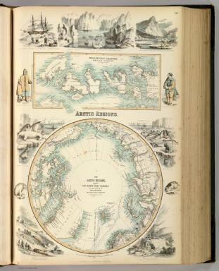
Fullarton, A. & Co.
Full Title
Arctic Regions. The Arctic Regions, showing the North-West Passage as determined by Cap. R. McClure and other Arctic Voyagers. Compiled by J. Hugh Johnson, F.R.G.S. (with) Wellington Channel, Melville Island &c. from Admiralty Chart. III. Engraved by A. Fullarton & Co. A. Fullarton & Co. London and Edinburgh.
Publisher
A. Fullarton & Co.
Author
Brue, Adrien Hubert, 1786-1832
Full Title
Carte generale de la Russie d'Asie et des regions polaires boreales, par A.H. Brue, Geographe de S.A.R. Monsieur. A Paris, Chez l'Auteur, rue des Macons-Sorbonne, no. 9, et chez les principaux marchands de geographie. Aout 1821.
Publisher
A. Brue
Author
[Wenschow, Karl, Denoyer-Geppert Company]
Full Title
Nordpolargebiet Sudpolargebiet, Wenschow-Reliefkart.
Publisher
Karl Wenschow
Author
Carlberg, Berthold
Full Title
Nordpolargebiet.
Publisher
Justus Perthes
Author
W. & A.K. Johnston Limited
Full Title
North Polar Chart.
Publisher
W. & A.K. Johnston Limited
Author
[Klett-Perthes, Haack-Painke]
Full Title
Nordamerika.
Publisher
Justus Perthes Verlag Gotha GmbH
Author
Bauman, William
Full Title
Map Of The North Polar Region. The Graphic Co. 39 & 41 Park Place, N.Y. Wm. Bauman del. (inset profile) Wrangell Land ... As seen from Bark Nile of New London, Capt. Th. Long. Aug. 14th, 15th & 16th 1867, 15 to 18 miles distant. From U.S. Hydrographic Office Chart No. 68. U.S.N. Pac. Surv'g. Expedition in 1855. Comdr. John Rodgers U.S.N.
Publisher
Graphic Company
Author
Koversky, Eduard Avraamovich
Full Title
Karta Aziatskoi Rossii i smezhnykhi s neiu vladenii : S ukazanem puti sldovaniia Gosudaria Imperatora v 1890-91 gg. v bytnost Ego velichestva nasldnikom tsesarevichem i Velikoi Sibirskoi zhelznoi dorogi. (cover title in French) Carte de la Russie d'Asie et des pays limitrophes. (with inset and 11 views).
Publisher
No publisher
Author
Thomson, John
Full Title
A chart of the discoveries of Captains Ross, Parry & Franklin in the Arctic Regions in the years 1818, 1819, 1820, 1821 & 1822. (with) Capt. Franklin's journey from Coppermine River to the head of Bathurst Inlet & return by Hood's River. J. Aspin delt. Hewitt sc., Buckingham Place. (Drawn & engraved for Thomson's New general atlas) (1822?)
Publisher
[Baldwin, Cradock, and Joy, John Cumming, John Thomson]
Author
[Bory de Saint-Vincent, M. (Jean Baptiste GeneviFve Marcellin), 1778-1846, Desmarest, Nicolas, 1725-1815, Vincent]
Full Title
Carte des glaces, circompolaires boreales. Grave par Berthe. (A Paris, Chez Mme. veuve Agasse, Imprimeur-Libraire, rue des Poitevins, no. 6. M.DCCCXXVII)
Publisher
Veuve Agasse
Author
[Covens et Mortier, Lisle, Guillaume de, 1675-1726]
Full Title
L'Hemisphere Meridional pour voir plus distinctement les Terres Australes. Par Guillaume de l'Isle de l'Academie Rle. des Sciences. A Amsterdam, Chez Jean Covens et Corneille Mortier, Geographies. (with) Plan et vue des terres du Cap de la Circoncision ... Plan en Gezigt van de Landen van de Caap der Besnydenis ... (1742?)
Publisher
Covens & Mortier
Author
Touring club italiano
Full Title
Terre polari. (Propr. Artistico-letteraria del T.C.I. Ufficio cartografico del T.C.I. 1929)
Publisher
Touring club italiano
Author
[Bartholomew, J. G. (John George), 1860-1920, John Bartholomew and Son]
Full Title
North Polar regions. The Edinburgh Geographical Institute, John Bartholomew & Son, Ltd. "The Times" atlas. (London: The Times, 1922)
Publisher
The Times
Full Title
North Polar Regions. (with) Novaya Zemlya. (with) Spitzbergen and Bear Island. (with) Coast of east Greenland between 720 and 770 north latitude. (with) South-west Greenland. (Published at the office of "The Times," London, 1895)
Publisher
The Times
Full Title
Karte der Nordpolarregion. (with) Nowaja Semlja. (with) Spitzbergen und die Baren Insel. (with) Sud-west Gronland. (with) Kuste von Ost-Gronland zwischen 72 u. 770 nordl. Br. Nach den Aufnahmen der zweiten Deutschen Nord-Pol Expedit. 1869-1870. (Richard Andree. Herausgegeben von der Geographischen Anstalt von Velhagen & Klasing in Leipzig. 1881)
Publisher
Velhagen & Klasing
Full Title
Karte der Sudpolarregion. Polynesische Inselgruppen: Viti-Fidschi, Inseln. Hawaii-Sandwich, Inseln. Samoa-Schiffer, Inseln. (with) Victoria-Land. (Richard Andree. Herausgegeben von der Geographischen Anstalt von Velhagen & Klasing in Leipzig. 1881)
Publisher
Velhagen & Klasing
Author
Hayes, Isaac Israel
Full Title
Baffin Bay, illustrating an Arctic boat journey in 1854. I.I. Hayes. (1855?)
Publisher
Manuscript
Author
King, G. B.
Full Title
Chart of the Polar Seas. Engraved for Harpers Family Library, by (G.B.?) King. (185-?)
Publisher
Harper & Brothers?
Author
Stieler, Adolf
Full Title
No. VIII. Stieler's Hand-Atlas (No. 41b). Polar-Karte ....
Publisher
Justus Perthes
Author
Carey, Mathew
Full Title
A Map of the Countries situate about the North Pole as far as the 50th Degree of North Latitude. W. Barker sculp. Engraved for Carey's Edition of Guthrie's Geography improved.
Publisher
M. Carey
Author
Stieler, Adolf
Full Title
No. VIII. Stieler's Hand-Atlas (No. 41b). Polar-Karte ....
Publisher
Justus Perthes
Author
Carey, Mathew
Full Title
A Map of the Countries situate about the North Pole as far as the 50th Degree of North Latitude. W. Barker sculp. Engraved for Carey's Edition of Guthrie's Geography improved.
Publisher
Mathew Carey
Author
[Andree, Richard, Scobel, Albert]
Full Title
Nordpolargebiete. Okt. 1905. (insets:nebenkarten) Nowaja Semlja. Sudwest-Gronland ; Spitzbergen und die Bareninsel ; Kuste von Ost Gronland.
Publisher
Velhagen & Klasing
Author
Carey, Mathew
Full Title
A Map of the Countries situate about the North Pole as far as the 50th Degree of North Latitude. W. Barker sculp. Engraved for Carey's Edition of Guthrie's Geography improved.
Publisher
Mathew Carey
Author
Stieler, Adolf
Full Title
Polar-Karte enthaltend: die Lander u. Meere vom Nord-Pol bis 50 (degrees) N. Br. u. weiter, sowie Ubersicht des Russischen Reichs. Gez. v. Ad. Stieler 1832. Nachtrage v. Hrm. Bghs v 1853-1874. Gestochen v. Carl Poppey. Gotha: Justus Perthes 1875.
Publisher
Justus Perthes
Author
Debenham, Frank
Full Title
North Pole lands. The Arctic Ocean encircled by North America and Eurasia, the largest land mass in the world. (copyright) G.P. Ltd. (inset) Map of Iceland, showing part of the remains of the last Ice Age.
Publisher
Simon and Schuster
|