|
Author
Berghaus, Heinrich
Full Title
Asia-Europa; in Beziehung auf das Fliessende, und seine Vertheilung in Stromgebiete. 2te Abtheilung: Hydrographie, No. 7. Potsdam, gez. u. gest. in der geograph. Kunstschule. Gotha bei J. Perthes. 1841.
Publisher
Justus Perthes
Author
Berghaus, Heinrich
Full Title
Bergketten In Asien Und Europa. 3te Abtheilung: Geologie, No. 2. Potsdam, gez. u. gest. in der geogr. Kunstschule. Gotha, bei Justus Perthes, 1842.
Publisher
Justus Perthes
Author
Berghaus, Heinrich
Full Title
Verbreitung der vorzuglicheren Saugethiere der Alten Welt. 6te. Abtheilung: Geographie der Thiere No. 5. Gez. in der geogr. Kunstschule zu Potsdam. Gestochen von Joh. Carl Ausfeld. Gotha, bei J. Perthes, 1845.
Publisher
Justus Perthes
Author
Berghaus, Heinrich
Full Title
Die Volker Asien's Und Europa's. 8te Abtheilung: Ethnographie No 1. Gotha, bei Justus Perthes. 1847.
Publisher
Justus Perthes
Author
Ruhle von Lilienstern, August
Full Title
Graenz und Oerter-Karte von Europa. Berlin 1825 von R.v.L.
Publisher
C.G. Luderitz
Author
[Edward Stanford Ltd., Stanford, Edward]
Full Title
Sketch of the acquisitions of Russia in Europe and Central Asia since the accession of Peter 1st to the throne. London atlas series. Stanford's Geographical Establishment. London : Edward Stanford, 26 & 27, Cockspur St., Charing Cross, S.W. (1901)
Publisher
Edward Stanford
Author
[Homann, Johann Baptist, 1663-1724, Hubner, Johann, 1688-1731]
Full Title
(Charte von Europa. Charte von Asia. Charte von Africa. Charte von America. Johanne Baptista Homanno, Norimbergae, 1719)
Publisher
Johann Baptist Homann.
Author
Berghaus, Hermann
Full Title
Asien und Europa. (with) Japan von Dr. Edm. Naumann, Korea von Dr. C. Gottsche. (with) Indisches Salz-Gebirge. (with) Lavastrom des Asama Jama von J(ahr) 1783. (with) Java nach F. Junghulm. Entw. v. Herm. Berghaus 1887, Ausg. 1889. Gest. v. K. Poppey u. P. Grabhein. Gotha: Justus Perthes (1892)
Publisher
Justus Perthes
Author
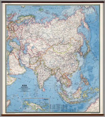
[Rogers, Richard, National Geographic Society]
Full Title
Asia.
Publisher
National Geographic Society
Author
Klett-Perthes
Full Title
Asia. Political
Publisher
Justus Perthes Verlag Gotha GmbH
Author
Klett-Perthes
Full Title
Asia. Physical.
Publisher
Justus Perthes Verlag Gotha GmbH
Author
Haack-Painke
Full Title
Asia.
Publisher
Justus Perthes Verlag Gotha GmbH
Author
Haack, Hermann
Full Title
Asien.
Publisher
Justus Perthes
Author
Mellish, John
Full Title
Terra Veteribus Nota. Engraved for Mayo's Ancient Geography & History. Thackara Scalp. (to accompany) An Atlas Of Ten Select Maps Of Ancient Geography Both Sacred And Profane; With A Chronological Table Of Universal History & Biography.
Publisher
John Mellish
Author
Mellish, John
Full Title
State of Nations at the Christian aera From Pinkerton on the Goths. Engraved for Mayo's Ancient Geography & History. (to accompany) An Atlas Of Ten Select Maps Of Ancient Geography Both Sacred And Profane; With A Chronological Table Of Universal History & Biography.
Publisher
John Mellish
Author
[Raynal, G.T., Bonne, R.]
Full Title
Carte de L'Empire de Russie en Europe et en Asie. Par M. Bonne, Ingenieur, Hdrographe de la Marine. (on upper margin) Liv. V: No. 24. (to accompany) Histoire Philosophique et Politique Des Establissements et Du Commerce Des Europeens Dans Les Deux Indes.
Publisher
Jean-Leonard Pellet
Author
[Banduri, Anselmo Maria, 1675-1743, Covens et Mortier, Lisle, Guillaume de, 1675-1726]
Full Title
Imperii Orientalis et Circumjacentium Regionum, sub Constantino Porphyrogenito et ejus praedecessoribus descriptio. Auctore Guillelmo de l'Isle e Regia Scientiarum Academia, ad novam editionem Libri Constantini Porphyrogeniti de Administrando Imperio quae prodit studio Anselmi Bandurii, Monachi Benedictini Ragusini Melitensis cum ejus dem note et animadversionibus. Amstelodami, apud I. Covens et C. Mortier. (1742)
Publisher
Covens & Mortier
Author
[Banduri, Anselmo Maria, 1675-1743, Covens et Mortier, Lisle, Guillaume de, 1675-1726]
Full Title
Orbis Romani descriptio seu divisio per themata sub Imperatoribus Constantinopolitanis post Heraclii tempora facta. Auctore Guillelmo De l'Isle Regiae Scientiarum Academiae socio ad novam editionem operum Constantini Porphyrogeniti quae prodit Studio Anselmi Bandurii, Ragusini monachi Benedictini Melitensis cum ajusdem notis et animadversionibus. Amstelodami, apud I. Covens et C. Mortier. I. C(ondet) s(sculpsit. 1742)
Publisher
Covens & Mortier
Author
[Banduri, Anselmo Maria, 1675-1743, Covens et Mortier, Lisle, Guillaume de, 1675-1726]
Full Title
Tabula geographica provinciarum et urbium, colonia Romana vel municipii jure vel alia quavis praerogativa insignium quae Imperatorum Romanorum a Trajana Decio ad Claudium vultus in nummis suis expresserunt ad illustrandam Numismatum seriem quam D. Anselmus Banduri edidit, cura et studio Guillelmi Del'Isle e Regia Scientiarum Academia. Amstelodami, apud I. Covens et C. Mortier. (1742)
Publisher
Covens & Mortier
Author
[Banduri, Anselmo Maria, 1675-1743, Lisle, Guillaume de, 1675-1726]
Full Title
Orbis Romani descriptio seu divisio per themata sub Imperatoribus Constantinopolitanis post Heraclii tempora facta. Auctore Guillelmo Del'Isle e Regia Scientiarum Academia ad novam editionem operum Constantini Porphyrogeniti quae prodit Studio Anselmi Bandurii, Ragusini monachi Benedictini Melitensis cum ajusdem notis et animadversionibus. (Paris : Guillelmo Del'Isle, 1715?)
Publisher
Guillaume DeLisle, Quai de l'Horloge
Author
[Banduri, Anselmo Maria, 1675-1743, Lisle, Guillaume de, 1675-1726]
Full Title
Imperii Orientalis et Circumjacentium Regionum, sub Constantino Porphyrogenito et ejus praedecessoribus descriptio. Auctore Guillelmo Del'Isle e Regia Scientiarum Academia, ad novam editionem Libri Constantini Porphyrogeniti de Administrando Imperio quae prodit studio Anselmi Bandurii, Monachi Benedictini Ragusini Melitensis cum ejus dem note et animadversionibus. (Paris : Guillelmo Del'Isle, 1715?)
Publisher
Guillaume DeLisle, Quai de l'Horloge
Author
[Banduri, Anselmo Maria, 1675-1743, Lisle, Guillaume de, 1675-1726]
Full Title
Tabula Geographica Provinciarum et Urbium, Colonia Romana vel Municipii jure vel alia quavis praerogativa insignium quae Imperatorum Romanoru. a'Traj. Decio ad Claudiu. vultus in nummis suis expresserut. ad illustrandam Numismatum seriem quam D. Anselmus Banduri edidit, cura et studio Guillelmi Delisle e Regia Scientiaru. Academia. MDCCXV.
Publisher
Guillaume DeLisle, Quai de l'Horloge
Author
Lisle, Guillaume de, 1675-1726
Full Title
Carte des Pays voisins de la Mer Caspiene, dressee pour l'usage du Roy. Sur la carte de cete Mer, faite par l'ordre du Czar, sur les Memoires manuscrits de Soskam-Sabbas, Prince de Georgie, sur ceux de Mrs. Crusius, Zurabek, et Fabritius Ambassadeurs a la Cour de Perse, et sur les eclaircissemens tirez d'un grand nombre de persones intelligentes du pais. Assujetie aux observations astronomiques. Par Guillaume Delisle, Premier Geographe du Roy, de l'Academie Royale des Sciences. 15 Aout 1723. Marin sculpsit. A Paris, chez le Sr. Delisle, Quay de l'Horloge.
Publisher
Guillaume DeLisle, Quai de l'Horloge
Author
Anville, Jean Baptiste Bourguignon d, 1697-1782
Full Title
Essai d'une nouvelle carte de la Mer Caspienne. Par le Sr. d'Anville, de l'Acad. Rle. des Inscript. et Belles Lettres, et de celle des Sciences de Petersbourg. (Grave par) Guill. De-la-Haye. (Paris), Novembre 1754.
Publisher
J.B.B. D'Anville.
Author
Johnston, Alexander Keith, 1804-1871
Full Title
The physical features of Europe & Asia, showing the mountains, table-lands, plains & slopes. By A.K. Johnston, F.R.S.E. Engraved by W. & A.K. Johnston. William Blackwood & Sons, Edinburgh & London, (1856)
Publisher
William Blackwood & Sons
Author
[Berghaus, Heinrich, Johnston, Alexander Keith, 1804-1871]
Full Title
The river systems of Asia & Europe, showing the boundaries and comparative extent of the river basins & the oceans to which they contribute their waters. Extended from the original designs of Professor Berghaus, Berlin. By A.K. Johnston, F.R.G.S. Engraved by W. & A.K. Johnston. William Blackwood & Sons, Edinburgh & London. (1856)
Publisher
William Blackwood & Sons
Author
[Geographisches Institut (Weimar, Germany), Kiepert, Heinrich, 1818-1899, Weiland, C. F. (Carl Ferdinand), d. 1847]
Full Title
Das Russische Reich in Europa, Asien und America, gezeichnet von C.F. Weiland. Berichtigt v. H. Kiepert. Weimar, Verlag des Geographischen Instituts, 1855.
Publisher
Weimar Geo Inst.
Author
Stieler, Adolf
Full Title
Stieler's Hand-Atlas No. 58. Asien, Europa & Nordost-Afrika.
Publisher
Justus Perthus
Full Title
(A map of the Mediterranean Sea with the adjacent regions and seas in Europe, Asia and Africa. East sheet. By William Faden, Geographer to the King. London, printed for Wm. Faden, Charing Cross, March 1st, 1785)
Publisher
William Faden
Author
Wilkinson, Robert
Full Title
Terra Veteribus Nota.
Publisher
Robert Wilkinson
Author
Appleton, D. & Co.
Full Title
Asia and Europe. Copyright 1891 by Appleton & Co. (to accompany) The Library Atlas Of Modern Geography ... New York, D. Appleton And Company 1892. (on upper margin) Asia 6.
Publisher
D. Appleton & Co.
Author
Bowen, Emanuel
Full Title
A new & accurate map of the whole Russian Empire, as contain'd both in Europe and Asia. Drawn from authentic journals, surveys, and most approved modern maps, and regulated by astronomical observations. By Eman: Bowen. (London: Printed for William Innys, Richard Ware, Aaron Ward, J. and P. Knapton, John Clarke, T. Longman and T. Shewell, Thomas Osborne, Henry Whitridge ... M.DCC.XLVII)
Publisher
William Innys [et al.]
Author
Monin, C.V.
Full Title
Palestine, Selon la Partage, Dez Douze Tribus. (with) Pays de Canaan avant l'arrivee des Israelites. Palestine Sous les Romains. (with) Plan de Jerusalem.
Publisher
Librairie Classique
Author
Monin, C.V.
Full Title
Monde Connu des Anciens.
Publisher
Librairie Classique
Author
Monin, C.V.
Full Title
Egypte, Syrie Phoenicie et Asie Mineure par C.V. Monin.
Publisher
Librairie Classique
Author
[Andriveau-Goujon, J., Soulier, E.]
Full Title
Migrations des Peuples. Atlas Elementaire Simplifie. Publie par J. Andriveau-Goujon. E. Soulier del. A Paris, chez Andriveau-Goujon, Editeur, Rue du Bac, No. 17. Revu par Mr. Hase, Membre de l'Institut.
Publisher
Andriveau-Goujon
Author
Hammond, C.S.
Full Title
Europe, c. 1200 A.D. Mediterranean Lands in 1097. (inset) The Califate in 750. Mediterranean Lands in 1204. (inset) Latin States in Syria after the 1st Crusade. The Mongolian Empires, Central Asia. (inset) Persia in 1370 after the Fall of the Il-Kahns. A Map Showing the Principal Voyages of Discovery to America 1492 to 1611.
Publisher
Garden City Publishing Company, Inc.
Author
Rand McNally and Company
Full Title
(Text Page) Europe - Countries, Islands, Lakes, Mountains, Rivers, and Towns. Asia - Countries, Islands, Lakes, Mountains, Rivers, and Towns.
Publisher
Rand McNally and Company
Author
Finley, Anthony
Full Title
Terra Veteribus Nota. Thackara Sculpt. Published by A. Finley Philada. 1827.
Publisher
Anthony Finley
Author
Finley, Anthony
Full Title
State of Nations at the Christian aera From Pinkerton on the Goths. Published by A. Finley Philada. 1827.
Publisher
Anthony Finley
Author
Finley, Anthony
Full Title
An Historical Chart representing in a Chronological Series the Rise Revolutions & Fall of the principal Empires of the World ... J. Vallance fc. Published by A. Finley Philada. 1827. (with) inset map of Romani Imperii &c Typus.
Publisher
Anthony Finley
Author
Quin, Edward
Full Title
A.D. 1. The Roman Empire In The Augustan Age. Engraved by Sidy. Hall Bury Strt. Bloomsby. London Published June 1828 by Seeley & Burnside 169 Fleet Street.
Publisher
Seeley and Burnside
Author
Quin, Edward
Full Title
A.D. 337. At The Death Of Constantine. Engraved by Sidy. Hall Bury Strt. Bloomsby. London Published June 1828 by Seeley & Burnside 169 Fleet Street.
Publisher
Seeley and Burnside
Author
Quin, Edward
Full Title
A.D. 395. The Division Of The Roman Empire. Engraved by Sidy. Hall Bury Strt. Bloomsby. London Published June 1828 by Seeley & Burnside 169 Fleet Street.
Publisher
Seeley and Burnside
Author
Quin, Edward
Full Title
A.D. 476. The Dissolution Of the Western Empire. Engraved by Sidy. Hall Bury Strt. Bloomsby. London Published June 1828 by Seeley & Burnside 169 Fleet Street.
Publisher
Seeley and Burnside
Author
Quin, Edward
Full Title
A.D. 814. Exhibiting The Empire Of Charlemagne. Engraved by Sidy. Hall Bury Strt. Bloomsby. London, Published Augt. 1829 by Seeley & Burnside, 169, Fleet Street.
Publisher
Seeley and Burnside
Author
Quin, Edward
Full Title
A.D. 912. Dissolution Of The Empire Of Charlemagne. Engraved by Sidy. Hall Bury Strt. Bloomsby. London, Published June 1828 by Seeley & Burnside, 169, Fleet Street.
Publisher
Seeley and Burnside
Author
Quin, Edward
Full Title
A.D. 1100. Period Of The First Crusade. Engraved by Sidy. Hall Bury Strt. Bloomsby. London, Published Augt. 1829, by Seeley & Burnside, 169, Fleet Street.
Publisher
Seeley and Burnside
Author
Quin, Edward
Full Title
A.D. 1294. Exhibiting The Empire Of Kublai Khan. Engraved by Sidy. Hall Bury Strt. Bloomsby. London, Published Augt. 1829, by Seeley & Burnside, 169, Fleet Street.
Publisher
Seeley and Burnside
Author
Kitchin, Thomas
Full Title
The European part of the Russian Empire from the maps published by the Imperial Academy at St. Petersburg, with the new provinces on the Black Sea. London, printed for Robert Sayer, Fleet Street, as the Act directs, 1st May, 1790. The Asiatic part of the Russian Empire from maps published by the Imperial Academy of St. Petersburg with the new discoveries of Captn. Cook &c. London, printed by Robert Sayer, Fleet Street, as the Act directs, 1st May 1788.
Publisher
Robert Sayer
|