Browse All

1837 Karte vom Atlantischen Ocean. World Atlas Karte vom Atlantischen Ocean; Zur Ubersi … |

1840 Der Warme Meeresstrom Des Atlantischen. World Atlas Der Warme Meeresstrom Des Atlantischen u … |

1839 Specialia vom Vulkan Gurtel des Atlantis … World Atlas Specialia vom Vulkan Gurtel des Atlantis … |

1952 Oceano Atlantico. World Atlas Oceano Atlantico. Fusi Orari Comunicazon … |

1861 N. Atlantic Ocean. World Atlas Basin of the North Atlantic Ocean, by Ke … |

1889 Islands in the Atlantic Ocean. World Atlas Islands in the Atlantic Ocean. |

1836 Atlantic Islands. World Atlas Islands in the Atlantic. Azores or Weste … |

1901 Islands in the Atlantic Ocean. World Atlas Islands in the Atlantic Ocean. |

1901 Atlantic Ocean Showing Distances between … World Atlas Map of the Atlantic Ocean Showing Distan … |

1944 Arctica. Antactica World Atlas Arctica. (and) Antarctica. (inset) The A … |

1944 Atlantic Arena World Atlas Atlantic Arena. Orthographic Projection. … |

1953 Atlantic Ocean. Conservation of Resource … World Atlas Atlantic Ocean. Conservation of Resource … |

1825 Hemisphaere de Atlantischen Oceans. [School Atlas, World Atlas] Hemisphaere de Atlantischen Oceans. Berl … |

1922 North Atlantic Ocean. World Atlas The North Atlantic Ocean. George Philip … |

1922 S. Atlantic Ocean. World Atlas The South Atlantic Ocean. (with) Rio de … |

1922 Atlantic cables, wireless stations. World Atlas The Atlantic Ocean--cables and wireless … |

1824 Chart of the Atlantic Ocean. World Atlas Chart of the Atlantic Ocean. John Melish … |
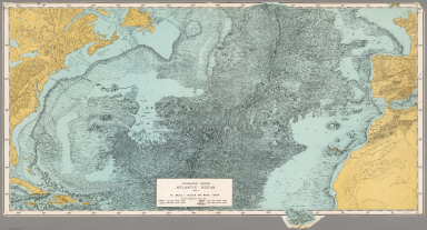
1957 Physiographic Diagram, Atlantic Ocean (S … Separate Map Physiographic Diagram, Atlantic Ocean (S … |

1906 No. 24, Lighthouses and sailing routes : … National Atlas Department of Interior : Atlas of Canada … |

1841 Atlantic Ocean. World Atlas Atlantic Ocean. Engraved by G.W. Boynton … |

1787 The Atlantic Ocean. Regional Atlas The Atlantic Ocean by Governor Pownall, … |

1787 Chart of the Acores (Hawks) Islands. Regional Atlas Chart of the Acores (Hawks) Islands, cal … |

1787 A chart of the Maderas and Canary Island … Regional Atlas A chart of the Maderas and Canary Island … |

1788 The Cape Verd Islands. Regional Atlas The Cape Verd Islands, laid down from th … |

1788 The Bermudas, or Summer's Islands. Regional Atlas The Bermudas, or Summer's Islands. From … |

1850 Atlantic Ocean. School Atlas Atlantic Ocean. Drawn by (to be filled i … |

1827 Gulf-Stream. Physical Atlas Carte du courant qui sort par le Canal d … |

1827 La Manche. Physical Atlas Carte et coupe du Canal de la Manche. Bo … |

1817 N. Atlantic Ocean. World Atlas Chart of North Atlantic Ocean with track … |

1827 Conjecturale de l'Atlantide. Physical Atlas Carte conjecturale de l'Atlantide d'apre … |

1830 Atlantic Ocean. School Atlas Atlantic Ocean, its islands & coasts. En … |

1836 Africa, Atlantic. School Atlas Africa and the Atlantic Ocean. Entered . … |

1831 Atlantic Ocean. World Atlas Chart of the Atlantic Ocean. W.H. Lizars … |

1883 Islands, Atlantic Ocean. World Atlas Islands in the Atlantic Ocean. Letts's p … |

1922 South Atlantic Ocean. World Atlas South Atlantic Ocean on Mercators projec … |

1929 Legend: 4-5. Linee di comunicazione, Oce … World Atlas (Legend) Linee di comunicazione del Ocea … |

1929 4-5. Linee di comunicazione, Oceano Atla … World Atlas Linee di comunicazione del Oceano Atlant … |

1831 South America, Atlantic Ocean. World Atlas South America. Atlantic Ocean. G. Boynto … |

1922 North Atlantic Ocean. World Atlas North Atlantic Ocean on Mercators projec … |

1922 Composite: Atlantic Ocean. World Atlas (Composite of) Section maps of the Atlan … |

1889 Antilia, 1463. Exploration Book The island of Antilia by Benincasa, 1463 … |

1895 Atlantic World Atlas Atlantic Ocean. (Published at the office … |

1881 Atlantischer Ocean. World Atlas Atlantischer Ocean, Meerestiefen und Tel … |

1850 Der Atlantische Ocean. (Atlantic). World Atlas Stieler's Hand-Atlas (No. 41c). Der Atla … |

1853 Der Atlantische Ocean. (Atlantic). World Atlas Stieler's Hand-Atlas (No. 41c). Der Atla … |

1875 Nord-Atlantischer Ocean. World Atlas Nord-Atlantischer Ocean. Entw. & gez. v. … |

1834 Chart Of The South Atlantic Ocean Chart Map Chart Of The South Atlantic Ocean, From … |

1944 Supply Lines to Victory. 25. Battle of t … World Atlas Supply Lines to Victory. 25. Battle of t … |

1856 Atlantic Ocean. Physical Atlas Physical chart of the Atlantic Ocean sho … |

1854 Marine life. Physical Atlas Map of the distribution of marine life, … |