Browse All

1899 24. Ward 23 West Roxbury. City Atlas Part of ward 23, West Roxbury, city of B … |

1899 25. Ward 23 West Roxbury. City Atlas Part of ward 23, West Roxbury, city of B … |

1899 26. Ward 23 West Roxbury. City Atlas Part of ward 23, West Roxbury, city of B … |

1899 27. Ward 23 West Roxbury. City Atlas Part of ward 23, West Roxbury, city of B … |

1899 28. Ward 23 West Roxbury. City Atlas Part of ward 23, West Roxbury, city of B … |

1899 29. Ward 23 West Roxbury. City Atlas Part of ward 23, West Roxbury, city of B … |

1899 30. Ward 23 West Roxbury. City Atlas Part of ward 23, West Roxbury, city of B … |

1899 31. Ward 23 West Roxbury. City Atlas Part of ward 23, West Roxbury, city of B … |

1899 32. Ward 23 West Roxbury. City Atlas Part of ward 23, West Roxbury, city of B … |

1899 33. Ward 25 Brighton. City Atlas Part of ward 25, Brighton, city of Bosto … |

1899 34. Ward 25 Brighton. City Atlas Part of ward 25, Brighton, city of Bosto … |

1899 35. Ward 25 Brighton. City Atlas Part of ward 25, Brighton, city of Bosto … |

1899 36. Ward 25 Brighton. City Atlas Part of ward 25, Brighton, city of Bosto … |

1899 37. Ward 25 Brighton. City Atlas Part of ward 25, Brighton, city of Bosto … |

1899 38. Ward 25 Brighton. City Atlas Part of ward 25, Brighton, city of Bosto … |

1899 39. Ward 24 Brighton. City Atlas Part of ward 24 (i.e. 25?), Brighton, ci … |

1899 40. Ward 25 Brighton. City Atlas Part of ward 25, Brighton, city of Bosto … |

1870 Boston. [State Atlas, World Atlas] Plan of Boston. (with) Map of the countr … |

1880 Boston. World Atlas Plan of Boston. (with) Map of the countr … |

1859 Massachusetts and Rhode Island. World Atlas Map of Massachusetts and Rhode Island. P … |

1879 Text Page: Boston & Maine Railroad. Timetable Map (Text Page to) Boston & Maine Railroad . … |
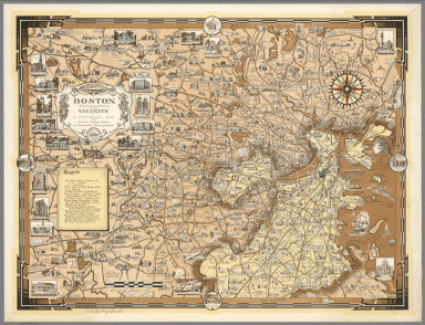
1938 Boston (Massachusetts) and Vicinity. A P … Separate Map Boston (Massachusetts) and Vicinity. A P … |

1871 Boston. State Atlas Map of the compact portions of Boston an … |

1747 Towns, harbours, America, W.I. Geography Book Particular draughts and plans of some of … |

1873 Boston and Adjacent Cities. World Atlas Map of the Compact Portions of Boston an … |

1884 Boston and Adjacent Cities. National Atlas Boston and Adjacent Cities. By H.F. Wall … |

1891 Map of Boston, Massachusetts. 71 World Atlas Map of Boston, Mass. Copyright 1891 by M … |

1930 Boston Common with Surrounding Streets & … Separate Map Map of Boston Common with Surrounding St … |

1846 Massachusetts And Rhode Island. World Atlas Massachusetts And Rhode Island: (with) B … |

1854 Cover: Subscribers to Colton's American … Ephemera (Covers to) Subscribers to Colton's Amer … |

1854 Title Page: Subscribers to Colton's Amer … Ephemera (Title Page to) Subscribers to Colton's … |

1854 Subscribers to Colton's American Atlas. Ephemera Subscribers to Colton's American Atlas a … |

1854 Subscribers to Colton's American Atlas. Ephemera Subscribers to Colton's American Atlas a … |

1854 Subscribers to Colton's American Atlas. Ephemera Subscribers to Colton's American Atlas a … |

1854 Subscribers to Colton's American Atlas. Ephemera Subscribers to Colton's American Atlas a … |

1854 Subscribers to Colton's American Atlas. Ephemera Subscribers to Colton's American Atlas a … |

1860 County Map Of The States Of New York, Ne … World Atlas County Map Of The States Of New York, Ne … |

1860 Plan Of Boston. World Atlas Plan Of Boston. 17. (with) inset Map Of … |

1865 Massachusetts and Rhode Island, Vicinity … World Atlas Colton's Massachusetts and Rhode Island. … |

1865 Boston and Adjacent Cities. World Atlas Colton's Map of Boston and Adjacent Citi … |

1869 Boston and Adjacent Cities. World Atlas Colton's Boston and Adjacent Cities. Pub … |

1874 Boston and Vicinity. World Atlas Map of the Compact Portions of Boston an … |

1924 Massachusetts. National Atlas Commercial Atlas of America. Rand McNall … |

1924 Boston. National Atlas Commercial Atlas of America. Rand McNall … |

1860 Map Of Boston. Case Map Map Of Boston And The Country Adjacent, … |

1836 Massachusetts And Rhode Island. World Atlas Massachusetts And Rhode Island: By H.S. … |

1884 Boston. World Atlas Plan of Boston. (with) Map of the countr … |

1859 Massachusetts And Rhode Island. World Atlas Map of Massachusetts and Rhode Island. P … |

1845 Massachusetts And Rhode Island. World Atlas Massachusetts And Rhode Island: By H.S. … |

1903 Boston. National Atlas Rand, McNally & Co.'s Boston. (with) Env … |