Who What Where WhenREMOVEWHO
WHEN |
REFINE
Browse All : Images of California from 1868
1-47 of 47
Author
[Frey, A.C., Nell, Louis]
Full Title
Topographical Railroad & County Map Of The States Of California And Nevada Compiled from the latest explorations and other official information by L. Nell, N.Y. Published by A.C. Frey & Co 204 Fulton St. New York. General Agents for California A. Roman & Co. 417 & 419 Montgomery St. San Francisco. Ferd. Mayer & Co. Lithographers, 96 Fulton St. N.Y. Entered ... 1868 by Frey & Nell ... New York. (inset) Map of the City of San Francisco, California. (inset) Map Of The Great National Pacific Railroads.
Publisher
A.C. Frey & Co.
Author
Whitney, J.D.
Full Title
(Covers to) The Yosemite Book; A Description of the Yosemite Valley and the Adjacent Region of the Sierra Nevada, and of the Big Trees of California, Illustrated by Maps and Photographs. Geological Survey of California. J.D. Whitney, State Geologist. Published by Authority of the Legislature. New York, Julius Bien. 1868.
Publisher
Julius Bien
Author
Whitney, J.D.
Full Title
(Title Page) The Yosemite Book; A Description of the Yosemite Valley and the Adjacent Region of the Sierra Nevada, and of the Big Trees of California, Illustrated by Maps and Photographs. Geological Survey of California. J.D. Whitney, State Geologist. Published by Authority of the Legislature. New York, Julius Bien. 1868.
Publisher
Julius Bien
Author
Whitney, J.D.
Full Title
(Text) (Title Page Verso) (Table of Contents to) The Yosemite Book; A Description of the Yosemite Valley and the Adjacent Region of the Sierra Nevada, and of the Big Trees of California, Illustrated by Maps and Photographs. Geological Survey of California. J.D. Whitney, State Geologist. Published by Authority of the Legislature. New York, Julius Bien. 1868.
Publisher
Julius Bien
Author
Whitney, J.D.
Full Title
(Table of Contents to and List of Photographs in) The Yosemite Book; A Description of the Yosemite Valley and the Adjacent Region of the Sierra Nevada, and of the Big Trees of California, Illustrated by Maps and Photographs. Geological Survey of California. J.D. Whitney, State Geologist. Published by Authority of the Legislature. New York, Julius Bien. 1868.
Publisher
Julius Bien
Author
Whitney, J.D.
Full Title
(Section Title Page) Photographs and Maps.
Publisher
Julius Bien
Author
[Whitney, J.D., Watkins, C.E.]
Full Title
(View) The Yosemite Valley, from the Mariposa Trail.
Publisher
Julius Bien
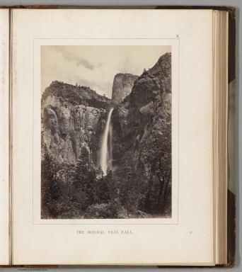
Author
[Whitney, J.D., Watkins, C.E.]
Full Title
(View) The Bridal Veil Fall.
Publisher
Julius Bien
Author
[Whitney, J.D., Watkins, C.E.]
Full Title
(View) El Capitan.
Publisher
Julius Bien
Author
[Whitney, J.D., Watkins, C.E.]
Full Title
(View) El Capitan and Cathedral Rock, View down the Valley.
Publisher
Julius Bien
Author
[Whitney, J.D., Watkins, C.E.]
Full Title
(View) Cathedral Rock, near view from the front.
Publisher
Julius Bien
Author
[Whitney, J.D., Watkins, C.E.]
Full Title
(View) Cathedral Rock and Spires.
Publisher
Julius Bien
Author
[Whitney, J.D., Watkins, C.E.]
Full Title
(View) The Cathedral Spires.
Publisher
Julius Bien
Author
[Whitney, J.D., Watkins, C.E.]
Full Title
(View) The Three Borthers.
Publisher
Julius Bien
Author
[Whitney, J.D., Watkins, C.E.]
Full Title
(View) Sentinel Rock.
Publisher
Julius Bien
Author
[Whitney, J.D., Watkins, C.E.]
Full Title
(View) The Yosemite Falls.
Publisher
Julius Bien
Author
[Whitney, J.D., Watkins, C.E.]
Full Title
(View) The Yosemite Falls, from Sentinel Dome.
Publisher
Julius Bien
Author
[Whitney, J.D., Watkins, C.E.]
Full Title
(View) The North Dome, Royal Arches and Washington Column.
Publisher
Julius Bien
Author
[Whitney, J.D., Watkins, C.E.]
Full Title
(View) The North Dome.
Publisher
Julius Bien
Author
[Whitney, J.D., Watkins, C.E.]
Full Title
(View) The Half Dome.
Publisher
Julius Bien
Author
[Whitney, J.D., Watkins, C.E.]
Full Title
(View) View Up the Canyon of the Illilouette.
Publisher
Julius Bien
Author
[Whitney, J.D., Watkins, C.E.]
Full Title
(View) The Vernal Fall.
Publisher
Julius Bien
Author
[Whitney, J.D., Watkins, C.E.]
Full Title
(View) The Nevada Fall and the Cap of Liberty.
Publisher
Julius Bien
Author
[Whitney, J.D., Watkins, C.E.]
Full Title
(View) The Nevada Fall, near View.
Publisher
Julius Bien
Author
[Whitney, J.D., Watkins, C.E.]
Full Title
(View) Views from Sentinel Dome No. 1.
Publisher
Julius Bien
Author
[Whitney, J.D., Watkins, C.E.]
Full Title
(View) Views from Sentinel Dome No. 2.
Publisher
Julius Bien
Author
[Whitney, J.D., Watkins, C.E.]
Full Title
(View) Views from Sentinel Dome No. 3.
Publisher
Julius Bien
Author
[Whitney, J.D., Watkins, C.E.]
Full Title
(Composite) [Views from Sentinel Dome Nos. 1, 2, 3.; Photographs Nos. 19, 20, and 21.]
Publisher
Julius Bien
Author
[Whitney, J.D., Watkins, C.E.]
Full Title
(View) View Looking towards the Nevada and Merced Falls, from Glacier Point.
Publisher
Julius Bien
Author
[Whitney, J.D., Watkins, C.E.]
Full Title
(View) The Grizzly Giant, Mariposa Grove.
Publisher
Julius Bien
Author
[Whitney, J.D., Watkins, C.E.]
Full Title
(View) Base of the Grizzly Giant.
Publisher
Julius Bien
Author
[Whitney, J.D., Harris, W.]
Full Title
(View) Summit of Mt. Hoffmann.
Publisher
Julius Bien
Author
[Whitney, J.D., Harris, W.]
Full Title
(View) Lake Tenaya.
Publisher
Julius Bien
Author
[Whitney, J.D., Harris, W.]
Full Title
(View) Cathedral Peak, from Soda Springs.
Publisher
Julius Bien
Author
[Whitney, J.D., Harris, W.]
Full Title
(View) Valley of Mr. Lyell, Fork of the Upper Tuolumne.
Publisher
Julius Bien
Author
[Whitney, J.D., King, C., Gardner, J.T.]
Full Title
Map of the Yosemite Valley, from Surveys made by the order of the Commissioners to manage the Yosemite Valley and Mariposa Big Tree Grove, by C. King and J.T. Gardner 1865. Drawn by J.T.G. N.Y. Lithg. Engrg. & Prtg. Co. 16 & 18 Park Place.
Publisher
Julius Bien
Author
[Whitney, J.D., Gardner, J.T., Hoffmann, Chs. F.]
Full Title
Map of a Portion of the Sierra Nevada adjacent to Yosemite Valley, from surveys made by Chs. F. Hoffmann and J.T. Gardner, 1863, 1867. Geological Survey of Califoria, J.D. Whitney, State Geologist.
Publisher
Julius Bien
Author
[Bancroft, H.H., (Knight, W.H.)]
Full Title
(Covers to) Bancroft's Map Of California And Nevada. Published By H.H. Bancroft & Co. Booksellers & Stationers San Francisco Cal. 1868. Entered ... 1868 by H.H. Bancroft & Company ... California.
Publisher
H.H. Bancroft & Co.
Author
[Bancroft, H.H., (Knight, W.H.)]
Full Title
Bancroft's Map Of California And Nevada. Published By H.H. Bancroft & Co. Booksellers & Stationers San Francisco Cal. 1868. Entered ... 1868 by H.H. Bancroft & Company ... California.
Publisher
H.H. Bancroft & Co.
Author
[Doolittle, A.J., Holt, A.J., Ransom, Leander]
Full Title
(Covers to) A New Map Of The States Of California And Nevada Exhibiting the Rivers, Lakes, Bays and Islands, with the principal Towns, Roads, Railroads and Transit Routes to the Silver Mining Districts of Nevada Territory ... Carefully compiled from United States and other Reliable Surveys by Leander Ransom. And A.J. Doolittle, 1868. W. Holt, 411 Kearney St. S.F. Entered ... 1863 by Warren Holt ... California.
Publisher
Warren Holt
Author
[Doolittle, A.J., Holt, A.J., Ransom, Leander]
Full Title
A New Map Of The States Of California And Nevada Exhibiting the Rivers, Lakes, Bays and Islands, with the principal Towns, Roads, Railroads and Transit Routes to the Silver Mining Districts of Nevada Territory ... Carefully compiled from United States and other Reliable Surveys by Leander Ransom. And A.J. Doolittle, 1868. W. Holt, 411 Kearney St. S.F. Entered ... 1863 by Warren Holt ... California.
Publisher
Warren Holt
Author
Mitchell, Samuel Augustus Jr.
Full Title
County map of California (inset maps) 52. Map of the Settlements in the Great Salt Lake Country. Utah. 53. San Francisco Bay and Vicinity. Entered ... 1867 by S. Augustus Mitchell, Jr. ... Pennsylvania.
Publisher
S.A. Mitchell Jr.
Author
Goddard, George H. (George Henry), 1817-1906
Full Title
Birds eye view of the city of San Francisco and surrounding country. Drawn by George H. Goddard. Lith. Britton & Rey, S.F. Entered according to act of Congress in the year 1868 by Snow & May in the ... U.S. District Court for the Northern District of California.
Publisher
Snow & May
Author
Bulkley, Charles S.
Full Title
Map of Lands of the Saucelito Land and Ferry Company As Laid Out Under The Direction of Chas. S. Bulkley C.E. ; L.H. Shortt ; & S.R. Throckmorton, Jr., engineers ; H.A. Lricks (Alricks), Jr. topographer. Scale, 660 ft. to the inch. Drawn on stone by W. Vallance Gray. G.T. Brown & Co. Print.
Publisher
G.T. Brown & Co.
Author
Newport, California
Full Title
(Cover and Deed to) California Map Showing San Francisco, Newport. Rail Road Connections With The Adjacent Country. (with: A Deed for lot 37 in Block 392 in the City of Newport to William H. Carr, of Mount Vernon, Kennebec County, State of Maine).
Publisher
No Publisher
Author
Newport, California
Full Title
California Map Showing San Francisco, Newport. Rail Road Connections With The Adjacent Country. (with: A Deed for lot 37 in Block 392 in the City of Newport to William H. Carr, of Mount Vernon, Kennebec County, State of Maine).
Publisher
No Publisher
Author
[California Geological Survey, Whitney, J.D., Gardner, J.T., Hoffmann, Chs. F.]
Full Title
Map of a Portion of the Sierra Nevada adjacent to Yosemite Valley, from surveys made by Chs. F. Hoffmann and J.T. Gardner, 1863 -1867. Geological Survey of California, J.D. Whitney, State Geologist. J. Bien, Lith. N.Y.
Publisher
Julius Bien
1-47 of 47
|