Who What Where WhenWHERE
WHO
WHEN |
REFINE
Browse All : Images of Canada from 1869
1-10 of 10
Author
Colton, G.W. & C.B.
Full Title
(Covers to) Colton's New Railroad Map Of The United States & Canada, Published by G.W. And C.B. Colton, & Co. 172 William St. New York. 1869. Entered ... 1861, by J.H. Goldthwait ... New York. (inset) Map Of The Great Railroad Routes from the Middle Atlantic Ports To The Mississippi River. (inset) Map Of The Railroads Of New England And Eastern N. York. (inset) The Northern Hemisphere On A Polar Projection, Showing the time on each meridian as compared with Washington noon, and the longest day for different latitudes.
Publisher
G.W. & C.B. Colton.
Author
Colton, G.W. & C.B.
Full Title
Colton's New Railroad Map Of The United States & Canada, Published by G.W. And C.B. Colton, & Co. 172 William St. New York. 1869. Entered ... 1861, by J.H. Goldthwait ... New York. (inset) Map Of The Great Railroad Routes from the Middle Atlantic Ports To The Mississippi River. (inset) Map Of The Railroads Of New England And Eastern N. York. (inset) The Northern Hemisphere On A Polar Projection, Showing the time on each meridian as compared with Washington noon, and the longest day for different latitudes.
Publisher
G.W. & C.B. Colton.
Author
Colton, G.W.
Full Title
Colton's Dominion of Canada, No. 1. The Provinces of Quebec and New Brunswick. Published by G. W & C. B. Colton & Co., No. 172 William St. New York.
Publisher
G. W & C. B. Colton & Co.
Author
Colton, G.W.
Full Title
Colton's Dominion of Canada, No. 2. The Province of Ontario. Published by G. W & C. B. Colton & Co., No. 172 William St. New York.
Publisher
G. W & C. B. Colton & Co.
Author
Colton, G.W.
Full Title
Colton's Dominion of Canada, No. 3. The Provinces of New Brunswick & Nova Scotia and Prince Edward Island. Published by G. W & C. B. Colton & Co., No. 172 William St. New York.
Publisher
G. W & C. B. Colton & Co.
Author
Colton, G.W.
Full Title
Colton's New Brunswick, Nova Scotia, Newfoundland. And Prince Edward Id. Published by G. W & C. B. Colton & Co., No. 172 William St. New York.
Publisher
G. W & C. B. Colton & Co.
Author
[Johnston, Alexander Keith, 1804-1871, Rogers, Henry Darwin, Stanford, Edward]
Full Title
(Covers to) Map Of The United States And Mexico With Canada, New Brunswick, Nova Scotia and Newfoundland, And Parts Of Central America & The West Indies. Constructed From State Documents & Unpublished Materials By Professor H.D. Rogers of Boston U.S. and A. Keith Johnston, F.R.S.E Geographer to the Queen. London; Published by Edward Stanford, 6 Charing Cross, S.W. May 13th. 1861. Additions to 1869.
Publisher
Edward Stanford
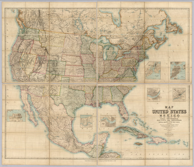
Author
[Alaskan Boundary Tribunal, U.S. Coast Survey]
Full Title
(Facsimile) Tracing of part of "Alaska" shewing "Stakeen (Stickeen) River" from U.S. Coast Survey of 1869. Certified, Domn. Lands Office, Jan. 16th. 1878. The Burland Desbarats Lith. Co. Montreal.
Publisher
(U.S.) Government Printing Office
Author
[Alaskan Boundary Tribunal, Imray, James]
Full Title
(Facsimile) North Pacific (portion), London Published by James Imray and Son, 89 Minories and Tower Hill, 1869. Alaskan Boundary Tribunal, 1903. 33. Andrew B. Graham. Photo-Litho. Washington.D.C.
Publisher
Government Printing Office
1-10 of 10
|