Browse All

1886 Hawaii, New Zealand, Fiji,Tonga, Samoa, … World Atlas Colton's Hawaiian Group or Sandwich Isla … |

1874 Hawaii, New Zealand, Fiji,Tonga, Samoa, … World Atlas Colton's Hawaiian Group or Sandwich Isla … |

1901 Islands of Importance. World Atlas Islands of Importance not delineated at … |

1880 New Zealand. World Atlas New Zealand. W. Swan Sonnenschein & Alle … |

1880 New Zealand. World Atlas New Zealand. W. Swan Sonnenschein & Alle … |

1901 Tasmania, Fiji. World Atlas Tasmania. Fiji Archipelago. London atlas … |

1845 Tanoa, King of Ambau. Exploration Book Tanoa, King of Ambau. Drawn by A.T. Agat … |

1845 Rewa. Exploration Book Town of Rewa. Drawn by A.T. Agate. W.G. … |

1845 Garaningiou's house, Feejee. Exploration Book Interior of Garaningiou's house, Feejee. … |

1845 Observatory Peak, Feejee Is. Exploration Book Observatory Peak, Feejee Is. (Drawn by) … |

1845 Valley of Voona, Feejee Is. Exploration Book Valley of Voona, Feejee Is. (Drawn by) A … |

1906 East India Islands (Borneo, Sumatra, Jav … World Atlas East India Islands (Borneo, Sumatra, Jav … |

1827 Iles Fidji. Oceanique no. 40. World Atlas Iles Fidji. Oceanique no. 40. (Dresse pa … |

1883 Polynesia, Islands of Pacific. World Atlas Polynesia, or Islands of the Pacific Oce … |

1845 Queen of Rewa. Exploration Book Queen of Rewa. Drawn by A.T. Agate. Welc … |

1845 Vendovi. Exploration Book Vendovi. Drawn by A.T. Agate. J.W. Parad … |

1845 Club dance, Feejee. Exploration Book Club dance, Feejee. (Drawn by) J. Drayto … |

1845 Biche-de-mar house. Exploration Book Biche-de-mar house. Drawn by A.T. Agate. … |

1845 Tombs, Muthuata I., Feejee Exploration Book Tombs at Muthuata I., Feejee. Drawn by A … |

1895 Polynesia Groups, S Polar Regions. World Atlas Polynesian Groups (composed of) Fiji, Vi … |

1881 Sudpolarregion, Polynesische Inselgruppe … World Atlas Karte der Sudpolarregion. Polynesische I … |

1840 Island of Natrai, Island of Angau (Gau o … Chart Map Island of Natrai, Feejee (Fiji) Group, b … |

1840 Island of (Keteira), Island of Totoia (T … Chart Map Island of Moala (Keteira), Feejee (Fiji) … |

1840 Harbours of Mbenga, Rewa-Roads, South Si … Chart Map Island and Harbours of Mbenga, South Sid … |

1840 Eastern Group, Fiji. Chart Map Eastern Group, Feejee (Fiji) Islands, by … |

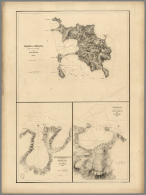
1840 Western End of Viti Levu, with the Ship … Chart Map Western End of Viti Levu, with the Ship … |
1840 Island of Yendua, Nucumurry Harbour, Wai … Chart Map Island of Yendua, Feejee (Fiji) Group, b … |

1841 Raritona Harbour, Emmons Bay, Island of … Chart Map Raritona Harbour, Island of Ya-Asaua (Ya … |

1841 Harbour of (Macuata-i-wai), Tibethe & Vi … Chart Map Harbour of Muthuata (Macuata-i-wai), Nor … |

1841 Eastern Group, Sheet 1, Feejee (Fiji) Is … Chart Map Eastern Group, Sheet 1, Feejee (Fiji) Is … |

1841 Eastern Group, Sheet 2, Feejee (Fiji) Is … Chart Map Eastern Group, Sheet 2, Feejee (Fiji) Is … |

1841 Whippy Harbour, Suva Harbour, Granby Har … Chart Map Whippy Harbour, South Side of Viti Levu, … |

1841 Island of Ovolau (Ovalau), Feejee (Fiji) … Chart Map Island of Ovolau (Ovalau), Feejee (Fiji) … |

1841 Asaua or Western Group, Feejee (Fiji) Is … Chart Map Asaua or Western Group, Feejee (Fiji) Is … |

1841 Port Safety, Island of Kea (Kioa); Fawn … Chart Map Port Safety, Island of Kea (Kioa), East … |

1841 Island of Goro (Koro), Feejee (Fiji) Gro … Chart Map Island of Goro (Koro), Feejee (Fiji) Gro … |

1841 North Side of Vanu Levu from Aramula Pas … Chart Map Channel on the North Side of Vanu Levu f … |

1841 North Side of Viti Levu from Sakau Bay t … Chart Map North Side of Viti Levu with the Ship Pa … |

1841 M'Bua or Sandalwood Bay (Savusavu Bay), … Chart Map M'Bua or Sandalwood Bay, Island of Vanua … |

1841 Channel of the North Side of Vanua Levu … Chart Map Channel of the North Side of Vanua Levu … |

1840 Channel on the South Western Side of Van … Chart Map Channel on the South Western Side of Van … |

1777 Harvey's, Palmerston, Turtle, Savage isl … Exploration Book Harvey's Isle. Palmerston Isle. Turtle I … |

1967 Map Title Page: 236-237. Australia, Ocea … World Atlas (Map Title Page) 236-237. Australia, Oce … |
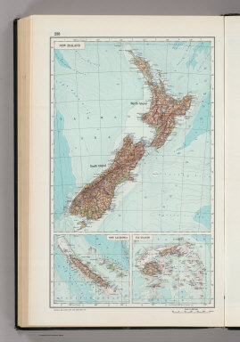
1967 238. New Zealand, New Caledonia, Fiji. T … World Atlas 238. New Zealand, New Caledonia, Fiji Is … |

1869 Hawaii, New Zealand, Fiji,Tonga, Samoa, … World Atlas Colton's Hawaiian Group or Sandwich Isla … |

1897 New Zealand, Tasmania, Fiji. World Atlas Rand, McNally & Co.'s indexed atlas of t … |

1912 Oceania. World Atlas Oceania. (with) Western Australia. (with … |

1879 Oceania. World Atlas Oceania. (with) Western Australia. (with … |

1893 Oceania. World Atlas Oceania. (with) Western Australia. (with … |