Who What Where WhenREMOVEWHAT
|
REFINE
Browse All : Images of Galapagos Islands
1-13 of 13
Author
[Brue, Adrien Hubert, 1786-1832, Picquet, C.]
Full Title
Carte generale de l'Amerique Meridionale et des iles qui en dependent. (with) Iles Galapagos. (with isles Pierre I and Alexandre I). (with) Iles Shetland et Orcades Meridionale, d'apres le Capne. Weddell en 1825. (with) Archipel de Sandwich. (with Isle St. Paul). (with Isle de la Trinite). Dressee par A. Brue, Geographe du Roi. Augmentee et rectifiee pour des limites par Ch. Picquet, Geographe du Roi et du Duc d'Orleans. Paris, 1839. Chez Ch. Picquet, Quai Conti No. 17, pres du Pont des Arts.
Publisher
C. Picquet
Author
Brue, Adrien Hubert, 1786-1832
Full Title
Carte generale de l'Amerique Meridionale et des iles qui en dependent. (with) Iles Galapagos. (with isles Pierre I and Alexandre I). (with) Iles Shetland et Orcades Meridionale, d'apres le Capne. Weddell en 1825. (with) Archipel de Sandwich. (with Isle St. Paul). (with Isle de la Trinite). Dressee par A. Brue, Geographe du Roi. Paris, 1826. Chez l'Auteur, rue des Macons-Sorbonne, no. 9, et chez les principaux m(archan)ds de cartes geographiques.
Publisher
A. Brue
Author
Stanford, Edward
Full Title
Colombia, Ecuador and Peru, also Panama. (with Panama Canal Zone). (with) Galapagos Islands, Colon. London: Edward Stanford, Ltd., 12, 13, & 14, Long Acre, W.C. London atlas series. Stanford's Geographical Establishment, London. (1922?)
Publisher
Edward Stanford
Author
Stanford, Edward
Full Title
(Covers to) Colombia, Ecuador and Peru, also Panama. London: Edward Stanford, Ltd., 12, 13, & 14, Long Acre, W.C. London atlas series. Stanford's Geographical Establishment, London. (1922?)
Publisher
Edward Stanford
Author
Stanford, Edward
Full Title
(Inside Covers to) Colombia, Ecuador and Peru, also Panama. London: Edward Stanford, Ltd., 12, 13, & 14, Long Acre, W.C. London atlas series. Stanford's Geographical Establishment, London. (1922?)
Publisher
Edward Stanford
Author
Instituto Geografico Militar
Full Title
Mapa Geographico de la Republica del Ecuador.
Publisher
Instituto Geografico Militar
Author
W. & A.K. Johnston Limited
Full Title
South America (Physical). Colombia, Equador, Galapagos Islands.
Publisher
W. & A.K. Johnston Limited
Author
Vancouver, George, 1757-1798
Full Title
A Chart of the Sandwich Islands as Surveyed during the Visits of His Majesty's Sloop Discovery and Armed Tender Chatham Commanded by George Vancouver Esq. in the Years 1792, 1793 & 1794, and prepared under his immediate inspection by Lieut. Joseph Baker. Engraved by J. Warner. 15. (with) Part of the Gallapagos Isles (and) the Island of Cocoas. London: Published May 1st, 1798, by J. Edwards Pall Mall & G. Robinson Paternoster Row.
Publisher
G.G. & J. Robinson
Author
Vancouver, George, 1757-1798
Full Title
Views of the Sandwich and other Islands. 16. W. Alexander delt. from Sketches made on the spot. London: Published May 1st 1798, by J. Edwards Pall Mall and G. Robinson Paternoster Row. B.T. Pouncy sculp.
Publisher
G.G. & J. Robinson
Author
Vandermaelen, Philippe, 1795-1869
Full Title
Iles Galapagos. Oceanique no. 17. (Dresse par Ph. Vandermaelen, lithographie par H. Ode. Sixieme partie. - Oceanique. Bruxelles. 1827)
Publisher
Ph. Vandermaelen
Author
Bowen, Emanuel
Full Title
A new & accurate map of Mexico or New Spain together with California, New Mexico &c. Drawn from the best modern maps & charts & regulated by astronl. observns. By Eman: Bowen. (London: Printed for William Innys, Richard Ware, Aaron Ward, J. and P. Knapton, John Clarke, T. Longman and T. Shewell, Thomas Osborne, Henry Whitridge ... M.DCC.XLVII)
Publisher
William Innys [et al.]
Author
USSR (Union of Soviet Socialist Republics).
Full Title
(Map Title Page) 221-222. South America, Political. 223. Buenos Aires, Galapagos, Falklands, Tierra del Fuego.
Publisher
USSR
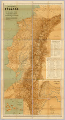
Author
Wolf, Teodoro
Full Title
Carta Geografica del Ecuador por Dr. Teodoro Wolf, publicada por orden del Supremo Gobierno de la Republica y Trabajada Bajo las Presidencias de los EE. Senores Dr. D.J.M. Placido Caamano y Dr. D. Antonio Flores. 1892 ... Instituto geografico de H. Wagner & E. Debes en Leipzig. (with) La Region Oriental Del Ecuador. (with) Archipielago De Galapagos.
Publisher
Instituto geografico de H. Wagner & F. Debes.
1-13 of 13
|