Browse All

1858 Rio Colorado of the West. Exploration Book Explorations and Surveys. War Department … |

1858 Geological Map ... Rio Colorado of the W … Exploration Book Geological Map No. 2. Prepared by J.S. N … |

1875 Grand Canon, Colorado River. Exploration Book Grand Canon, Colorado River. (1875) |

1875 Perched rock, Rocker Creek, Arizona. Exploration Book Perched rock, Rocker Creek, Arizona. (18 … |

1895 Lagoon, Kaibab. Exploration Book Lagoon on the Kaibab. Moran. (1895) |

1895 Grand Canyon, Toroweap. Exploration Book Panorama. Upper view looking east, with … |

1895 Little Colorado mouth. Exploration Book At the mouth of the Little Colorado. (J. … |

1895 Head of Grand Canyon. Exploration Book Head of the Grand Canyon. (1895) |

1895 Inner Gorge. Exploration Book The Inner Gorge. (1895) |

1895 Alcove, Red Wall. Exploration Book An alcove in the Red Wall. (1895) |

1895 Grand Canyon, Amphitheatre, Sculptured B … Exploration Book The Grand Canyon of the Colorado, showin … |

1895 Grand Canyon. Exploration Book The Grand Canyon. (1895) |

1895 Gable with pinnacles. Exploration Book A gable with pinnacles (Grand Canyon, Ar … |

1895 Niches or panels, Red Wall limestone. Exploration Book Niches or panels in the Red Wall limesto … |

1895 Curves, projecting cusps of the walls. Exploration Book Rounded inward curves and projecting cus … |

1895 Eastern Temple. Exploration Book The Eastern Temple. (1895) |

1895 Western Temple. Exploration Book The Western Temple. (1895) |

1895 Granite Falls, Kaibab. Exploration Book Granite Falls, Kiabab (i.e. Kaibab) Divi … |

1895 Dikes in Canyon wall. Exploration Book Dikes in the Canyon wall. (1895) |

1895 Pinnacles of the Kaibab. Exploration Book Pinnacles of the Kaibab. H.H. Nichols. ( … |

1895 Vishnu's Temple. Exploration Book Vishnu's Temple. (1895) |

1895 Key to panorama from Point Sublime looki … Exploration Book Key to the panorama from Point Sublime-- … |

1895 Key to panorama from Point Sublime looki … Exploration Book Key to the panorama from Point Sublime-- … |

1895 Key to panorama from Point Sublime looki … Exploration Book Key to the panorama from Point Sublime-- … |

1895 Grand Canon, foot of the Toroweap lookin … Exploration Book Grand Canyon at the foot of the Toroweap … |

1895 Great unconformity, head of Grand Canyon … Exploration Book The great unconformity at the head of th … |

1929 142. Colo., Kans. World Atlas Stati Uniti, United States of America, C … |

1889 Mouth of the Lower Grand Canon. Exploration Book Mouth of the Lower Grand Canon of the Co … |

1889 Grand Canon from Sheavwitz Crossing. Exploration Book View looking south into the Grand Canon … |

1889 Grand Canon near Kanab Wash. Exploration Book Grand Canon of the Colorado River, near … |

1889 Grand Canon near Paria Creek. Exploration Book Grand Canon of the Colorado, near Paria … |

1889 Colorado River party, Diamond Creek. Exploration Book Colorado River party reaching mouth of D … |

1889 Map, river and land parties, exploring G … Exploration Book Map showing routes of the river and land … |
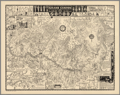
1931 Grand Canyon, 1931 Separate Map Grand Canyon. (Drawn by) Jo Mora. Copyri … |

1931 Grand Canyon Separate Map Grand Canyon. (Drawn by) Jo Mora. Copyri … |

1882 Cover: Tertiary history, Grand Canon Dis … Geologic Atlas (Covers to) Department Of The Interior, … |

1882 Title Page: Tertiary history of the Gran … Geologic Atlas (Title Page to) Department Of The Interi … |

1882 Index: Tertiary history, Grand Canon Dis … Geologic Atlas (Index to) Department Of The Interior, U … |

1882 Geological Map Of The Western Part Of Th … Geologic Atlas Geological Map Of The Western Part Of Th … |

1882 Sketch Map ... showing The Faults of the … Geologic Atlas Sketch Map of the Western Part of the Pl … |

1882 Looking up the Toroweap from Vulcan's Th … Geologic Atlas Looking up the Toroweap from Vulcan's Th … |

1882 Grand Canon, foot of the Toroweap lookin … Geologic Atlas The Grand Canon at the foot of the Torow … |

1882 Map Of The Uinkaret Plateau. North Half. … Geologic Atlas Map Of The Uinkaret Plateau. North Half. … |

1882 Map Of The Uinkaret Plateau. South Half. Geologic Atlas Map Of The Uinkaret Plateau. South Half. … |

1882 Composite: Uinkaret Plateau. N. & S. hal … Geologic Atlas (Composite) Map Of The Uinkaret Plateau. … |

1882 Views looking east and south from Mt. Tr … Geologic Atlas Views looking east and south from Mt. Tr … |

1882 Views from Mt. Trumbull and Mt. Emma. Geologic Atlas Views from Mt. Trumbull and Mt. Emma. W( … |

1882 Geologic Map Of The Southern Part Of The … Geologic Atlas Geologic Map Of The Southern Part Of The … |

1882 Geologic Map Of The Southern Part Of The … Geologic Atlas Geologic Map Of The Southern Part Of The … |

1882 Geologic Map Of The Southern Part Of The … Geologic Atlas Geologic Map Of The Southern Part Of The … |