Who What Where WhenREMOVE |
REFINE
Browse All : Images of Great Lakes
1-12 of 12
Author
Shell Oil Company
Full Title
Shell Map of North Central States (cover title). Shell Sectional Map No. 6 - North Central States. DD-2-1956-2.
Publisher
Shell Oil Company
Author
[Bayer, Herbert, Container Corporation of America]
Full Title
Eastern U.S.A.
Publisher
Container Corporation of America
Author
Colton, G.W. & C.B.
Full Title
Map showing the Route of the Duluth & Winnipeg Railroad And Its Connections. Prepared By G.W. & C.B. Colton & Co. 182 William Street New York. Entered ... 1881 by G.W. & C.B. Colton & Co. ... Washington.
Publisher
G.W. & C.B. colton & Co.
Author
[Bourquin, Frederick, Mitchell, Samuel Augustus, Tanner, Henry S.]
Full Title
Canada West, formerly Upper Canada. Published By S. Augustus Mitchell, N.E. corner of Market & 7th Streets. Entered according to Act of Congress in the 1844, by H.N. Burroughs, - in the Clerk's Office of the District Court of the Eastern District of Pennsylvania. 4.
Publisher
S. Augustus Mitchell.
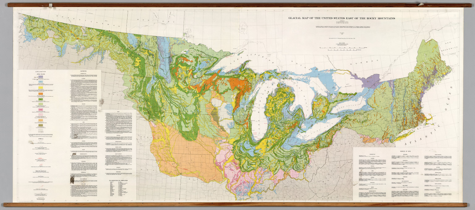
Author
[The Geological Society of America, Flint, Richard F.]
Full Title
Glacial Map of the United States East of the Rocky Mountains.
Publisher
The Geological Society of America
Author
[Canada. Department of Interior, Chalifour, J.E.]
Full Title
Canals, Lighthouses and sailing routes on St. Lawrence River & Great Lakes. (on upper right margin) Sailing routes. Atlas of Canada. (to accompany) Department of the Interior Canada. Atlas Of Canada, 1915. (inset) Lighthouses and sailing routes on St. Lawrence River from Montreal to Quebec.
Publisher
Department of Interior
Author
Mitchell, Samuel Augustus
Full Title
Canada West, formerly Upper Canada. Philadelphia, Published By Charles Desilver, No. 714 Chesnut Street. Entered according to Act of Congress in the year 1859 by Charles Desilver in the Clerk's office if the District Court of the Eastern District of Pennsylvania. 4.
Publisher
Charles Desilver.
Author
[Paullin, Charles O., Wright, John K.]
Full Title
Plate 20. Cartography 1492-1867. Hondius Map, 1630. Sanson, 1656. Jesuit Map 1672. Raffeix Map, 1688. (Facsimiles).
Publisher
[Carnegie Institution of Washington, American Geographical Society of New York]
Author
Bradford, Thomas G.
Full Title
Michigan and the Great Lakes. G.W. Boynton & Co. Sc. (to accompany) A Comprehensive Atlas, Geographical, Historical & Commercial. By T.G. Bradford. William D. Ticknor, Boston. Wiley & Long, New-York. Entered ... 1835, by Thos. G. Bradford ... Massachusetts.
Publisher
[William D. Ticknor, Wiley & Long]
Author
Polish Army Topography Service
Full Title
United States of America - Great Lakes. Pergamon World Atlas. Pergamon Press, Ltd. & P.W.N. Poland 1967. Sluzba Topograficzna W.P.
Publisher
Pergamon Press
Author
Hammond, C.S.
Full Title
The Northern and Northwestern Lakes including Canals and Tributary Navigable Streams.
Publisher
Garden City Publishing Company, Inc.
Author
Mitchell, Samuel Augustus
Full Title
Canada West, formerly Upper Canada. Philadelphia, Published By Charles Desilver, No. 714 Chestnut Street. Entered according to Act of Congress in the year 1856 by Charles Desilver in the Clerk's office if the District Court of the Eastern District of Pennsylvania. 4.
Publisher
Charles Desilver.
1-12 of 12
|