Who What Where WhenREMOVEWHAT
|
Author
Vandermaelen, Philippe, 1795-1869
Full Title
Assam et Boutan. Asie no. 84. (Dresse par Ph. Vandermaelen, lithographie par H. Ode. Deuxieme partie. - Asie. Bruxelles. 1827)
Publisher
Ph. Vandermaelen
Author
Vandermaelen, Philippe, 1795-1869
Full Title
Guzerate, Chandeish et Aurungabad. Asie no. 93. (Dresse par Ph. Vandermaelen, lithographie par H. Ode. Deuxieme partie. - Asie. Bruxelles. 1827)
Publisher
Ph. Vandermaelen
Author
Vandermaelen, Philippe, 1795-1869
Full Title
Malwa, Berar et Beeder. Asie no. 94. Dressee et dessinee par P. Vandermaelen. Dessinee sur pierre et Lithog(raph)ie par H. Ode. Aout 1825. (Deuxieme partie. - Asie. Bruxelles. 1827)
Publisher
Ph. Vandermaelen
Author
Vandermaelen, Philippe, 1795-1869
Full Title
Bengale. Asie no. 95. (Dresse par Ph. Vandermaelen, lithographie par H. Ode. Deuxieme partie. - Asie. Bruxelles. 1827)
Publisher
Ph. Vandermaelen
Author
Arrowsmith, Aaron Jr.
Full Title
India and the Birman Empire with part of China &c. Indae cum Regionibus et Insulis adjacentibus, Sive Oriens ab Indo fluvio ad Oceanum usque Veteribus notus. London, Published Jany. 2, 1828 by A. Arrowsmith Hydrographer to His Majesty, No. 10, Soho Square.
Publisher
A. Arrowsmith
Author
[Delavault, A., Vandermaelen, Philippe, 1795-1869]
Full Title
Bejapoor. Asie no. 102. (Dresse par Ph. Vandermaelen, lithographie par H. Ode. Deuxieme partie. - Asie. Bruxelles. 1827)
Publisher
Ph. Vandermaelen
Author
Vandermaelen, Philippe, 1795-1869
Full Title
Hyderabad et Mysore. Asie no. 103. (Dresse par Ph. Vandermaelen, lithographie par H. Ode. Deuxieme partie. - Asie. Bruxelles. 1827)
Publisher
Ph. Vandermaelen
Author
Vandermaelen, Philippe, 1795-1869
Full Title
Iles Maldives et Laquedives. Asie no. 107. Dressee et dee. par Vandermaelen. La lettre par Fs. Charles. Dessee. sur pierre et Lithogree. par H. Ode. Juin 1825. (Deuxieme partie. - Asie. Bruxelles. 1827)
Publisher
Ph. Vandermaelen
Author
Vandermaelen, Philippe, 1795-1869
Full Title
Partie de l'Inde et Ile de Ceylan. Asie no. 108. Dressee et dessinee par Ph. Vandermaelen. La lettre par Fis. Charles. Dessee. sur pierre et Lithographie par H. Ode. Juillet 1825. (Deuxieme partie. - Asie. Bruxelles. 1827)
Publisher
Ph. Vandermaelen
Author
[Dower, John, Higgins, W.M.]
Full Title
India.
Publisher
[W.S. Orr, Chambers, W. & R.]
Author
Arrowsmith, John
Full Title
India, By J. Arrowsmith. (Map) 30. London, Pubd. 15 Feby. 1842, by J. Arrowsmith, 10 Soho Square.
Publisher
John Arrowsmith
Author
Cornell, S. S. (Sarah S.)
Full Title
Greece, Turkey in Asia and Persia. India. Entered ... 1856, by S.S. Cornell ... Southern District of New York. New York: D. Appleton & Co., 443 & 445 Broadway. (1864)
Publisher
Appleton & Co.
Author
Lattre, Jean
Full Title
Les Indes Orientales et leur archipel. A Paris, ches Lattre. Avec priv. (ca. 1800)
Publisher
C.F. Delamarche
Author
[J. & G. Menzies, Thomson, John]
Full Title
Hindoostan. (with) Isle of Ceylon. J. & G. Menzies sculpt., Edinr. (Drawn & engraved for Thomson's New general atlas, 1817)
Publisher
[Baldwin, Cradock, and Joy, John Cumming, John Thomson]
Author
Thomson, John
Full Title
Northern Hindostan. (with) Cabul. (with) Napaul. S.J. Neele sculp., 352 Strand. Drawn & engraved for Thomson's New general atlas, 1817.
Publisher
[Baldwin, Cradock, and Joy, John Cumming, John Thomson]
Author
Thomson, John
Full Title
Southern Hindostan. Neele sculpt. Drawn & engraved for Thomson's New general atlas, 1816.
Publisher
[Baldwin, Cradock, and Joy, John Cumming, John Thomson]
Author
[Lapie, Alexandre Emile, Lapie, M. (Pierre), 1779-1850]
Full Title
Carte de l'Inde en deca et au dela du Gange. Dressee par M. Lapie, 1er. Geographe du Roi et M. Lapie Fils, Geographe de S.A.R.M. le Dauphin. Paris, 1829. Chez Eymery Fruger et Cie., Rue Mazarine No. 30. La gravure dirigee et executee par Lallemand.
Publisher
Eymery Fruger et Cie
Author
[Covens et Mortier, Lisle, Guillaume de, 1675-1726]
Full Title
Carte des Indes et de la Chine. Dressee sur plusieurs relations particulieres rectifiee par quelques observations par Guillaume de l'Isle de l'Academie Royale des Sciences. A Amsterdam, Chez Jean Covens et Corneille Mortier. (1742)
Publisher
Covens & Mortier
Author
[Covens et Mortier, Lisle, Guillaume de, 1675-1726]
Full Title
Carte des Cotes de Malabar et de Coromandel, presentee au Roy. Par Guillaume de l'Isle. A Amsterdam, Chez J. Covens et C. Mortier, Geographes. (Title in upper margin:) Orarum Malabariae, Coromandelae, &c. tabula accuratissima. (1742)
Publisher
Covens & Mortier
Author
Lizars, Daniel
Full Title
Hindostan. (with) Isle of Ceylon. Published by D. Lizars, Edinburgh. (1831?)
Publisher
[John Hamilton, W. Curry, Jun. & Co., Whittaker, Treacher & Co.]
Author
Letts, Son & Co.
Full Title
General map of India. Letts's popular atlas. Letts, Son & Co. Limited, London. (1883)
Publisher
Letts, Son & Co.
Author
Letts, Son & Co.
Full Title
Statistical & general map of India. No. 1. Letts's popular atlas. Letts, Son & Co. Limited, London. (1883)
Publisher
Letts, Son & Co.
Author
Letts, Son & Co.
Full Title
Statistical & general map of India. No. 2. Letts's popular atlas. Letts, Son & Co. Limited, London. (1883)
Publisher
Letts, Son & Co.
Author
Letts, Son & Co.
Full Title
Statistical & general map of India. No. 3. Letts's popular atlas. Letts, Son & Co. Limited, London. (1883)
Publisher
Letts, Son & Co.
Author
Letts, Son & Co.
Full Title
Statistical & general map of India. No. 4. Letts's popular atlas. Letts, Son & Co. Limited, London. (1883)
Publisher
Letts, Son & Co.
Author
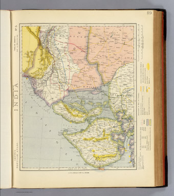
Letts, Son & Co.
Full Title
Statistical & general map of India. No. 5. Letts's popular atlas. Letts, Son & Co. Limited, London. (1883)
Publisher
Letts, Son & Co.
Author
Letts, Son & Co.
Full Title
Statistical & general map of India. No. 6. Letts's popular atlas. Letts, Son & Co. Limited, London. (1883)
Publisher
Letts, Son & Co.
Author
Letts, Son & Co.
Full Title
Statistical & general map of India. No. 7. Letts's popular atlas. Letts, Son & Co. Limited, London. (1883)
Publisher
Letts, Son & Co.
Author
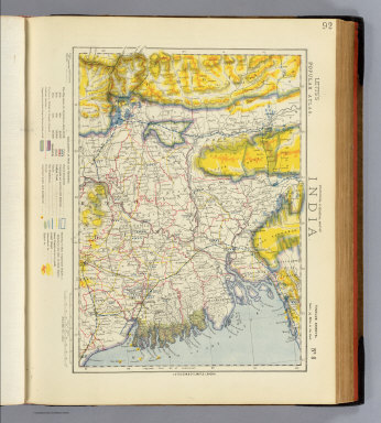
Letts, Son & Co.
Full Title
Statistical & general map of India. No. 8. Letts's popular atlas. Letts, Son & Co. Limited, London. (1883)
Publisher
Letts, Son & Co.
Author
Letts, Son & Co.
Full Title
Statistical & general map of India. No. 9. Letts's popular atlas. Letts, Son & Co. Limited, London. (1883)
Publisher
Letts, Son & Co.
Author
Letts, Son & Co.
Full Title
Statistical & general map of India. No. 10. Letts's popular atlas. Letts, Son & Co. Limited, London. (1883)
Publisher
Letts, Son & Co.
Author
Letts, Son & Co.
Full Title
Statistical & general map of India. No. 11. Letts's popular atlas. Letts, Son & Co. Limited, London. (1883)
Publisher
Letts, Son & Co.
Author
Letts, Son & Co.
Full Title
Plan of the city of Calcutta. Letts's popular atlas. Letts, Son & Co. Limited, London. (1883)
Publisher
Letts, Son & Co.
Author
Robert Laurie & James Whittle
Full Title
(A new map of Hindoostan from the latest authorities. North half. Chiefly from the actual surveys made by major James Rennell, Surveyor to the Hble. East India Company, of the Bengal Provinces, and of the countries lying between them and Delhy; the whole exhibiting all the military roads and passes, as well as the most accurate division of the British possessions in the East Indies. London, Published by Laurie & Whittle, 53, Fleet Street, 12th May, 1794. 2nd editn. corrected 1804)
Publisher
Laurie & Whittle
Author
[Rennell, James, 1742-1830, Robert Laurie & James Whittle]
Full Title
A new map of Hindoostan from the latest authorities. (South half). Chiefly from the actual surveys made by major James Rennell, Surveyor to the Hble. East India Company, of the Bengal Provinces, and of the countries lying between them and Delhy; the whole exhibiting all the military roads and passes, as well as the most accurate division of the British possessions in the East Indies. London, Published by Laurie & Whittle, 53, Fleet Street, 12th May, 1794. 2nd editn. corrected 1804.
Publisher
Laurie & Whittle
Author
[Rennell, James, 1742-1830, Robert Laurie & James Whittle]
Full Title
(Composite of) A new map of Hindoostan from the latest authorities. Chiefly from the actual surveys made by major James Rennell, Surveyor to the Hble. East India Company, of the Bengal Provinces, and of the countries lying between them and Delhy; the whole exhibiting all the military roads and passes, as well as the most accurate division of the British possessions in the East Indies. London, Published by Laurie & Whittle, 53, Fleet Street, 12th May, 1794. 2nd editn. corrected 1804.
Publisher
Laurie & Whittle
Author
[Rennell, James, 1742-1830, Robert Laurie & James Whittle]
Full Title
A map of the north part of Hindostan or a geographical survey of the provinces of Bengal, Bahar, Awd, Ellahabad, Agra and Delhi. By Major James Rennell, F.R.S., Engineer, Surveyor General to the Honourable the East India Company. Published 12th May, 1794 by Laurie & Whittle, 53, Fleet Street, London.
Publisher
Laurie & Whittle
Author
Robert Laurie & James Whittle
Full Title
(An actual survey, of the provinces of Bengal, Bahar &c. North half. By Major James Rennell, Engineer, Surveyor General to the Honourable the East India Company, published by permission of the court of directors, from a drawing in their possession; by A. Dury. Wm. Haydon sculpt. Published 12th May, 1794, by Laurie & Whittle, 53 Fleet Street, London)
Publisher
Laurie & Whittle
Author
[Dury, Andrew, Rennell, James, 1742-1830, Robert Laurie & James Whittle]
Full Title
An actual survey, of the provinces of Bengal, Bahar &c. (South half). By Major James Rennell, Engineer, Surveyor General to the Honourable the East India Company, published by permission of the court of directors, from a drawing in their possession; by A. Dury. Wm. Haydon sculpt. Published 12th May, 1794, by Laurie & Whittle, 53 Fleet Street, London.
Publisher
Laurie & Whittle
Author
[Dury, Andrew, Rennell, James, 1742-1830, Robert Laurie & James Whittle]
Full Title
(Composite of) An actual survey, of the provinces of Bengal, Bahar &c. By Major James Rennell, Engineer, Surveyor General to the Honourable the East India Company, published by permission of the court of directors, from a drawing in their possession; by A. Dury. Wm. Haydon sculpt. Published 12th May, 1794, by Laurie & Whittle, 53 Fleet Street, London.
Publisher
Laurie & Whittle
Full Title
(A map of the provinces of Delhi, Agrah, Oude, and Ellahabad, comprehending the countries lying between Delhi, and the Bengal Provinces. North half. Surveyed by Major James Rennell, Surveyor General to the Honourable East-India Company, and published by order of the court of directors of said company. By Andrew Dury, published 12th May, 1794 by Laurie & Whittle, 53, Fleet Street, London. Wm. Haydon sculpt.)
Publisher
Laurie & Whittle
Author
[Dury, Andrew, Rennell, James, 1742-1830, Robert Laurie & James Whittle]
Full Title
A map of the provinces of Delhi, Agrah, Oude, and Ellahabad, comprehending the countries lying between Delhi, and the Bengal Provinces. (South half). Surveyed by Major James Rennell, Surveyor General to the Honourable East-India Company, and published by order of the court of directors of said company. By Andrew Dury, published 12th May, 1794 by Laurie & Whittle, 53, Fleet Street, London. Wm. Haydon sculpt.
Publisher
Laurie & Whittle
Author
[Dury, Andrew, Rennell, James, 1742-1830, Robert Laurie & James Whittle]
Full Title
(Composite of) A map of the provinces of Delhi, Agrah, Oude, and Ellahabad, comprehending the countries lying between Delhi, and the Bengal Provinces. Surveyed by Major James Rennell, Surveyor General to the Honourable East-India Company, and published by order of the court of directors of said company. By Andrew Dury, published 12th May, 1794 by Laurie & Whittle, 53, Fleet Street, London. Wm. Haydon sculpt.
Publisher
Laurie & Whittle
Author
Robert Laurie & James Whittle
Full Title
A new map of the Jaghir Lands on the coast of Coromandel, or the territory belonging to the East India Company round Madras. From actual survey in the possession of the company. Published 12th May, 1794, by Laurie & Whittle, 53, Fleet Street, London.
Publisher
Laurie & Whittle
Author
Arrowsmith, Aaron
Full Title
Hindoostan. From Arrowsmith's map of Asia. Ruld. by Hooker. Scoles sculp. (Published by John Conrad & Co., Philadelphia. 1804)
Publisher
J. Conrad
Author
Arrowsmith, Aaron
Full Title
Hindoostan. From Arrowsmith's map of Asia. Scoles sculp. (Boston: Published by Thomas & Andrews. 1812)
Publisher
Thomas & Andrews
Author
[Bartholomew, J. G. (John George), 1860-1920, John Bartholomew & Co.]
Full Title
India & Farther India - political. (with) Ethnographic sketch map. (with) Density of population. The Edinburgh Geographical Institute, John Bartholomew & Co. "The Times" atlas. (London: The Times, 1922)
Publisher
The Times
Author
[Bartholomew, J. G. (John George), 1860-1920, John Bartholomew & Co.]
Full Title
India - north-western section. The Edinburgh Geographical Institute, John Bartholomew & Co. "The Times" atlas. (London: The Times, 1922)
Publisher
The Times
Author
[Bartholomew, J. G. (John George), 1860-1920, John Bartholomew & Co.]
Full Title
India - north-eastern section. (with Calcutta Region). The Edinburgh Geographical Institute, John Bartholomew & Co. "The Times" atlas. (London: The Times, 1922)
Publisher
The Times
Author
[Bartholomew, J. G. (John George), 1860-1920, John Bartholomew & Co.]
Full Title
India - southern section. (with Bombay Region). The Edinburgh Geographical Institute, John Bartholomew & Co. "The Times" atlas. (London: The Times, 1922)
Publisher
The Times
|