Who What Where WhenWHO
WHEN |
REFINE
Browse All : Images of Indiana from 1854
1-4 of 4
Author
Colton, J. H.
Full Title
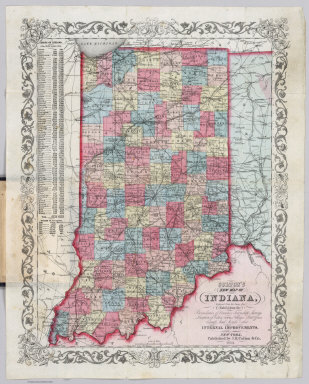
(Covers to) Colton's New Map Of Indiana. Reduced from his Large Map Exhibiting the Boundaries of Counties, Township Surveys, Location of Cities, Towns, Villages, Post Offices, Canals, Rail Roads & other Internal Improvements. New-York, Published by J.H. Colton & Co. 1854. Entered ... 1854, by J.H. Colton ... New York.
Publisher
J.H. Colton & Co.
Author
Colton, J. H.
Full Title
Colton's New Map Of Indiana. Reduced from his Large Map Exhibiting the Boundaries of Counties, Township Surveys, Location of Cities, Towns, Villages, Post Offices, Canals, Rail Roads & other Internal Improvements. New-York, Published by J.H. Colton & Co. 1854. Entered ... 1854, by J.H. Colton ... New York.
Publisher
J.H. Colton & Co.
Author
Lange, Henry, 1821-1893.
Full Title
Indiana und Ohio. H. Lange's Atlas v. Nord Amerika Blatt IX. Braunschweig: Verlag v. George Westermann. Lith. Anst. von L. Kraatz in Berlin.
Publisher
George Westermann.
Author
[Bartholomew, John, Black, Adam & Charles]
Full Title
Ohio, Indiana & Illinois. Published by A. & C. Black. Edinburgh. Printed in Colours by Schenck & Macfariane. Edinburgh. Drawn & Engraved by J. Bartholomew, Edinburgh.
Publisher
A. & C. Black
1-4 of 4
|