|   
                     
                     1876


                     Res. and brewery of Paul Reising ... New


                     State Atlas


                     Res. and brewery of Paul Reising ... New
                     
                    | 
      
        |   
                     
                     1876


                     Map of Pike County (with) Plan of Peters


                     State Atlas


                     Map of Pike County. (with) Plan of Peter
                     
                    | 
      
        |   
                     
                     1876


                     Map of Gibson County.


                     State Atlas


                     Map of Gibson County. (Published by Bask
                     
                    | 
      
        |   
                     
                     1876


                     Plan of Mount Vernon, Posey County (with


                     State Atlas


                     Plan of Mount Vernon, Posey County. (wit
                     
                    | 
      
        |   
                     
                     1876


                     Map of Posey County.


                     State Atlas


                     Map of Posey County. (Published by Baski
                     
                    | 
      
        |   
                     
                     1876


                     St. Lawrence Catholic Church and School,


                     State Atlas


                     St. Lawrence Catholic Church and School,
                     
                    | 
      
        |   
                     
                     1876


                     Map of Vanderburgh County.


                     State Atlas


                     Map of Vanderburgh County. (Published by
                     
                    | 
      
        |   
                     
                     1876


                     Plan of Evansville, Vanderburgh Co.


                     State Atlas


                     Plan of Evansville, Vanderburgh Co. (Pub
                     
                    | 
      
        |   
                     
                     1876


                     Map of Floyd County.


                     State Atlas


                     Map of Floyd County. (Published by Baski
                     
                    | 
      
        |   
                     
                     1876


                     Plan of the City of New Albany, Floyd Co


                     State Atlas


                     Plan of the City of New Albany, Floyd Co
                     
                    | 
      
        |   
                     
                     1876


                     Map of Crawford County.


                     State Atlas


                     Map of Crawford County. (Published by Ba
                     
                    | 
      
        |   
                     
                     1876


                     Map of Warrick County.


                     State Atlas


                     Map of Warrick County. (Published by Bas
                     
                    | 
      
        |   
                     
                     1876


                     Map of Spencer County.


                     State Atlas


                     Map of Spencer County. (Published by Bas
                     
                    | 
      
        |   
                     
                     1876


                     Residence of the late Dr. Seth Hobbs ...


                     State Atlas


                     Residence of the late Dr. Seth Hobbs ...
                     
                    | 
      
        |   
                     
                     1876


                     Map of Perry County.


                     State Atlas


                     Map of Perry County. (Published by Baski
                     
                    | 
      
        |   
                     
                     1876


                     Map of Dubois County.


                     State Atlas


                     Map of Dubois County. (Published by Bask
                     
                    | 
      
        |   
                     
                     1876


                     Map of Harrison County.


                     State Atlas


                     Map of Harrison County. (Published by Ba
                     
                    | 
      
        |   
                     
                     1876


                     Residence and mill of Samuel Cade, Wabas


                     State Atlas


                     Residence and mill of Samuel Cade, Wabas
                     
                    | 
      
        |   
                     
                     1876


                     Plan of Newburgh, Warrick Co. (with) Boo


                     State Atlas


                     Plan of Newburgh, Warrick Co. (with) Pla
                     
                    | 
      
        |   
                     
                     1876


                     Plan of Green Castle, Putnam Co. (with) 


                     State Atlas


                     Plan of Green Castle, Putnam Co. (with) 
                     
                    | 
      
        |   
                     
                     1934


                     Index: Indiana, Railway Distance Maps


                     Guide Book


                     (Index to) Leahy's Hotel Guide and Railw
                     
                    | 
      
        |   
                     
                     1934


                     Railway Distance Map of the State of Ind


                     Guide Book


                     Leahy's Hotel Guide and Railway Distance
                     
                    | 
      
        |   
                     
                     1934


                     Index: (Continues) Indiana, Railway Dist


                     Guide Book


                     (Index to) Leahy's Hotel Guide and Railw
                     
                    | 
      
        |   
                     
                     1934


                     (Continues) Railway Distance Map of the 


                     Guide Book


                     Leahy's Hotel Guide and Railway Distance
                     
                    | 
      
        |   
                     
                     1826


                     Map of the States Of Ohio Indiana & Illi


                     National Atlas


                     Map of the States Of Ohio Indiana & Illi
                     
                    | 
      
        |   
                     
                     1838


                     Indiana.


                     National Atlas


                     Indiana. Entered ... 1838, by T.G. Bradf
                     
                    | 
      
        |   
                     
                     1906


                     Illinois, Indiana, Ohio, Kentucky.


                     World Atlas


                     Illinois, Indiana, Ohio, Kentucky.
                     
                    | 
      
        |   
                     
                     1823


                     Ohio and Indiana.


                     World Atlas


                     Ohio and Indiana By H.S. Tanner. Engrave
                     
                    | 
      
        |   
                     
                     1886


                     J.T. Barker's Railroad and Township Map 


                     County Atlas


                     J.T. Barker's Railroad and Township Map 
                     
                    | 
      
        |   
                     
                     1878


                     (Map 7 - Iowa, Indiana, Illinois, Michig


                     Case Map


                     (Map 7 - Iowa, Indiana, Illinois, Michig
                     
                    | 
      
        |   
                     
                     1849


                     New Map of Indiana with its Roads & Dist


                     World Atlas


                     A New Map of Indiana with its Roads & Di
                     
                    | 
      
        |   
                     
                     1876


                     Geological map of Indiana. Climatologica


                     State Atlas


                     Geological map of Indiana. Climatologica
                     
                    | 
      
        |   
                     
                     1876


                     Congressional districts. Judicial distri


                     State Atlas


                     Congressional districts. Judicial distri
                     
                    | 
      
        |   
                     
                     1876


                     Senatorial districts. Representative dis


                     State Atlas


                     Senatorial districts. Representative dis
                     
                    | 
      
        |   
                     
                     1876


                     Richmond Agricultural Works, Richmond, I


                     State Atlas


                     Richmond Agricultural Works, Richmond, I
                     
                    | 
      
        |   
                     
                     1876


                     New sectional and township map of Indian


                     State Atlas


                     New sectional and township map of Indian
                     
                    | 
      
        |   
                     
                     1876


                     Earlham College, Richmond, Ind. (with re


                     State Atlas


                     Earlham College, Richmond, Ind. (with) R
                     
                    | 
      
        |   
                     
                     1876


                     Map of Steuben County (Indiana)


                     State Atlas


                     Map of Steuben County (Indiana. Publishe
                     
                    | 
      
        |   
                     
                     1876


                     Town of Angola (with) Fremont, Pleasant 


                     State Atlas


                     Town of Angola, Steuben Co., Ind. (with)
                     
                    | 
      
        |   
                     
                     1876


                     Map of Lagrange County (with) La Grange,


                     State Atlas


                     Map of Lagrange County. (with) La Grange
                     
                    | 
      
        |   
                     
                     1876


                     Map of Elkhart County.


                     State Atlas


                     Map of Elkhart County. (Published by Bas
                     
                    | 
      
        |   
                     
                     1899


                     Indiana.


                     County Atlas


                     Indiana. Copyright, 1899, by Geo. F. Cra
                     
                    | 
      
        |   
                     
                     1876


                     "Oak Grove Farm" residence of George Neb


                     State Atlas


                     "Oak Grove Farm" residence of George Neb
                     
                    | 
      
        |   
                     
                     1876


                     Town of Elkhart, Elkhart Co. (with) Gosh


                     State Atlas


                     Town of Elkhart, Elkhart Co. (with) Gosh
                     
                    | 
      
        |   
                     
                     1876


                     Map of St. Joseph County.


                     State Atlas


                     Map of St. Joseph County. (Published by 
                     
                    | 
      
        |   
                     
                     1876


                     Map of La Porte County.


                     State Atlas


                     Map of La Porte County. (Published by Ba
                     
                    | 
      
        |   
                     
                     1876


                     Plan of South Bend (with) Mishawaka, Bre


                     State Atlas


                     Plan of South Bend, St. Joseph Co. (with
                     
                    | 
      
        |   
                     
                     1876


                     Northern Indiana Normal School buildings


                     State Atlas


                     Northern Indiana Normal School buildings
                     
                    | 
      
        |   
                     
                     1876


                     Map of Porter County (with) Chesterton, 


                     State Atlas


                     Map of Porter County. (with) Corporate t
                     
                    | 
      
        |   
                     
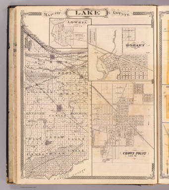
                     1876


                     Map of Lake County (with) Lowell, Hobart


                     State Atlas


                     Map of Lake County. (with) Lowell ... (w
                     
                    |