Browse All

1968 Southeast Asia -- Physical-Political Wall Map Southeast Asia. |

1865 Asiatic Archipelago. World Atlas Asiatic Archipelago. |

1850 Ost-Indien Mit Den Inseln. (East Indies) … World Atlas No. XLVIII. Stieler's Hand-Atlas (No. 44 … |

1850 Ost-Indien Mit Den Inseln. (East Indies) … World Atlas No. XLVIII. Stieler's Hand-Atlas (No. 44 … |

1808 East India Isles. World Atlas East India Isles. |

1806 The Islands of the East Indies with the … World Atlas The Islands of the East Indies with the … |

1806 The Islands of the East Indies with the … World Atlas The Islands of the East Indies with the … |
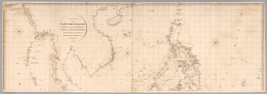
1812 Top sheet: Chart of the East India Islan … Chart Map (Top sheet of) Chart of the East India I … |

1812 Bottom sheet: Chart of the East India Is … Chart Map (Bottom sheet of) Chart of the East Indi … |

1812 Composite: Chart of the East India Islan … Chart Map (Composite of) Chart of the East India I … |

1967 Map Title Page: 131-132. Indochina. 133. … World Atlas (Map Title Page) 131-132. Indochina. 133 … |

1967 Indonesia, Thailand and Malaya. Pergamon … World Atlas Indonesia, Thailand and Malaya. Pergamon … |

1818 Islands of the East Indies. World Atlas The Islands of the East Indies with the … |