Who What Where WhenREMOVEWHERE
|
Author
Ireland. Ordnance Survey.
Full Title
(Covers to) Sheet 11.
Publisher
Ordnance Survey of Ireland
Author
Ireland. Ordnance Survey.
Full Title
Sheet 11.
Publisher
Ordnance Survey of Ireland
Author
Ireland. Ordnance Survey.
Full Title
(Covers to) Sheet 12.
Publisher
Ordnance Survey of Ireland
Author
Ireland. Ordnance Survey.
Full Title
Sheet 12.
Publisher
Ordnance Survey of Ireland
Author
Ireland. Ordnance Survey.
Full Title
(Covers to) Sheet 13.
Publisher
Ordnance Survey of Ireland
Author
Ireland. Ordnance Survey.
Full Title
Sheet 13.
Publisher
Ordnance Survey of Ireland
Author
Ireland. Ordnance Survey.
Full Title
(Covers to) Sheet 14.
Publisher
Ordnance Survey of Ireland
Author
Ireland. Ordnance Survey.
Full Title
Sheet 14.
Publisher
Ordnance Survey of Ireland
Author
Ireland. Ordnance Survey.
Full Title
(Covers to) Sheet 15.
Publisher
Ordnance Survey of Ireland
Author
Ireland. Ordnance Survey.
Full Title
Sheet 15.
Publisher
Ordnance Survey of Ireland
Author
Ireland. Ordnance Survey.
Full Title
(Covers to) Sheet 16.
Publisher
Ordnance Survey of Ireland
Author
Ireland. Ordnance Survey.
Full Title
Sheet 16.
Publisher
Ordnance Survey of Ireland
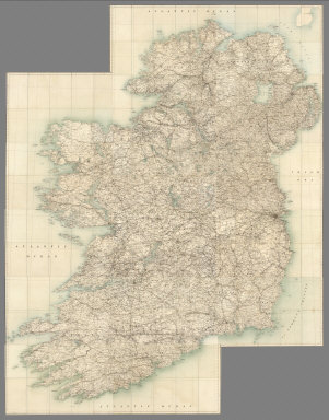
Author
Ireland. Ordnance Survey.
Full Title
(Composite) Sheets 1-16.
Publisher
Ordnance Survey of Ireland
Author
Faden, William, 1750?-1836
Full Title
A map of Ireland divided into provinces and counties, shewing the great and cross roads with the distances of the principal towns from Dublin. By Willm. Faden, Geographer to His Majesty and to HRH the Prince of Wales. London, 1798. Pubd. by W. Faden, Charing Cross, Septr. 17, 1798.
Publisher
William Faden
Author
[Stieler, Adolf, Petermann, A.]
Full Title
Stieler's Hand-Atlas ... No. 15a. Die Britischen Inseln und das Umliegende Meer. (insets) London. Crystall Palast. Helgoland. Rockall (View).
Publisher
Justus Perthes
Author
[Stieler, Adolf, Petermann, A.]
Full Title
Stieler's Hand-Atlas ... No. 15d. Ireland. (insets) Dublin und Dublin Bay. Die See'n von Killarney.
Publisher
Justus Perthes
Author
Stieler, Adolf
Full Title
England, Schottland und Ireland; entw. u. gez. v. Ad. Stieler 1816. gest v. L. Hess. (on upper right margin) Hand Atl. No. 15. (to accompany) Hand-Atlas uber alle Theile der Erde, nach dem neuesten Zustande und uber das Weltgebaude. (insets) Umgebungen von London; Haf. v. Edinburgh; Hafen von Portsmouth.
Publisher
Justus Perthes
Author
Stieler, Adolf
Full Title
Jreland: nach A. St's Angabe, entw. U. gez. von H. Hubbe. 1824. (on upper right margin) Hand Atl. No. 15d. (to accompany) Hand-Atlas uber alle Theile der Erde, nach dem neuesten Zustande und uber das Weltgebaude.
Publisher
Justus Perthes
Author
Stieler, Adolf
Full Title
Die Britischen Jnseln England, Schotland, Jreland. entw. v. Ad. St. 1816. verbessert v. neu gestochen 1823. Hasse sc. Weimar. Amerk, Hierzu 3. Special karten von England, Schotland u. Ireland, No. 15b, 15c, 15d. auf welchen man auch die Namen der ausgezeichneten Berge findet. (on upper right margin) Stielers Hand-Atlas No. 15. (to accompany) Hand-Atlas uber alle Theile der Erde, nach dem neuesten Zustande und uber das Weltgebaude. (insets) Umgebungen von London (no.1) ; Hafen von Portsmouth (no.2) ; Haf. v. Edinburgh (no.3).
Publisher
Justus Perthes
Author
Stieler, Adolf
Full Title
(Composite of) England, Schotland, Ireland
Publisher
Justus Perthes
Author
Melish, John
Full Title
I: (Untitled outline map of Ireland).
Publisher
(John Melish)
Author
[Stieler, Adolf, Petermann, A.]
Full Title
Stieler's Hand-Atlas No. 48. Ireland. (inlet) Dublin und Dublin Bay. Die See'n von Killarney.
Publisher
Justus Perthus
Author
[Stieler, Adolf, Petermann, A.]
Full Title
(Composite of) Stieler's Hand-Atlas No. 46, 47, 48. Grossbritannien, Ireland.
Publisher
Justus Perthus
Author
Stieler, Adolf
Full Title
Die Britischen Inseln Und Das Umliegende Meer. Im Maassstabe Von 1:3.700.000. Von A. Petermann. Gestochen v. Poppey u. Stichart. Gotha: Justus Perthes. 1875.
Publisher
Justus Perthes
Author
Stieler, Adolf
Full Title
Ireland Im Maassstabe Von 1:1.500.000. Von A. Petermann. Poppey u. Jungmann. sculp. Gotha: Justus Perthes. 1872.
Publisher
Justus Perthes
Author
Carey, Mathew
Full Title
A Map of Ireland According to the best Authorities. Engraved for Plowden's Historical Review of the State of Ireland.
Publisher
M. Carey
Author
[Stieler, Adolf, Stulpnagel, F.v.]
Full Title
No. XVII. Stieler's Hand-Atlas (No. 15a.) Die Brittischen Inseln und Die Nord-See.
Publisher
Justus Perthes
Author
[Stieler, Adolf, Stulpnagel, F.v.]
Full Title
No. XX. Stieler's Hand-Atlas (No. 15d.) Ireland.
Publisher
Justus Perthes
Author
[Carey, Henry Charles, Lea, Isaac]
Full Title
Ireland. (to accompany) The Juvenile Atlas or a Series Of Maps, To Illustrate the Old and New Worlds ...1822.
Publisher
H.C. Carey & I. Lea
Author
Bartholomew, J. G.
Full Title
British Isles, Comparative Value of Land, Comparative Density of Population
Publisher
George Newnes, Limited
Author
Bartholomew, J. G.
Full Title
British Isles - Industrial. Agricultural. Iron Industries. Textiles. Glass, Earthenware. &c. (Statistical Diagram) Occupations in the British Isles, 1901.
Publisher
George Newnes, Limited
Author
Johnston, A. Keith
Full Title
The Mountains, Table Lands, Plains & Valleys of the British Isles.
Publisher
William Blackwood & Sons
Author
Kirkwood, Robert
Full Title
United Kingdoms of Great Britain and Ireland.
Publisher
[Robert Kirkwood, John Smith & Son]
Author
Kirkwood, Robert
Full Title
Ireland.
Publisher
[Robert Kirkwood, John Smith & Son]
Author
Wilkinson, Robert
Full Title
Britain, or the United Kingdom of England, Scotland, & Ireland.
Publisher
Robert Wilkinson
Author
Wilkinson, Robert
Full Title
Ireland as Represented in the Imperial Parliament.
Publisher
Robert Wilkinson
Author
Wilkinson, Robert
Full Title
A New Map of Great Britain and Ireland.
Publisher
R. Wilkerson
Author
Wilkinson, Robert
Full Title
Ireland as Represented in the Imperial Parliament.
Publisher
R. Wilkerson
Author
Stieler, Adolf
Full Title
No. XVII. Stielers Hand-Atlas (No. 15). Die Brittischen Inseln, England, Schotland, Ireland.
Publisher
Justus Perthus
Author
[Stieler, Adolf, Stulpnagel, F.v.]
Full Title
(Composite of) No. XVII, XIX, XX. Stieler's Hand-Atlas (No. 15b, 15c, 15d.) England und Wales, Schotland, Ireland.
Publisher
Justus Perthes
Author
Bevan, G. Phillips
Full Title
Ireland to Illustrate the Religious Condition of the People by G. Phillips Bevan, F.S.S., F.G.S., 1881.
Publisher
W. &. A.K. Johnston
Author
Bevan, G. Phillips
Full Title
Ireland to Illustrate the Educational Condition of the People by G. Phillips Bevan, F.S.S., F.G.S., 1881.
Publisher
W. &. A.K. Johnston
Author
Bevan, G. Phillips
Full Title
Ireland to Illustrate the Industrial Condition of the People by G. Phillips Bevan, F.S.S., F.G.S., 1881.
Publisher
W. &. A.K. Johnston
Author
Bevan, G. Phillips
Full Title
Ireland to Illustrate the Criminal Condition of the People by G. Phillips Bevan, F.S.S., F.G.S., 1881.
Publisher
W. &. A.K. Johnston
Author
Bevan, G. Phillips
Full Title
Ireland to Illustrate the Pauperism of the People, by G. Phillips Bevan, F.S.S., F.G.S., 1881.
Publisher
W. &. A.K. Johnston
Author
Bevan, G. Phillips
Full Title
Ireland to Illustrate the Marine Commercial Position of the Country by G. Phillips Bevan, F.S.S., F.G.S., 1881.
Publisher
W. &. A.K. Johnston
Author
Bevan, G. Phillips
Full Title
Ireland to Illustrate the Agricultural Condition of the Country by G. Phillips Bevan, F.S.S., F.G.S., 1881.
Publisher
W. &. A.K. Johnston
Author
Bevan, G. Phillips
Full Title
Ireland to Illustrate the Military Condition of the Country by G. Phillips Bevan, F.S.S., F.G.S., 1881.
Publisher
W. &. A.K. Johnston
|