Browse All

1847 Texas. School Atlas Map of the state of Texas. Engraved to i … |

1929 142. Colo., Kans. World Atlas Stati Uniti, United States of America, C … |

1929 Legend: 142-44. Colo., Kans., N.M., Okla … World Atlas (Legend to) Stati Uniti, United States o … |

1890 Kansas, Nebraska. World Atlas County & township map of the states of K … |

1870 Kan., Neb., Colo. [State Atlas, World Atlas] Map of Kansas, Nebraska and Colorado. Sh … |

1880 Kansas, Nebraska. World Atlas County & township map of the states of K … |

1966 Streams. Stream Piracy. Kaaterskill, N.Y … Physical Atlas Streams. Stream Piracy. Kaaterskill, N.Y … |

1859 A New Map of Kansas. World Atlas A New Map of Kansas by W.H. Holmes. Publ … |

1859 Nebraska, Kansas, New Mexico, and Indian … World Atlas A New Map of Nebraska, Kansas, New Mexic … |

1940 Road map of Kansas National Atlas Rand McNally Road map, Kansas. Copyright … |

1890 (Birdseye view Great Plains) Timetable Map (Birdseye view of the Great Plains). Kni … |

1890 Cover: World's pictorial line. Timetable Map (Covers to) World's pictorial line. Bird … |

1890 Text Page: World's pictorial line. Timetable Map (Text Page to) World's pictorial line. B … |

1885 Kansas National Atlas Kansas. (to accompany) Bradstreet's Pock … |

1867 Covers: New Map Of Kansas And The Gold M … Pocket Map (Covers to) Gunn & Mitchell's New Map Of … |

1883 Kansas. World Atlas Kansas. |

1936 Pictorial Map of Kansas. Separate Map (Pictorial Map of Kansas). |

1873 Kansas. World Atlas Gray's Atlas Map of Kansas. |

1881 Kansas. National Atlas Gray's New Map of Kansas by Frank A. Gra … |

1878 Kansas. National Atlas Cram's Rail Road & Township Map of Kansa … |
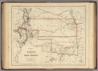
1857 Territory of Kansas And Indian Territory … National Atlas Territory of Kansas And Indian Territory … |

1891 Map of Kansas. 65 World Atlas Map of Kansas. Copyright 1891 by Matthew … |
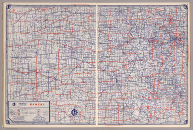
1939 Rand McNally Road map: Kansas National Atlas Rand McNally Road map: Kansas. Copyright … |

1869 Covers: New Rail-Road & Township Map Of … Pocket Map (Covers to) New Rail Road & township map … |

1869 New Rail Road & township map of Missouri … Pocket Map New Rail Road & township map of Missouri … |

1935 Kansas. National Atlas Kansas. |

1889 Territory of Wyoming, Alabama, Louisiana … National Atlas Territory of Wyoming, Alabama, Louisiana … |

1967 206-207. United States of America, South … World Atlas 206-207. United States of America, South … |

1865 Kansas, and Nebraska and Indian Territor … World Atlas Colton's Map of Kansas, Nebraska, Dakota … |

1869 Kansas. World Atlas Colton's Kansas. Published By G. W & C. … |

1852 Nebraska, Kansas, Iowa, Missouri. National Atlas (Nebraska, Kansas, Iowa, Missouri). |

1948 Kansas. World Atlas Kansas. 5366. |

1865 Missouri And Kansas. World Atlas Johnson's Missouri And Kansas By Johnson … |

1865 Nebraska, Dakota, Idaho, and Montana. World Atlas Johnson's Nebraska, Dakota, Idaho, and M … |

1924 Text Page: Industrial Statistics of the … National Atlas (Text Page) Industrial Statistics of the … |

1924 AutoTrails Map, Iowa, Eastern Nebraska, … National Atlas Commercial Atlas of America. Rand McNall … |

1924 Kansas. National Atlas Commercial Atlas of America. Rand McNall … |

1924 Text Page: Kansas - Geographical Feature … National Atlas (Text Page) Kansas - Counties, Creeks, R … |

1924 AutoTrails Map, Southern Nebraska, Easte … National Atlas Commercial Atlas of America. Rand McNall … |

1924 Text Page: Kansas - Geographical Feature … National Atlas (Text Page) Kansas - Counties, Creeks, R … |

1924 Kansas. National Atlas Commercial Atlas of America. Rand McNall … |

1884 Kansas, Nebraska. World Atlas County & township map of the states of K … |

1857 Nebraska And Kansas. National Atlas Nebraska and Kansas. No. 50. Published b … |

1859 Nebraska, Kansas, New Mexico, and Indian … World Atlas A New Map of Nebraska, Kansas, New Mexic … |

1903 Text Page: Oklahoma. Kansas. National Atlas (Text Page) Rand, McNally Co.'s Oklahoma … |

1903 Text Page: Kansas. National Atlas (Text Page) Rand, McNally Co.'s Kansas. |

1903 Text Page: Kansas. National Atlas (Text Page) Rand, McNally Co.'s Kansas. |

1903 Kansas. National Atlas Rand, McNally & Co.'s Kansas. |

1886 Kansas, Nebraska. World Atlas County & township map of the states of K … |

1889 Text Page: Louisiana. Kansas. National Atlas (Text Page) Louisiana. Kansas. |