Browse All

1796 Province of Maine. National Atlas The Province of Maine, From the best Aut … |

1856 Maine. World Atlas Maine. Published by J.H. Colton & Co. 17 … |

1776 The Provinces of Massachusetts Bay and N … National Atlas A Map of the most Inhabited part of New … |

1823 Maine. [Manuscript Map, National Atlas] Maine. |

1823 (Description of) Maine. [Manuscript Map, National Atlas] (Description of) Maine. |

1867 Schonberg's Map of Maine and New Brunswi … National Atlas Schonberg's Map of Maine and New Brunswi … |

1956 Shell Highway Map of Maine. National Atlas Shell Map of Maine and Maritime Province … |

1956 Various Regions and Cities in and around … National Atlas Quebec. Portland. Regional map of Maine, … |

1889 Maine. World Atlas Railroad and County Map of Maine. Geo. F … |

1886 Maine. World Atlas Colton's Maine. Published by G. W & C. B … |

1832 Lower-Canada, N.B., N.Y., Vt., Maine. World Atlas North America sheet II. Lower-Canada and … |

1874 Maine. World Atlas Colton's Maine. Published by G. W & C. B … |

1866 Maine. World Atlas Colton's Maine. Published by G.W. & C.B. … |

1874 Maine, N.B. National Atlas Asher & Adams' Maine and New Brunswick w … |

1865 Maine. Vermont and New Hampshire. World Atlas Maine. Vermont and New Hampshire. |

1901 Maine. World Atlas Maine. |

1834 Covers: Maine New Hampshire And Vermont Pocket Map (Covers to) Map of Maine New Hampshire A … |

1834 Maine New Hampshire And Vermont Pocket Map Map of Maine New Hampshire And Vermont, … |

1847 Covers: Maine, New Hampshire, Vermont, M … Pocket Map (Covers to) Map Of The States Of Maine, … |

1847 Map of the States of Maine, New Hampshir … Pocket Map Map Of The States Of Maine, New Hampshir … |

1838 Covers: Map Of Maine, New Hampshire And … Pocket Map (Covers to) Map Of Maine, New Hampshire … |

1838 Map Of Maine, New Hampshire And Vermont Pocket Map Map Of Maine, New Hampshire And Vermont … |

1827 Covers: Maine, New Hampshire and Vermont Pocket Map (Covers to) Map of Maine, New Hampshire … |

1827 Maine, New Hampshire and Vermont Pocket Map Map of Maine, New Hampshire and Vermont, … |

1855 Covers: Maine. 1855 Pocket Map (Covers to) Maine. 1855. Published By J. … |

1855 Maine. 1855 Pocket Map Maine. 1855. Published By J.H. Colton. N … |

1926 Covers: Maine. Liberty Auto Road Map 192 … Pocket Map (Covers to) Rand McNally Special Auto Ro … |

1926 Maine. Liberty Auto Road Map 1926 Pocket Map Rand McNally Special Auto Road Map Maine … |

1827 Maine Pocket Map Maine. (Pocket Atlas Of The New England … |

1828 Covers: Maine Pocket Map (Covers to) Maine. Published by A. Finle … |

1828 Maine Pocket Map Maine. Published by A. Finley, Philada. … |

1859 Maine, New Hampshire, Vermont Separate Map Maine, New Hampshire, Vermont 1859. Publ … |

1859 Maine Separate Map Maine 1859. Published By A.J. Coolidge, … |

1859 New Hampshire Separate Map New Hampshire 1859. Published By A.J. Co … |

1853 A New Map of the Maine World Atlas A New Map of the Maine. Published by Tho … |

1874 County Map of Maine. National Atlas County Map of the State of Maine. (inset … |

1864 Maine World Atlas Johnson's Maine By Johnson and Ward. |

1855 A new map of Maine World Atlas A new map of Maine. Published by Thomas, … |

1873 Maine, New Hampshire, Vermont, Massachus … World Atlas Map of Maine, New Hampshire, Vermont, Ma … |

1953 Maine. World Atlas Maine. U.S. State. |

1875 Text Page: Maine School Atlas (Text Page to) Maine. (to accompany) A H … |
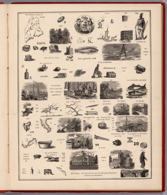
1875 View: Hieroglyphic View of Maine School Atlas (View to) Maine. (to accompany) A Hierog … |

1875 Text Page: Maine School Atlas (Text Page to) Maine. (to accompany) A H … |

1816 Maine World Atlas Maine. Engraved by A. Doolittle, New Hav … |

1845 Maine. National Atlas Maine. (By Sidney E. Morse and Samuel Br … |

1873 State of Maine. County Atlas Map of the State of Maine. Drawn and Eng … |

1837 Maine. [National Atlas, School Atlas] (Maine). |

1870 Maine. World Atlas Johnson's Maine. Entered ... 1866. |

1845 Maine. World Atlas Neueste Karte von Maine. Nach den besste … |

1871 Maine. County Atlas Map of the State of Maine. Drawn and Eng … |