|
|
REFINE
Browse All : Images of Maryland and Delaware from 1862
1-3 of 3
Author
Colton, J. H.
Full Title
(Covers to) Colton's New Topographical Map of The States Of Virginia, Maryland and Delaware, Showing Also Eastern Tennessee & Parts Of Other Adjoining States, All the Fortifications, Military Stations, Rail Roads, Common Roads and other Internal Improvements Compiled from the Latest & most Authentic Sources, On A Scale of 12 Miles to the Inch. Published By J.H. Colton, No. 172 William St. New York. Entered ... 1862, by J.H. Colton ... New York. Printed by Lang & Laing Lith 117 Fulton St. New York.
Publisher
J.H. Colton
Author
Colton, J. H.
Full Title
Colton's New Topographical Map of The States Of Virginia, Maryland and Delaware, Showing Also Eastern Tennessee & Parts Of Other Adjoining States, All the Fortifications, Military Stations, Rail Roads, Common Roads and other Internal Improvements Compiled from the Latest & most Authentic Sources, On A Scale of 12 Miles to the Inch. Published By J.H. Colton, No. 172 William St. New York. Entered ... 1862, by J.H. Colton ... New York. Printed by Lang & Laing Lith 117 Fulton St. New York.
Publisher
J.H. Colton
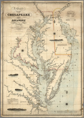
Author
Lucas, Fielding Jr.
Full Title
A Chart of the Chesapeake And Delaware Bays Compiled And Published By Fielding Lucas Junr. Baltimore. Corrected_1862. Engraved by John and William W. Warr Philadelphia. Sold by Lucas Brothers. Drawn by F. Lucas Jr. Entered ... 1852 by Fielding Lucas Jr. ... Maryland.
Publisher
Fielding, Lucas Jr.
1-3 of 3
|