Who What Where WhenREMOVE |
REFINE
Browse All : Images of Massachusetts and New Hampshire
1-25 of 25
Author
Jefferys, Thomas
Full Title
A Map of the most Inhabited part of New England, containing the Provinces of Massachusetts Bay and New Hampshire, with the Colonies of Conecticut And Rhode Island, Divided into Counties and Townships: The Whole composed from Actual Surveys and its Situation adjusted by Astronomical Observations. (with) A Plan of the Town of Boston. November 29th 1774. Published according to Act by Thos. Jefferys Geographer to His Royal highness the Prince of Wales near Charing Cross. (Northern section)
Publisher
Sayer and Bennett
Author
Johnson, A.J.
Full Title
Johnson's Vermont, New Hampshire, Massachusetts, Rhode Island, and Connecticut. Published by Johnson and Ward. Entered ... 1864, by A.J. Johnson ... New York.
Publisher
Johnson and Ward
Author
[Jones, C.H., Hamilton, T.H., Williams, J.David]
Full Title
Map of Maine, New Hampshire, Vermont, Massachusetts, Rhode Island, and Connecticut.
Publisher
J. David Williams
Author
[Geological Survey (U.S.), Massachusetts. Topographical Survey Commission]
Full Title
Massachusetts-New Hampshire. Haverhill sheet. Preliminary edition subject to corrections. U.S. Geological Survey, J.W. Powell, Director. State of Massachusetts ... commissioners. Henry Gannett, Chief Geographer. Marcus Baker, geographer in charge. Triangulation by the U.S. Coast and Geodetic Survey. Topography by John D. Hoffmann, E.W.F. Natter and W.H. Lovell. Surveyed in 1884-6-8. Forbes Co., Boston & N.Y. (1890)
Publisher
Topographical Survey Commission
Author
[Geological Survey (U.S.), Massachusetts. Topographical Survey Commission]
Full Title
Massachusetts-New Hampshire. Newburyport sheet. Preliminary edition subject to corrections. U.S. Geological Survey, J.W. Powell, Director. State of Massachusetts ... commissioners. Henry Gannett, Chief Geographer. Marcus Baker, geographer in charge. Triangulation by the U.S. Coast and Geodetic and Borden surveys. Coast line by U.S. Coast and Geodetic Survey. Topography by J.D. Hoffman (i.e. Hoffmann) and W.H. Lovell. Surveyed in 1884-8. Forbes Co., Boston & N.Y. (1890)
Publisher
Topographical Survey Commission
Author
Tanner, Henry S.
Full Title
Map of the States of Maine, New Hampshire, Vermont, Massachusetts, Connecticut, & Rhode Island. By H.S. Tanner. American Atlas. Engraved and Published by H.S. Tanner, Philadelphia. Entered according to Act of Congress, 14th Day of Novr. 1820, by H.S. Tanner, of the State of Pennsylvania.
Publisher
Henry Tanner
Author
Asher & Adams
Full Title
Asher & Adams' New Hampshire, Vermont, Massachusetts, Rhode Island, and Connecticut. Entered according to Act of Congress 1874 by Asher & Adams in the Office of the Librarian of Congress at Washington.
Publisher
Asher & Adams.
Author
Marshall, John
Full Title
Carte des Provinces Septles. des Etats-Unis. (1807)
Publisher
Dentu, Imprimeur-Libraire.
Author
W. & A.K. Johnston Limited
Full Title
Vermont, New Hampshire, Massachusetts, Rhode Island, & Connecticut.
Publisher
W. & A.K. Johnston Limited
Author
Kenyon Company
Full Title
(Covers to) Map of New England ... Copyright 1920 The Kenyon Company, Inc., Map Makers Des Moines, Iowa. Principal Automobile Highways Shown Thus ... (inset) Eastern Portion Of Massachusetts. (on verso) Index of New England States, With Official 1920 Census...
Publisher
The Kenyon Company, Inc.
Author
Kenyon Company
Full Title
(Text page to) Map of New England ... Copyright 1920 The Kenyon Company, Inc., Map Makers Des Moines, Iowa. Principal Automobile Highways Shown Thus ... (inset) Eastern Portion Of Massachusetts. (on verso) Index of New England States, With Official 1920 Census...
Publisher
The Kenyon Company, Inc.
Author
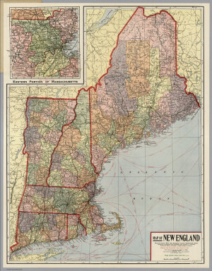
Kenyon Company
Full Title
Map of New England ... Copyright 1920 The Kenyon Company, Inc., Map Makers Des Moines, Iowa. Principal Automobile Highways Shown Thus ... (inset) Eastern Portion Of Massachusetts. (on verso) Index of New England States, With Official 1920 Census...
Publisher
The Kenyon Company, Inc.
Author
[Bowen, Emanuel, Gibson, John]
Full Title
New England. (to accompany) Atlas Minimus or a New Set of Pocket Maps of the Several Empires, Kingdoms and States of the Known World, with Historical Extracts relative to each. Drawn and Engraved by J. Gibson from the Best Authorities, Revis'd, Corrected and Improv'd by Eman: Bowen Geographer to His Majesty.
Publisher
J. Newberry
Author
Hillebrands, A.J.
Full Title
Atlas de Vereenigde Staten No. 2. Maine, New Hampshire, Vermont, Massachusetts en Connecticut.
Publisher
[J. Oomkens, J. Zoon]
Author
[Geological Survey (U.S.), Massachusetts. Topographical Survey Commission]
Full Title
Massachusetts-New Hampshire-Vermont. Warwick sheet. Preliminary edition subject to corrections. U.S. Geological Survey, J.W. Powell, Director. State of Massachusetts ... commissioners. Henry Gannett, Chief Geographer. Marcus Baker, geographer in charge. Triangulation by the U.S. Coast and Geodetic and Borden surveys. Topography by R.D. Cummin and Laurence Thompson under direction of W.D. Johnson. Surveyed in 1887. Forbes Co., Boston & N.Y. (1890)
Publisher
Topographical Survey Commission
Author
[Geological Survey (U.S.), Massachusetts. Topographical Survey Commission]
Full Title
Massachusetts-New Hampshire. Fitchburg sheet. Preliminary edition subject to corrections. U.S. Geological Survey, J.W. Powell, Director. State of Massachusetts ... commissioners. Henry Gannett, Chief Geographer. Marcus Baker, geographer in charge. Triangulation by the U.S. Coast and Geodetic and Borden surveys. Topography by E.W.F. Natter. Surveyed in 1887. Forbes Co., Boston & N.Y. (1890)
Publisher
Topographical Survey Commission
Author
[Geological Survey (U.S.), Massachusetts. Topographical Survey Commission]
Full Title
Massachusetts-New Hampshire. Groton sheet. Preliminary edition subject to corrections. U.S. Geological Survey, J.W. Powell, Director. State of Massachusetts ... commissioners. Henry Gannett, Chief Geographer. Marcus Baker, geographer in charge. Triangulation by R.U. Goode. Topography by E.W.F. Natter, J.H. Jennings and W. Kramer. Surveyed in 1887. Forbes Co., Boston & N.Y. (1890)
Publisher
Topographical Survey Commission
Author
Cram, George Franklin
Full Title
Cram's Rail Road & County Map of New England.
Publisher
George F. Cram
Author
[Geological Survey (U.S.), Massachusetts. Topographical Survey Commission]
Full Title
Massachusetts-New Hampshire. Lowell sheet. Preliminary edition subject to corrections. U.S. Geological Survey, J.W. Powell, Director. State of Massachusetts ... commissioners. Henry Gannett, Chief Geographer. Marcus Baker, geographer in charge. Triangulation by the U.S. Coast and Geodetic and Borden surveys. Topography by E.W.F. Natter. Surveyed in 1886. Forbes Co., Boston & N.Y. (1890)
Publisher
Topographical Survey Commission
Author
[Geological Survey (U.S.), Massachusetts. Topographical Survey Commission]
Full Title
Massachusetts-New Hampshire. Winchendon sheet. Preliminary edition subject to corrections. U.S. Geological Survey, J.W. Powell, Director. State of Massachusetts ... commissioners. Henry Gannett, Chief Geographer. Marcus Baker, geographer in charge. Triangulation by R.U. Goode. Topography by W.D. Johnson. Surveyed in 1887. Forbes Co., Boston & N.Y. (1890)
Publisher
Topographical Survey Commission
Author
USSR (Union of Soviet Socialist Republics).
Full Title
199. New England. The World Atlas.
Publisher
USSR
Author
Johnson, A.J.
Full Title
Johnson's Vermont, New Hampshire, Massachusetts, Rhode Island, and Connecticut.
Publisher
Johnson and Ward
Author
Marbut, Curtis F.
Full Title
Soil Map of the United States by Curtis F. Marbut and Associates in the Soil Survery, U.S. Department of Agriculture, F.J. Marschner, Cartographer and Associate in Compilation. 1931. Soils, Plate 5, Section 1. Lith. A. Hoen & Co., Inc. Atlas of American Agriculture.
Publisher
U.S. Department of Agriculture
Author
[Bartholomew, John, Black, Adam & Charles]
Full Title
New York, Vermont, New Hampshire, Rhode Island, Massachusetts & Connecticut. Published by A. & C. Black. Edinburgh. Printed in Colours by Schenck & Macfariane. Edinburgh. Drawn & Engraved by J. Bartholomew, Edinburgh.
Publisher
A. & C. Black
Author
[Black, Adam & Charles, Hall, Sidney, Hughes, William]
Full Title
New York, Vermont, New Hampshire, Rhode Island, Massachusetts & Connecticut. Edinburgh, Published by A. &. C. Black. Drawn and Engraved by J. Bartholomew, Edinburgh
Publisher
Adam & Charles Black
1-25 of 25
|