Who What Where WhenREMOVE |
REFINE
Browse All : Images of Massachusetts and U.S. North East
1-11 of 11
Author
Finley, Anthony
Full Title
Massachusetts. (Pocket Atlas Of The New England States And New York). (with 7 maps) Connecticut, New York. Maine. New Hampshire. Vermont. Massachusetts. Rhode Island. Published by A. Finley Philada. Young & Delleker Sc.
Publisher
Anthony Finley
Author
[Heermans, Anna A., Cogswell, Charlotte B.]
Full Title
(Text Page to) Massachusetts. (to accompany) A Hieroglyphic Geography Of The United States. Part 1 Containing The States Of Maine, New Hampshire, Vermont, Massachusetts, Rhode Island, Connecticut And New York. Designed And Drawn By Anna A. Heermans. Engraved By Charlotte B. Cogswell, Cooper Union Engraving School, New York. New York, E.P. Dutton And Company, 713 Broadway, 1875. (on verso) Entered ... 1874, by Charlotte B. Cogswell ... Washington. Riverside, Cambridge: Electrotyped And Printed By H.O. Houghton And Company.
Publisher
E.P. Dutton & Co.
Author
[Heermans, Anna A., Cogswell, Charlotte B.]
Full Title
(View to) Massachusetts. (to accompany) A Hieroglyphic Geography Of The United States. Part 1 Containing The States Of Maine, New Hampshire, Vermont, Massachusetts, Rhode Island, Connecticut And New York. Designed And Drawn By Anna A. Heermans. Engraved By Charlotte B. Cogswell, Cooper Union Engraving School, New York. New York, E.P. Dutton And Company, 713 Broadway, 1875. (on verso) Entered ... 1874, by Charlotte B. Cogswell ... Washington. Riverside, Cambridge: Electrotyped And Printed By H.O. Houghton And Company.
Publisher
E.P. Dutton & Co.
Author
[Heermans, Anna A., Cogswell, Charlotte B.]
Full Title
(Text Page to) Massachusetts. (to accompany) A Hieroglyphic Geography Of The United States. Part 1 Containing The States Of Maine, New Hampshire, Vermont, Massachusetts, Rhode Island, Connecticut And New York. Designed And Drawn By Anna A. Heermans. Engraved By Charlotte B. Cogswell, Cooper Union Engraving School, New York. New York, E.P. Dutton And Company, 713 Broadway, 1875. (on verso) Entered ... 1874, by Charlotte B. Cogswell ... Washington. Riverside, Cambridge: Electrotyped And Printed By H.O. Houghton And Company.
Publisher
E.P. Dutton & Co.
Author
[Gray, Ormando Willis, Lloyd, H.H., Walling, H. F.]
Full Title
Atlas of the United States. New England and New York. (Published by Stedman, Brown & Lyon, Cincinnati. 1872. Entered ... 1872, by H.F. Walling, and O.W. Gray, and H.H. Lloyd & Co. ... Washington)
Publisher
Stedman, Brown & Lyon
Author
Kenyon Company
Full Title
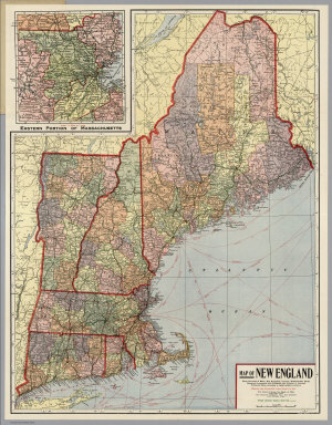
(Covers to) Map of New England ... Copyright 1920 The Kenyon Company, Inc., Map Makers Des Moines, Iowa. Principal Automobile Highways Shown Thus ... (inset) Eastern Portion Of Massachusetts. (on verso) Index of New England States, With Official 1920 Census...
Publisher
The Kenyon Company, Inc.
Author
Kenyon Company
Full Title
(Text page to) Map of New England ... Copyright 1920 The Kenyon Company, Inc., Map Makers Des Moines, Iowa. Principal Automobile Highways Shown Thus ... (inset) Eastern Portion Of Massachusetts. (on verso) Index of New England States, With Official 1920 Census...
Publisher
The Kenyon Company, Inc.
Author
Kenyon Company
Full Title
Map of New England ... Copyright 1920 The Kenyon Company, Inc., Map Makers Des Moines, Iowa. Principal Automobile Highways Shown Thus ... (inset) Eastern Portion Of Massachusetts. (on verso) Index of New England States, With Official 1920 Census...
Publisher
The Kenyon Company, Inc.
Author
[Blunt, Edmund M. (Edmund March), 1770-1862, Des Barres, Joseph F. W. (Joseph Frederick Wallet), 1722-1824, Taber, W. C., Wadsworth, A. S. (Alex. S.)]
Full Title
(The north eastern coast of North America from New York to Cape Canso including Sable Island by Edmund Blunt. West sheet. (with) Buzzards Bay drawn from the survey of Des Barres and information furnished by W.C. Taber ... (with) Boston Harbour from the survey of A.S. Wadsworth, U.S.N. and the chart of Des Barres. Published & Sold by E. & G.W. Blunt, No. 154 Water Street, corner of Maiden Lane, New York. G. Ely Sct. Engd. by D.R. Harrison. Entered ... 22nd day of July 1828, by Edmund Blunt of the State of New York)
Publisher
E. & G.W. Blunt.
Author
Lloyd, H.H.
Full Title
Atlas of the United States. New England and New York. (by H.H. Lloyd. Published by Stedman, Brown & Lyon, Baltimore. 1873)
Publisher
Stedman, Brown & Lyon
Author
Touring club italiano
Full Title
(Legend to) Stati Uniti, United States of America, Massachusetts, Connecticut, Rhode Island, New Jersey, Delaware, Maryland, con parte di Pennsylvania, New York, Vermont, New Hampshire. Propr. Artistico-letteraria del T.C.I. Ufficio cartografico del T.C.I. (1929)
Publisher
Touring club italiano
1-11 of 11
|