Who What Where WhenREMOVE |
REFINE
Browse All : Images of Massachusetts and Vermont
1-22 of 22
Author
Johnson, A.J.
Full Title
Johnson's Vermont, New Hampshire, Massachusetts, Rhode Island, and Connecticut. Published by Johnson and Ward. Entered ... 1864, by A.J. Johnson ... New York.
Publisher
Johnson and Ward
Author
[Jones, C.H., Hamilton, T.H., Williams, J.David]
Full Title
Map of Maine, New Hampshire, Vermont, Massachusetts, Rhode Island, and Connecticut.
Publisher
J. David Williams
Author
Tanner, Henry S.
Full Title
Map of the States of Maine, New Hampshire, Vermont, Massachusetts, Connecticut, & Rhode Island. By H.S. Tanner. American Atlas. Engraved and Published by H.S. Tanner, Philadelphia. Entered according to Act of Congress, 14th Day of Novr. 1820, by H.S. Tanner, of the State of Pennsylvania.
Publisher
Henry Tanner
Author
Asher & Adams
Full Title
Asher & Adams' New Hampshire, Vermont, Massachusetts, Rhode Island, and Connecticut. Entered according to Act of Congress 1874 by Asher & Adams in the Office of the Librarian of Congress at Washington.
Publisher
Asher & Adams.
Author
W. & A.K. Johnston Limited
Full Title
Vermont, New Hampshire, Massachusetts, Rhode Island, & Connecticut.
Publisher
W. & A.K. Johnston Limited
Author
Jocelyn, N. & S.S.
Full Title
(Covers to) Map Exhibiting the Farmington, & Hampshire & Hampden Canals, Together with the Line of their proposed continuation through the Valley of the Connecticut River, to Canada. Engraved and published by N. & S.S. Jocelyn. New Haven, 1828. Entered ... August 1st 1828 by N. & S.S. Jocelyn ... Connt. (inset) Profile of the Canals. Surveys furnished by Davis Hurd Esqr. Chief Engineer.
Publisher
N. & S.S. Jocelyn
Author
Jocelyn, N. & S.S.
Full Title
Map Exhibiting the Farmington, & Hampshire & Hampden Canals, Together with the Line of their proposed continuation through the Valley of the Connecticut River, to Canada. Engraved and published by N. & S.S. Jocelyn. New Haven, 1828. Entered ... August 1st 1828 by N. & S.S. Jocelyn ... Connt. (inset) Profile of the Canals. Surveys furnished by Davis Hurd Esqr. Chief Engineer.
Publisher
N. & S.S. Jocelyn
Author
Kenyon Company
Full Title
(Covers to) Map of New England ... Copyright 1920 The Kenyon Company, Inc., Map Makers Des Moines, Iowa. Principal Automobile Highways Shown Thus ... (inset) Eastern Portion Of Massachusetts. (on verso) Index of New England States, With Official 1920 Census...
Publisher
The Kenyon Company, Inc.
Author
Kenyon Company
Full Title
(Text page to) Map of New England ... Copyright 1920 The Kenyon Company, Inc., Map Makers Des Moines, Iowa. Principal Automobile Highways Shown Thus ... (inset) Eastern Portion Of Massachusetts. (on verso) Index of New England States, With Official 1920 Census...
Publisher
The Kenyon Company, Inc.
Author
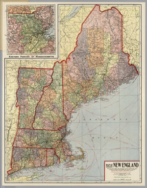
Kenyon Company
Full Title
Map of New England ... Copyright 1920 The Kenyon Company, Inc., Map Makers Des Moines, Iowa. Principal Automobile Highways Shown Thus ... (inset) Eastern Portion Of Massachusetts. (on verso) Index of New England States, With Official 1920 Census...
Publisher
The Kenyon Company, Inc.
Author
Hillebrands, A.J.
Full Title
Atlas de Vereenigde Staten No. 2. Maine, New Hampshire, Vermont, Massachusetts en Connecticut.
Publisher
[J. Oomkens, J. Zoon]
Author
[Geological Survey (U.S.), Massachusetts. Topographical Survey Commission]
Full Title
Massachusetts-Vermont. Hawley sheet. Preliminary edition subject to corrections. U.S. Geological Survey, J.W. Powell, Director. State of Massachusetts ... commissioners. Henry Gannett, Chief Geographer. Marcus Baker, geographer in charge. Triangulation by Borden Survey. Topography by H.L. Smyth, W.H. Lovell and G.H. Page under direction of W.D. Johnson. Surveyed in 1886. Forbes Co., Boston & N.Y. (1890)
Publisher
Topographical Survey Commission
Author
[Geological Survey (U.S.), Massachusetts. Topographical Survey Commission]
Full Title
Massachusetts. Greenfield sheet. Preliminary edition subject to corrections. U.S. Geological Survey, J.W. Powell, Director. State of Massachusetts ... commissioners. Henry Gannett, Chief Geographer. Marcus Baker, geographer in charge. Triangulation by the U.S. Coast and Geodetic and Borden surveys. Topography by W.H. Lovell under direction of W.D. Johnson and by Anton Karl. Surveyed in 1886 and 1887. Forbes Co., Boston & N.Y. (1890)
Publisher
Topographical Survey Commission
Author
[Geological Survey (U.S.), Massachusetts. Topographical Survey Commission]
Full Title
Massachusetts-New Hampshire-Vermont. Warwick sheet. Preliminary edition subject to corrections. U.S. Geological Survey, J.W. Powell, Director. State of Massachusetts ... commissioners. Henry Gannett, Chief Geographer. Marcus Baker, geographer in charge. Triangulation by the U.S. Coast and Geodetic and Borden surveys. Topography by R.D. Cummin and Laurence Thompson under direction of W.D. Johnson. Surveyed in 1887. Forbes Co., Boston & N.Y. (1890)
Publisher
Topographical Survey Commission
Author
Cram, George Franklin
Full Title
Cram's Rail Road & County Map of New England.
Publisher
George F. Cram
Author
Arbuckle Bros.
Full Title
Massachusetts, Vermont, Kentucky, New Jersey. Copyright 1889 Arbuckle Bros. N.Y.
Publisher
Arbuckle Bros.
Author
[Nicholson, W. L., United States. Post Office Dept.]
Full Title
Post Route Map Of The State Of New York And Parts Of Vermont, Massachusetts, Connecticut, New Jersey And Pennsylvania, Showing Also The Adjacent Portions Of The Dominion Of Canada. Designed And Constructed Under The Orders Of Postmaster General Alex. W. Randall And Second Asst. Postmaster General Geo. Wm. McLellan By W.L. Nicholson, Topographer Of P.O. Dept. 1868. Drawn by Paul Goepel. Engraved by D. McClelland, Washn. D.C. (seal) Post Office Department United States Of America "With Celerity, Certainty And Security." (inset) Prov. Of Ontario. (inset) Postal Service Of Long Island With The Principal Mail Connections Of The City Of New York.
Publisher
U.S. Post Office
Author
USSR (Union of Soviet Socialist Republics).
Full Title
199. New England. The World Atlas.
Publisher
USSR
Author
Johnson, A.J.
Full Title
Johnson's Vermont, New Hampshire, Massachusetts, Rhode Island, and Connecticut.
Publisher
Johnson and Ward
Author
Marbut, Curtis F.
Full Title
Soil Map of the United States by Curtis F. Marbut and Associates in the Soil Survery, U.S. Department of Agriculture, F.J. Marschner, Cartographer and Associate in Compilation. 1931. Soils, Plate 5, Section 1. Lith. A. Hoen & Co., Inc. Atlas of American Agriculture.
Publisher
U.S. Department of Agriculture
Author
Rand McNally and Company
Full Title
(Text Page) Vermont - Counties, Creeks, Islands, Lakes, Mountains, Rivers, and Towns. Massachusetts - Counties, Islands, Lakes, Mountains, Rivers, and Towns.
Publisher
Rand McNally and Company
1-22 of 22
|