|
|
REFINE
Browse All : Images of Mediterranean Sea
1-31 of 31
Author
Johnson, A.J.
Full Title
Johnson's Roman Empire, Imperium Romanorum Latissime Patens By Johnson And Ward. (insets): No. 104 Graecia. No. 105 Italia.
Publisher
Johnson and Ward
Author
[Bayer, Herbert, Container Corporation of America]
Full Title
Mediterranean. Turkey. (insets) (Vicinity of Gibralter and Vallette).
Publisher
Container Corporation of America
Author
San Francisco Newspaper Maps
Full Title
Map of Iraq; Map of the Suez Canal; Map of Europe; Map of Australia; Map of Malta; (on reverse) Map of the Western Mediterranean; Map of Turkey.
Publisher
San Francisco Examiner and other Newspapers
Author
San Francisco Newspaper Maps
Full Title
Map of the Western Mediterranean; Map of Turkey. (on verso) Map of Iraq; Map of the Suez Canal; Map of Europe; Map of Australia; Map of Malta.
Publisher
San Francisco Examiner and other Newspapers
Author
Roux, Joseph
Full Title
(Covers to) Carte De La Mer Mediterranee en Douze Fueilles. Dediee a Mgr. Le Duc De Choiseul Colonel General des Suisses et Grisons Ministre de la Guerre et de la Marine, Par son tres humble Serviteur Joseph Roux Hydrographe du Roy, sur le Port a St. Jean, a Marseille, Avec Privilege du Roy. 1764.
Publisher
J. Roux.
Author
Roux, Joseph
Full Title
(Title Page to) Carte De La Mer Mediterranee en Douze Fueilles. Dediee a Mgr. Le Duc De Choiseul Colonel General des Suisses et Grisons Ministre de la Guerre et de la Marine, Par son tres humble Serviteur Joseph Roux Hydrographe du Roy, sur le Port a St. Jean, a Marseille, Avec Privilege du Roy. 1764. Premiere Feuille.
Publisher
J. Roux.
Author
Roux, Joseph
Full Title
IIe. Fueille. Avec Privilege du Roy a Marseille, Chez Joseph Roux Hydrographe du Roy, sur le Port a St. Jean. 1764.
Publisher
J. Roux.
Author
Roux, Joseph
Full Title
IVe. Fueille. Avec Privilege du Roy a Marseille, Chez Joseph Roux Hydrographe du Roy, sur le Port a St. Jean. 1764.
Publisher
J. Roux.
Author
Roux, Joseph
Full Title
V. Fueille. Avec Privilege du Roy a Marseille, Chez Joseph Roux Hydrographe du Roy, sur le Port a St. Jean. 1764.
Publisher
J. Roux.
Author
Roux, Joseph
Full Title
IIIe. Fueille. Avec Privilege du Roy a Marseille, Chez Joseph Roux Hydrographe du Roy, sur le Port a St. Jean. 1764.
Publisher
J. Roux.
Author
Roux, Joseph
Full Title
VI. Fueille. Avec Privilege du Roy a Marseille, Chez Joseph Roux Hydrographe du Roy, sur le Port a St. Jean. (1764)
Publisher
J. Roux.
Author
Roux, Joseph
Full Title
VII. Fueille. Avec Privilege du Roy a Marseille, Chez Joseph Roux Hydrographe du Roy, sur le Port a St. Jean. (1764)
Publisher
J. Roux.
Author
Roux, Joseph
Full Title
VIII. Fueille. Avec Privilege du Roy a Marseille, Chez Joseph Roux Hydrographe du Roy, sur le Port a St. Jean. (1764)
Publisher
J. Roux.
Author
Roux, Joseph
Full Title
IX. Fueille. Avec Privilege du Roy a Marseille, Chez Joseph Roux Hydrographe du Roy, sur le Port a St. Jean. (1764)
Publisher
J. Roux.
Author
Roux, Joseph
Full Title
X. Fueille. Avec Privilege du Roy a Marseille, Chez Joseph Roux Hydrographe du Roy, sur le Port a St. Jean. (1764)
Publisher
J. Roux.
Author
Roux, Joseph
Full Title
XII. Fueille. Avec Privilege du Roy a Marseille, Chez Joseph Roux Hydrographe du Roy, sur le Port a St. Jean. (1764)
Publisher
J. Roux.
Author
Roux, Joseph
Full Title
XI. Fueille. Avec Privilege du Roy a Marseille, Chez Joseph Roux Hydrographe du Roy, sur le Port a St. Jean. (1764)
Publisher
J. Roux.
Author
Kitchin, Thomas
Full Title
(Europe divided into its empires, kingdoms, states, republics, &c. Southern States. By Thos. Kitchin, Hydrographer to the King, with many additions and improvements from the latest surveys and observations. London, published by Robt. Sayer, Fleet Street, as the Act directs, Jany. 1st, 1787).
Publisher
Robert Sayer
Author
Bellin, Jacques Nicolas, 1703-1772
Full Title
Plan de la Ville Fort et Port d'Alger.
Publisher
J.N. Bellin
Author
Bellin, Jacques Nicolas, 1703-1772
Full Title
Plan de l'isle de Tabarque à la coste de Barbarie.
Publisher
J.N. Bellin
Author
Bellin, Jacques Nicolas, 1703-1772
Full Title
Plan de port Farine.
Publisher
J.N. Bellin
Author
Bellin, Jacques Nicolas, 1703-1772
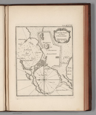
Full Title
Plan des Ports et Ville d'Alexandrie.
Publisher
J.N. Bellin
Author
Bellin, Jacques Nicolas, 1703-1772
Full Title
Carte reduite de la Mer Mediterranee.
Publisher
J.N. Bellin
Author
Thomson, John
Full Title
Chart of the Mediterranean Sea. (with) Bay & roads of Marseilles. (with) The harbour of Genoa. (with) Plan of the rock and bay of Gibraltar shewing the position of the combined fleet and attack of the battering ships in 1782. (with) Leghorn Road. (with) Sketch of the watering place of Algeziras. (with) Attack on Algiers by the fleet under the command of Adml. Lord Exmouth, Augst. 27th 1816. (with) Gulf of Smyrna. Neele sculp., Strand. Drawn & engraved for Thomson's New general atlas, 1817.
Publisher
[Baldwin, Cradock, and Joy, John Cumming, John Thomson]
Author
Stieler, Adolf
Full Title
No. XLIV. Stieler's Hand-Atlas (No. 42a). Das Mittellaendische und Schwarze Meer. Auch als General Karte des Osmanischen Reichs. (insets) Die Canarischen Inseln Mit Madeira. Nil Delta.
Publisher
Justus Perthes
Author
Stieler, Adolf
Full Title
No. XLIV. Stieler's Hand-Atlas (No. 42a). Das Mittellaendische und Schwarze Meer. Auch als General Karte des Osmanischen Reichs. (insets) Die Canarischen Inseln Mit Madeira. Nil Delta.
Publisher
Justus Perthes
Author
[Delarochette, Louis Stanislas d'Arcy, Faden, William, 1750?-1836]
Full Title
A chart of the coasts of Spain and Portugal, with the Balearic Islands, and part of the coast of Barbary. By L.S. De la Rochette. MDCCLXXX. 2d. edition. London: engraved & published as the Act directs, by Wm. Faden, successr. to the late T. Jefferys, Geogr. to the King. Charing Cross, June 28th, 1780.
Publisher
William Faden
Author
Bradford, Thomas G.
Full Title
Mediterranean Sea. (to accompany) A Comprehensive Atlas, Geographical, Historical & Commercial. By T.G. Bradford. William D. Ticknor, Boston. Wiley & Long, New-York. Entered ... 1835, by Thos. G. Bradford ... Massachusetts.
Publisher
[William D. Ticknor, Wiley & Long]
Author
USSR (Union of Soviet Socialist Republics).
Full Title
101. Mediterranean Sea. The World Atlas.
Publisher
USSR
Author
Polish Army Topography Service
Full Title
Mediterranean Sea. (inset) Barcelona. (inset) El Iskandariya (Alexandria). Pergamon World Atlas. Pergamon Press, Ltd. & P.W.N. Poland 1967. Sluzba Topograficzna W.P.
Publisher
Pergamon Press
1-31 of 31
|