|
REFINE
Browse All : Images of Mexico from 1847
1-15 of 15
Author
[Bruff, J. Goldsborough, Disturnell, John]
Full Title
(Covers to) A Correct Map Of The Seat Of War In Mexico. Being a Copy of Genl. Arista's Map, taken at Resaca de la Palma, with additions and Corrections ... New York: Published By J. Disturnell. 102, Broadway, 1847. Designed by J.G. Bruff Washington D.C. Entered ... 1847, by J.G. Bruff ... New York. Lith. of E. Jones & G.W. Newman, 128, Fulton St. On Stone by J. Probst. (with 4 inset maps).
Publisher
J. Disturnell
Author
[Bruff, J. Goldsborough, Disturnell, John]
Full Title
A Correct Map Of The Seat Of War In Mexico. Being a Copy of Genl. Arista's Map, taken at Resaca de la Palma, with additions and Corrections ... New York: Published By J. Disturnell. 102, Broadway, 1847. Designed by J.G. Bruff Washington D.C. Entered ... 1847, by J.G. Bruff ... New York. Lith. of E. Jones & G.W. Newman, 128, Fulton St. On Stone by J. Probst. (with 4 inset maps).
Publisher
J. Disturnell
Author
Tanner, Henry S.
Full Title
A Map Of The United States Of Mexico, As organized and defined by the several Acts of the Congress of that Republic. Constructed from a great variety of Printed and Manuscript Documents by H.S. Tanner. Fifth edition, 1847. Published by H.S. Tanner. Entered ... 1846, by H.S. Tanner ... New York. (inset) Map Of The Roads &c. From Vera Cruz & Alvarado To Mexico. (inset) Harbor Of Vera Cruz.
Publisher
H.S. Tanner
Author
Tanner, Henry S.
Full Title
(Covers to) A Map Of The United States Of Mexico, As organized and defined by the several Acts of the Congress of that Republic. Constructed from a great variety of Printed and Manuscript Documents by H.S. Tanner. Fifth edition, 1847. Published by H.S. Tanner. Entered ... 1846, by H.S. Tanner ... New York. (inset) Map Of The Roads &c. From Vera Cruz & Alvarado To Mexico. (inset) Harbor Of Vera Cruz.
Publisher
H.S. Tanner
Author
Phelps, Humphrey
Full Title
Ornamental Map Of The United States & Mexico. 1847. Phelps' Ornamental Map Of The United States And Mexico. Entered ... 1846, by Humphrey Phelps ... New York. Published by Phelps, Ensigns & Thayer, 36 Ann Street, New York. Barritt, Sc.
Publisher
H. Phelps
Author
U.S. War Department, Topographical Engineers
Full Title
Siege Of Vera Cruz, by the U.S. Troops under Major General Scott, in March 1847, from Surveys made by Major Turnbull, Captains Hughes, McClellan & Johnston; Lieutenants Derby & Hardcastle, Topl. Engineers. Drawn by Capt. McClellan.
Publisher
No publisher
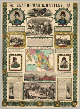
Author
Ensigns & Thayer
Full Title
Seat Of War & Battles. Map of the Seat of War. Entered ... 1847, by Ensigns & Thayer ... New York. Published By Ensigns & Thayer, 50 Ann Street, New York. And 12 Exchange St., Buffalo. Jos. Ward, 52 Cornhill St., Boston. Rufus Blanchard, Cincinnati.
Publisher
[Jos. Ward, Ensigns & Thayer ; Rufus Blanchard]
Author
Disturnell, John
Full Title
(Covers to) Mapa de los Estados Unidos De Mejico, Segun lo organizado y definido por las varias actas del Congreso de dicha Republica ... Lo Publican J. Disturnell, 102 Broadway. Nuevo York. 1847. Revised Edition. (inset) Carto De Los Caminos &c. Desde Vera Cruz Y Alvarado A Mejico. (inset) Chart of the Bay of Vera Cruz. (inset) Map Showing The Battle Grounds of the 8th and 9th May 1846.
Publisher
J. Disturnell
Author
Disturnell, John
Full Title
Mapa de los Estados Unidos De Mejico, Segun lo organizado y definido por las varias actas del Congreso de dicha Republica ... Lo Publican J. Disturnell, 102 Broadway. Nuevo York. 1847. Revised Edition. (inset) Carto De Los Caminos &c. Desde Vera Cruz Y Alvarado A Mejico. (inset) Chart of the Bay of Vera Cruz. (inset) Map Showing The Battle Grounds of the 8th and 9th May 1846.
Publisher
J. Disturnell
Author
Mitchell, Samuel Augustus
Full Title
Map of the United States. Engraved to illustrate Mitchell's school and family geography. (with) Map of Mexico and Guatimala engraved to illustrate Mitchell's school and family geography. Engraved by W. Williams. Entered ... 1839 by S. Augustus Mitchell ... Connecticut.
Publisher
Thomas, Cowperthwait & Co.
Author
Mitchell, Samuel Augustus
Full Title
Map Of Mexico, Including Yucatan & Upper California, exhibiting The Chief Cities and Towns, The Principal Travelling Routes &c. Philadelphia: Published by S. Augustus Mitchell N.E. Corner Of Market And Seventh Sts. 1847. Entered ... 1846 by S. Augustus Mitchell ... Pennsylvania. (inset) The Late Battlefield.
Publisher
S.A. Mitchell
Author
[Mitchell, Samuel Augustus, Stealey, Geo.]
Full Title
(Covers to) Map Of Mexico, Including Yucatan & Upper California, exhibiting The Chief Cities and Towns, The Principal Travelling Routes &c. Philadelphia: Published by S. Augustus Mitchell N.E. Corner Of Market And Seventh Sts. 1847. Entered ... 1847 by S. Augustus Mitchell ... Pennsylvania. (inset) The Late Battlefield. (with) Map of the Principal Roads from Vera Cruz and Alvarado to the City of Mexico ... Compiled from the latest and best Authorities. By Geo. Stealey, Civil Engineer.
Publisher
S.A. Mitchell
Author
[Mitchell, Samuel Augustus, Stealey, Geo.]
Full Title
Map Of Mexico, Including Yucatan & Upper California, exhibiting The Chief Cities and Towns, The Principal Travelling Routes &c. Philadelphia: Published by S. Augustus Mitchell N.E. Corner Of Market And Seventh Sts. 1847. Entered ... 1847 by S. Augustus Mitchell ... Pennsylvania. (inset) The Late Battlefield. (with) Map of the Principal Roads from Vera Cruz and Alvarado to the City of Mexico ... Compiled from the latest and best Authorities. By Geo. Stealey, Civil Engineer.
Publisher
S.A. Mitchell
Author
[Bruff, J. Goldsborough, Disturnell, John]
Full Title
Map Of The Valley Of Mexico and the Surrounding Mountains. New York, Published by J.Disturnell, No. 102 Broadway, 1847. Miller's Lith. 102 Broadway, N.Y. Entered ... 1847, by John Disturnell ... New York. (inset) Map of the Route between Vera Cruz, Alvarado & Puebla. (inset) Profile Of The Route Between Mexico And Vera Cruz.
Publisher
J. Disturnell
Author
[Barnard, J.G., Bruff, J.]
Full Title
Sketch from the mouth of the Coatzacoalcos River to the town of Mina-Titlan ; made by order of Commodore M.C. Perry. Comdg. Home Squadron. 1847. By Lieuts. Alden, Blunt & May. (inset) View of the entrance of the Coatzacoalcos River. (to accompany) Maps Illustrating The Isthmus of Tehuantepec.
Publisher
D. Appleton & Co.
1-15 of 15
|