Browse All

1899 Mexico Pocket Map Mexico. Rand, McNally & Co.'s Mexico. Ra … |

1881 Covers: Mexico Pocket Map (Covers to) Mexico. Rand, McNally & Co.' … |

1881 Title Page: Mexico Pocket Map (Title Page to) Mexico. Rand, McNally & … |

1881 Mexico Pocket Map Mexico. Rand, McNally & Co.'s Mexico. Co … |

1901 Mexico. World Atlas Map United States of Mexico. |

1839 The Coasts of Guatimala And Mexico, from … Separate Map The Coasts of Guatimala And Mexico, from … |

1873 Topographical map of the United States. State Atlas Topographical map of the United States. … |

1853 Mexico and Guatemala World Atlas Mexico & Guatemala. Published by Thomas, … |

1850 Map of the United States. Separate Map Map Of The United States And Their Terri … |

1944 Latin America World Atlas Latin America. (to accompany) Atlas Of G … |

1846 Texas. World Atlas Texas. Nach den besten Quellen entw. u. … |

1845 Mexico. World Atlas Neueste Karte von Mexico. Nach den beste … |

1846 Cover: Mexico, United States of. Pocket Map (Covers to) A Map Of The United States O … |

1864 Mexico World Atlas Johnson's Mexico By Johnson and Ward. (i … |

1855 Mexico and Guatemala World Atlas Mexico & Guatemala. Published by Thomas, … |

1862 Mexique, Amerique Centrale, les Antilles … World Atlas Etats-Unis du Mexique, Amerique Centrale … |

1892 Cover: California, Texas, Mexico and Ari … Timetable Map (Covers to:) California, Texas, Mexico A … |

1892 California, Texas, Mexico and Arizona So … Timetable Map California, Texas, Mexico And Arizona So … |

1892 Railway, steamship lines, Southern Pacif … Timetable Map Correct map of the railway & steamship l … |

1825 Carta Esferica de las Costas Y Golfo De … Chart Map Carta Esferica de las Costas Y Golfo De … |

1854 Messico e Stati dell'America Centrale; I … World Atlas Messico e Stati dell'America Centrale. ( … |

1817 Mexico World Atlas Mexico. Drawn by A. Arrowsmith. Engraved … |

1847 Ornamental Map Of The United States & Me … Separate Map Ornamental Map Of The United States & Me … |

1846 Ornamental Map Of The United States and … Separate Map Ornamental Map Of The United States & Me … |

1855 Ornamental Map Of The United States & Me … Separate Map Ornamental Map Of The United States & Me … |

1848 Map Of The United States And Mexico Separate Map Ornamental Map Of The United States & Me … |

1847 Siege Of Vera Cruz, by the U.S. Troops Separate Map Siege Of Vera Cruz, by the U.S. Troops u … |

1854 Map Of The United States of America, The … Pocket Map Map Of The United States of America, The … |
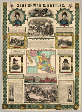
1847 Seat Of War and Battles. Map of the Seat … Separate Map Seat Of War & Battles. Map of the Seat o … |

1849 Map Of Mexico, Texas, Old And New Califo … Separate Map Map Of Mexico, Texas, Old And New Califo … |

1850 Map Of Mexico, Including Yucatan & Upper … Separate Map Map Of Mexico, Including Yucatan & Upper … |

1846 Map Of The Seat Of War Gen. Taylor's Fie … Separate Map Map Of The Seat Of War Gen. Taylor's Fie … |

1849 Map Of The United States The British Pro … Separate Map Map Of The United States The British Pro … |

1870 Carte Generale Des Etats - Unis Et Du Me … Separate Map Carte Generale Des Etats - Unis Et Du Me … |

1876 Carte Generale Des Etats - Unis Et Du Me … Separate Map Carte Generale Des Etats - Unis Et Du Me … |

1957 Index: Mexico and Central America, Plate … World Atlas (Index to) Mexico and Central America. C … |

1957 Mexico and Central America, Plate 113, V … World Atlas Mexico and Central America. The Geograph … |

1824 Mexico and Internal Provinces World Atlas Mexico and Internal Provinces. (Publishe … |

1873 Mexico and Central America Comprising Gu … World Atlas Mexico and Central America (Northern Par … |

1839 Cover: Mexique, partie des Provinces Uni … Case Map (Covers to) Nouvelle Carte du Mexique, E … |

1846 Map of Mexico Showing the Seat of War. Pocket Map Map of Mexico Showing the Seat of War. L … |

1953 Mexico. World Atlas Mexico. (inset) (Vicinity of Mexico City … |

1953 Mexico. Central America. World Atlas Mexico. Central America. |

1828 Mexico, Guatimala. World Atlas Mexico and Guatimala (sic). By Sidney Ha … |

1861 Robinson's Landing, Mouth of Colorado Ri … Exploration Book Robinson's Landing, Mouth of Colorado Ri … |

1861 Cocopas. Exploration Book Cocopas. Colorado Exploring Expedition. … |

1861 Yumas. Exploration Book Yumas. Colorado Exploring Expedition. In … |

1861 Shore of Lower Colorado. Exploration Book Shore of Lower Colorado. Colorado Explor … |

1861 Sections of Alluvial Bank of the Colorad … Exploration Book Fig 3. Sections of Alluvial Bank of the … |

1861 Edge of Sun-cracked Stratum of Clay is A … Exploration Book Fig 5. Edge of Sun-cracked Stratum of Cl … |