Who What Where WhenREMOVEWHAT
|
Author
Rand McNally and Company
Full Title
Mexico. Rand, McNally & Co.'s Mexico. Rand, McNally & Co., Map Publishers and Engravers, Chicago, Ill. ... Copyright, 1898, ... 1891 ... (inset) Map Of The Valley Of Mexico. (with 61 page index) Rand, McNally & Co.'s Indexed Map Of Mexico ... Chicago And New York: Rand, McNally & Co. ... (on verso) Copyright, 1899, by Rand, McNally & Co., Chicago.
Publisher
Rand McNally & Co.
Author
Rand McNally and Company
Full Title
(Covers to) Mexico. Rand, McNally & Co.'s Mexico. Copyright, 1881, by Rand, McNally & Co., Chicago, Ill. ... (with 16 page index) Rand, McNally & Co.'s Indexed Map Of Mexico Showing The Railroads, States And Territories, Lakes and Rivers ... Chicago: Rand, McNally & Co., Map Publishers And Engravers, 148 to 154 Monroe Street. (on verso) Entered ... 1881, by Rand, McNally & Co. ... Washington.
Publisher
Rand McNally & Co.
Author
Rand McNally and Company
Full Title
(Title Page to) Mexico. Rand, McNally & Co.'s Mexico. Copyright, 1881, by Rand, McNally & Co., Chicago, Ill. ... (with 16 page index) Rand, McNally & Co.'s Indexed Map Of Mexico Showing The Railroads, States And Territories, Lakes and Rivers ... Chicago: Rand, McNally & Co., Map Publishers And Engravers, 148 to 154 Monroe Street. (on verso) Entered ... 1881, by Rand, McNally & Co. ... Washington.
Publisher
Rand McNally & Co.
Author
Rand McNally and Company
Full Title
Mexico. Rand, McNally & Co.'s Mexico. Copyright, 1881, by Rand, McNally & Co., Chicago, Ill. ... (with 16 page index) Rand, McNally & Co.'s Indexed Map Of Mexico Showing The Railroads, States And Territories, Lakes and Rivers ... Chicago: Rand, McNally & Co., Map Publishers And Engravers, 148 to 154 Monroe Street. (on verso) Entered ... 1881, by Rand, McNally & Co. ... Washington.
Publisher
Rand McNally & Co.
Author
Cram, George Franklin
Full Title
Map United States of Mexico.
Publisher
George F. Cram
Author
[Arrowsmith, John, Forbes, Alexander]
Full Title
The Coasts of Guatimala And Mexico, from Panama To Cape Mendocino: with the Principal Harbours in California. 1839. London, Smith Elder & Co. 1839. John Arrowsmith. (with 6 inset maps).
Publisher
Smith Elder & Co.
Author
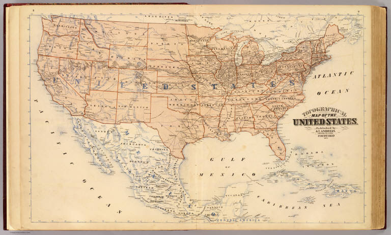
Andreas, A. T. (Alfred Theodore), 1839-1900
Full Title
Topographical map of the United States. Published by A.T. Andreas, Lakeside Building, Chicago, 1873. (Chas. Shober & Co. Proprietors of Chicago Lith. Co.)
Publisher
A.T. Andreas
Author
Mitchell, Samuel Augustus
Full Title
Mexico & Guatemala. Published by Thomas, Cowperthwait & Co. No. 253 Market Street, Philadelphia. Entered ... 1850, by Thomas, Cowperthwait & Co. ... Pennsylvania. (with four inset maps) Valley of Mexico, Guatemala ..., The Isthmus of Tehuantepec ..., Isthmus of Nicaragua ...
Publisher
Thomas, Cowperthwait & Co.
Author
U.S. War Department, Topographical Engineers
Full Title
Map Of The United States And Their Territories Between The Mississippi and the Pacific Ocean And Of Part of Mexico. Compiled in the Bureau of the Corps of Topogl. Engs. under a Resolution of the U.S. Senate. From the best authorities which could be obtained. 1850. Engraved by Sherman and Smith, New-York.
Publisher
Sherman and Smith
Author
Raisz, Erwin
Full Title
Latin America. (to accompany) Atlas Of Global Geography. By Erwin Raisz. Lectures in Cartography, Institute Of Geographical Exploration, Harvard University, Cambridge, Mass. ... Global Press Corporation, Publishers. New York, N.Y. Sole Distributors: Harper & Brothers, New York. (on verso) Copyright 1944, by Global Press Corporation.
Publisher
Global Press Corp.
Author
Radefeld, Carl Christian Franz, 1788-1874
Full Title
Texas. Nach den besten Quellen entw. u. gez. vom Hauptm. Radefeld. 1846. Stich, Druck und Verlag des Bibliographischen Instituts zu Hildburghausen, (1860)
Publisher
Bibliographischen Instituts
Author
Radefeld, Carl Christian Franz, 1788-1874
Full Title
Neueste Karte von Mexico. Nach den besten Quellen entw. u. gezeichn. von Hauptm. Radefeld. 1845. Stich, Druk, und Verlag des Bibliographischen Instituts zu Hildburghausen, (1860)
Publisher
Bibliographischen Instituts
Author
Tanner, Henry S.
Full Title
(Covers to) A Map Of The United States Of Mexico, As organized and defined by the several Acts of the Congress of that Republic. Constructed from a great variety of Printed and Manuscript Documents by H.S. Tanner. Third Edition, 1846. Published by H.S. Tanner. Entered ... 1846, by H.S. Tanner ... New York. (inset) Map Of The Roads &c. From Vera Cruz & Alvarado To Mexico.
Publisher
H.S. Tanner
Author
Johnson, A.J.
Full Title
Johnson's Mexico By Johnson and Ward. (inset) Territory And Isthmus Of Tehuantepec.
Publisher
Johnson and Ward
Author
Mitchell, Samuel Augustus
Full Title
Mexico & Guatemala. Published by Thomas, Cowperthwait & Co., no. 253 Market Street, Philadelphia. Entered ... 1850 by Thomas, Cowperthwait & Co. ... Pennsylvania. (with four inset maps) The Isthmus of Tehuantepec showing Proposed Route from the Gulf of Mexico to the Pacific Ocean, The Isthmus of Nicaragua Showing the Proposed Routes from the Caribbean Sea to the Pacific Ocean, Guatemala or Central America, and the Valley of Mexico.
Publisher
Cowperthwait, Desilver & Butler
Author
Garnier, F. A., 1803-1863
Full Title
Etats-Unis du Mexique, Amerique Centrale, comprenant les Republiques de Guatemala, Honduras, St. Salvador, Nicaragua, Costa-Rica, et les Grandes et Petites Antilles. (with) Isthmes de Panama et de Nicaragua. (with) Isthme de Tehuantepec. (with) Iles Guadeloupe et Marie Galante. (with) Ile Martinique. Atlas spheroidal & universel de geographie dresse par F.A. Garnier, geographe. Paris, Vve. Jules Renouard, Editeur, Rue de Tournon, no. 6. 1860. Sarazin, Imp. r. Git-le-Coeur, 8, Paris.
Publisher
Veuve Jules Renouard, Libraire
Author
Southern Pacific Company
Full Title
(Covers to:) California, Texas, Mexico And Arizona Southern Pacific Co. "Sunset route" from New Orleans to the Pacific Coast ... January, 1892. American Bank Note Co., N.Y.
Publisher
Poole Brothers.
Author
Southern Pacific Company
Full Title
California, Texas, Mexico And Arizona Southern Pacific Co. "Sunset route" from New Orleans to the Pacific Coast ... January, 1892. American Bank Note Co., N.Y.
Publisher
Poole Brothers.
Author
Southern Pacific Company
Full Title
Correct map of the railway & steamship lines operated by the Southern Pacific Company [United States and Mexico]. Poole Bros., Map Engravers, Chicago. (inset) County map of Texas showing the Atlantic System of the Southern Pacific Company. (inset) San Francisco, California. (inset) Los Angeles, California. (inset) New Orleans. (inset) San Antonio, Texas.
Publisher
Poole Brothers.
Author
[Spain, Dirección de Hydrographia, Bauza, Felipe, Mexico Republica]
Full Title
Carta Esferica de las Costas Y Golfo De Californias Llamado Mar De Cortes que Comprende desde et Cabo Corrientes hasta el Puerto de S. Diego Constuida Por les oficiales de la Marina Espanola, y publicado por orn del Exmo Sr. D. Guadalupe Victoria Primer Presidente de la Republica Mexico Ano de 1825. (with 3 inset chart maps).
Publisher
Republica Mexico
Author
[Colton, J. H., Marzolla, Benedetto]
Full Title
Messico e Stati dell'America Centrale. (with) Istmo di Panama indicante le strade pel transito tra Chagres e Panama. La presente Carta e stata eseguita sul quella, pubblicata in 4 fogli de J.H. Colton, Nuova-York 1851 ... Essa fa parte dell'Atlante Geografico che si pubblica da B. Marzolla. Napoli, 1854.
Publisher
B. Marzolla
Author
Arrowsmith, Aaron
Full Title
Mexico. Drawn by A. Arrowsmith. Engraved by Sidy. Hall. Published, 1817, by A. Constable & Co. Edinburgh.
Publisher
[A. Constable & Co., Longman & Compy]
Author
Phelps, Humphrey
Full Title
Ornamental Map Of The United States & Mexico. 1847. Phelps' Ornamental Map Of The United States And Mexico. Entered ... 1846, by Humphrey Phelps ... New York. Published by Phelps, Ensigns & Thayer, 36 Ann Street, New York. Barritt, Sc.
Publisher
H. Phelps
Author
Phelps, Humphrey
Full Title
Ornamental Map Of The United States & Mexico. 1846. Phelps' Ornamental Map Of The United States And Mexico. Entered ... 1846, by Humphrey Phelps ... New York. Published by H. Phelps No. 144 Fulton Street, near Broadway, New York. Barritt, Sc.
Publisher
H. Phelps
Author
Ensign, Bridgman & Fanning
Full Title
Ornamental Map Of The United States & Mexico. Map Of The United States And Mexico. Ensign, Bridgman & Fanning, Publishers, 156 William St. New York. Entered ... 1855, by Ensign, Bridgman & Fanning ... New York.
Publisher
Ensign, Bridgman & Fanning
Author
Ensigns & Thayer
Full Title
Ornamental Map Of The United States & Mexico. Map Of The United States And Mexico Including Oregon, Texas and the Californias. Entered ... 1848, by Ensigns & Thayer ... New York. Published by Ensign & Thayer, 50 Ann Street New York. And 12 Exchange St., Buffalo. Sowle & Ward, 43 Cornhill, Boston. Rufus Blanchard: Cincinatti.
Publisher
[Ensigns & Thayer ; Rufus Blanchard, Sowle & Ward]
Author
U.S. War Department, Topographical Engineers
Full Title
Siege Of Vera Cruz, by the U.S. Troops under Major General Scott, in March 1847, from Surveys made by Major Turnbull, Captains Hughes, McClellan & Johnston; Lieutenants Derby & Hardcastle, Topl. Engineers. Drawn by Capt. McClellan.
Publisher
No publisher
Author
Magnus, Charles
Full Title
Map Of The United States of America, The British Provinces, Mexico, the West Indies and Central America. Published by Charles Magnus. New York. 1854. (inset map) Central America.
Publisher
Charles Magnus
Author
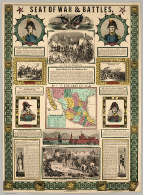
Ensigns & Thayer
Full Title
Seat Of War & Battles. Map of the Seat of War. Entered ... 1847, by Ensigns & Thayer ... New York. Published By Ensigns & Thayer, 50 Ann Street, New York. And 12 Exchange St., Buffalo. Jos. Ward, 52 Cornhill St., Boston. Rufus Blanchard, Cincinnati.
Publisher
[Jos. Ward, Ensigns & Thayer ; Rufus Blanchard]
Author
House & Brown
Full Title
Map Of Mexico, Texas, Old And New California, And Yucatan. Showing the principal Cities and Towns, Travelling Routes &c. Hartford: Published By House & Brown. 1849. Entered ... 1847 by House & Brown ... (inset map) Plan Of Operations At The Battle Of Monterey On The 21st, 22nd, & 23rd Sept. 1846. (inset) Map Of Vera Cruz And San Juan De Ulloa. (Lith. Of E.B.) & E.C. Kellogg, Hartford, Conn.
Publisher
House & Brown
Author
[Mitchell, Samuel Augustus, Dorby & Miller]
Full Title
Map Of Mexico, Including Yucatan & Upper California, exhibiting The Chief Cities And Towns, The Principal Travelling Routes &c. Philadelphia. Published by Dorby & Miller. Auburn, New York. 1850. Entered ... 1847 by S. Augustus Mitchell ... Pennsylva. (inset map) Battle Field Of Monterey.
Publisher
Dorby & Miller
Author
Mitchell, Samuel Augustus
Full Title
Map Of The Seat Of War Gen. Taylor's Field Of Operations In Mexico. Philadelphia. Pubd. by S. Augustus Mitchell, N.E. Corr. of Market & 7th Sts. ... (inset map) The Late Battlefield. (inset) Map of the Seat Of War.
Publisher
S.A. Mitchell
Author
Colton, J.H.
Full Title
Map Of The United States The British Provinces Mexico &c. Showing the Routes of the U.S. Mail Steam Packets to California, and a Plan of the Gold Region. Published By J.H. Colton, 86 Cedar St. New York. 1849. Drawn & Engraved by J.M. Atwood. New York. Entered ... 1849, by J.H. Colton ... New York. (inset) Map Of The Gold Region. California. (untitled inset of South America; From New York to San Francisco via Cape Horn...).
Publisher
J.H. Colton
Author
Andriveau-Goujon, E.
Full Title
Carte Generale Des Etats - Unis Et Du Mexique, Comprenant L'Amerique Centrale Et Les Antilles. E. Andriveau-Goujon, Editeur. Paris, Rue Du Bac, 21. Nouvelle Edition. 1870. (with four inset maps).
Publisher
Andriveau-Goujon
Author
Andriveau-Goujon, E.
Full Title
Carte Generale Des Etats - Unis Et Du Mexique, Comprenant L'Amerique Centrale Et Les Antilles. E. Andriveau-Goujon, Editeur. Paris, Rue Du Bac, 4. Nouvelle Edition. 1876. (with four inset maps).
Publisher
Andriveau-Goujon
Author
Bartholomew, John
Full Title
(Index to) Mexico and Central America. Conic Projection, Standard Parallels 12 (degrees) and 28 (degrees) N. 1:5,500,000.
Publisher
[Houghton Mifflin Co., John Bartholomew & Son LTD.]
Author
Bartholomew, John
Full Title
Mexico and Central America. The Geographical Institute Edinburgh. Edited by John Bartholomew, M.C. LL. D. Copyright - John Bartholomew & Son, LTD. (inset maps) Mexico City, Panama Canal.
Publisher
[Houghton Mifflin Co., John Bartholomew & Son LTD.]
Author
[Thomson, John, Wyld, James, 1790-1836]
Full Title
Mexico and Internal Provinces. (Published by John Thomson & Co. Edinburgh.) (to accompany) A General Atlas, Containing Maps illustrating some important periods in Ancient History; and distinct Maps of the several Empires, Kingdoms and States In The World, From Original Drawings according to the latest Treaties by J. Wyld and Engraved by N.R. Hewitt. Edinburgh, Printed for John Thomson & Co for Baldwin, Cradock & Joy, London & John Cumming, Dublin.
Publisher
John Thomson
Author
[Jones, C.H., Hamilton, T.H., Williams, J.David]
Full Title
Mexico and Central America (Northern Part) Comprising Guatemala, Honduras, San Salvador, and Nicaragua.
Publisher
J. David Williams
Author
Brue, Adrien Hubert, 1786-1832
Full Title
(Covers to) Nouvelle Carte du Mexique, Et D'Une Partie Des Provinces Unies De L'Amerique Centrale. Dediee a l'Academie Royale des Sciences de l Institut de France. Par A.H. Brue, Geographe du Roi, Membre de la common. centrale de la societe de Geographie de Paris, membre-honoraire de celle de Londres, &a. Revue et augmentee par Ch. Picquet, Geographe du Roi et du Due d'Orleans, Proprietaire des Cartes et Atlas de Brue, Quai Conti No. 17, pres de l'Institut. Paris, 1839. Publiee en 1834; Revue en 1837, 1839 ... (with 2 inset maps).
Publisher
Charles Picquet
Author
Sinclair, Thomas
Full Title
Map of Mexico Showing the Seat of War. Lith. of T. Sinclair, 79 So. 3rd St. Philadelphia.
Publisher
Thomas Sinclair
Author
[Bayer, Herbert, Container Corporation of America]
Full Title
Mexico. (inset) (Vicinity of Mexico City).
Publisher
Container Corporation of America
Author
[Bayer, Herbert, Container Corporation of America]
Full Title
Mexico. Central America.
Publisher
Container Corporation of America
Author
Hall, S. (Sidney)
Full Title
Mexico and Guatimala (sic). By Sidney Hall. London, published by Longman, Rees, Orme, Brown & Green, Paternoster Row, March, 1828.
Publisher
Longman, Rees, Orme, Brown and Green
Author
Ives, J.C.
Full Title
Robinson's Landing, Mouth of Colorado River. Colorado Exploring Expedition. General Report - Plate I. J.J. Young from a photograph by Lieut. Ives. Lith. of Sarony, Major & Knapp, 449 Broadway N.Y.
Publisher
U.S.
Author
Ives, J.C.
Full Title
Cocopas. Colorado Exploring Expedition. Indian Portraits, Plate I. B. Mollhausen, Del. Lith. of Sarony, Major & Knapp, 449 Broadway N.Y.
Publisher
U.S.
Author
Ives, J.C.
Full Title
Yumas. Colorado Exploring Expedition. Indian Portraits, Plate II. B. Mollhausen, Del. Lith. of Sarony, Major & Knapp, 449 Broadway N.Y.
Publisher
U.S.
Author
Ives, J.C.
Full Title
Shore of Lower Colorado. Colorado Exploring Expedition. Geology, Plate I. J.J. Young from a sketch by H.B. Mollhausen. Lith. of Sarony, Major & Knapp, 449 Broadway N.Y.
Publisher
U.S.
Author
Ives, J.C.
Full Title
Fig 3. Sections of Alluvial Bank of the Colorado. Fig 4. Cross Stratification formed by Changing Channel.
Publisher
U.S.
|