Who What Where WhenREMOVEWHAT
|
Author
Woodbridge, William C.
Full Title
Political Map Of The United States, Mexico And The British Provinces. Adapted To Woodbridge's Geography. Engraved by J. M. Atwood. N. York. Entered .. . 1845, by W.C. Woodbridge ... Massachusetts. Hartford. Published By Wm. Jas. Hamersley. (inset) Map of Railways & Canals In the Middle States. (inset map) Michigan, Wisconsin, Iowa, Minesota. (Inset map) District Of Columbia.
Publisher
Wm. Jas. Hamersley
Author
Arbuckle Bros.
Full Title
Mexico. Newfoundland. Spain. Sandwich Islands (Hawaii).
Publisher
Arbuckle Bros.
Author
Sinclair, Thomas
Full Title
(Covers to) Map of Mexico Showing the Seat of War. Lith. of T. Sinclair, 79 So. 3rd St. Philadelphia.
Publisher
Thomas Sinclair
Author
Houston And Texas Central Railway
Full Title
Texas and Mexico showing Houston and Texas Central system of railways. Rand, McNally & Co, Engr's, Chicago. (inset) Map of United States and Mexico reduced scale; showing the Houston and Texas Central Railway and connections. (1885)
Publisher
Rand McNally
Author
Brue, Adrien Hubert, 1786-1832
Full Title
Nouvelle Carte du Mexique, Et D'Une Partie Des Provinces Unies De L'Amerique Centrale. Dediee a l'Academie Royale des Sciences de l Institut de France. Par A.H. Brue, Geographe du Roi, Membre de la common. centrale de la societe de Geographie de Paris, membre-honoraire de celle de Londres, &a. Revue et augmentee par Ch. Picquet, Geographe du Roi et du Due d'Orleans, Proprietaire des Cartes et Atlas de Brue, Quai Conti No. 17, pres de l'Institut. Paris, 1839. Publiee en 1834; Revue en 1837, 1839 ... (with 2 inset maps).
Publisher
Charles Picquet
Author
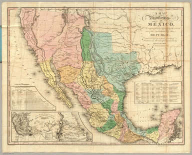
Tanner, Henry S.
Full Title
A Map Of The United States Of Mexico, As organized and defined by the several Acts of the Congress of that Republic. Constructed from a great variety of Printed and Manuscript Documents by H.S. Tanner. Third Edition, 1846. Published by H.S. Tanner. Entered ... 1846, by H.S. Tanner ... New York. (inset) Map Of The Roads &c. From Vera Cruz & Alvarado To Mexico.
Publisher
H.S. Tanner
Author
Woodbridge, William C.
Full Title
Political Map Of The United States, Mexico And The British Provinces. Adapted To Woodbridge's Geography. Engraved by J.M. Atwood. N. York. Entered ... 1845, by W.C. Woodbridge ... Massachusetts. Hartford. Published By Wm. Jas. Hamersley. (to accompany) Modern Atlas, Physical, Political And Statistical; Exhibiting On Separate Maps ... (inset) Map Of Railways & Canals In The Middle States. (inset map) Michigan, Wisconsin, & Iowa. (inset map) District of Columbia.
Publisher
Belknap and Hamersley
Author
Johnson, A.J.
Full Title
Johnson's Mexico. Entered ... 1867. (inset) Isthmus of Tehuantepec. Johnson's Central America. (inset) Isthmus of Panama. Entered ... 1867.
Publisher
A.J. Johnson
Author
Ruhle von Lilienstern, August
Full Title
Nordliches America. Berlin 1824 von R.v.L.
Publisher
C.G. Luderitz
Author
Bartholomew, John
Full Title
(Composite of) Plates 113, 114, Mexico, Central America, West Indies, Vol. 5.
Publisher
[Houghton Mifflin Co., John Bartholomew & Son LTD.]
Author
[Johnston, Alexander Keith, 1804-1871, Rogers, Henry Darwin]
Full Title
Mexico, North-western States. By Prof. H.D. Rogers & A. Keith Johnston, F.R.S.E. Entered in Sta. Hall. London ... & according to an act of Congress ... 1857, by H.D. Rogers ... Massachusetts. London, John Murray, Albemarle Street, Edinburgh, W. & A.K. Johnston. Engraved by W. & A.K. Johnston, Edinburgh.
Publisher
Edward Stanford
Author
[Johnston, Alexander Keith, 1804-1871, Rogers, Henry Darwin]
Full Title
Mexico. North-eastern & Central States. By Prof. H.D. Rogers & A. Keith Johnston, F.R.S.E. Entered in Sta. Hall. London ... & according to an act of Congress ... 1857, by H.D. Rogers ... Massachusetts. London, John Murray, Albemarle Street, Edinburgh, W. & A.K. Johnston. Engraved by W. & A.K. Johnston, Edinburgh.
Publisher
Edward Stanford
Author
Johnson, A.J.
Full Title
Johnson's Mexico. Published by A. J. Johnson, New York. Johnson's Central America. Published by A. J. Johnson, New York. 81. 82. Entered according to the Act of Congress, in the year 1867, by A.J. Johnson in the Clerk's Office of the District Court of the United States for the Southern District of New York.
Publisher
A.J. Johnson.
Author
Tanner, Henry S.
Full Title
A Map of North America, Constructed According to the Latest Information by H.S. Tanner. Improved to 1825. N. America, S.W. Sheet. American Atlas. Entered according to Act of Congress, the 27th day of May, 1822, by H.S. Tanner, of the State of Pennsylvania. Engraved & Published By H.S. Tanner & Co., Philadelphia. 1822.
Publisher
Henry Tanner
Author
La Perouse, Jean-Francois de Galaup, comte de, 1741-1788
Full Title
(Two charts) Plan of the Port of S. Diego in California. Situate in in 32 degrees 39 minutes 0 seconds of Latitude North & 12 degrees, 4 minutes 0 seconds West of St. Blas from a Survey in 1782 .... Plan of the Port and Department of S. Blas, Situate 21 degrees 30 minutes of Latitude Nth. & 88 degrees 15 minutes 0 seconds _ West of Tenefriffe and 107 degrees 15 minutes 0 seconds _ West of Paris from a Survey in november 1877. Published as the Act directs Novr. 1st 1798, by G.G. & J. Robinson, Paternoster Row, London. S. Neele, sculpt., Strand. No. 35.
Publisher
G.G. & J. Robinson.
Author
[Bourquin, Frederick, Mitchell, Samuel Augustus, Tanner, Henry S.]
Full Title
Mexico & Guatemala: Entered according to Act of Congress in the 1846 by H.N. Burroughs, in the Clerk's Office of the Eastern District of Pennsylvania. 36.
Publisher
S. Augustus Mitchell.
Author
Tanner, Henry S.
Full Title
Mexico & Guatemala: By H.S. Tanner. (with) Guatemala. (with) Valley of Mexico. Published by C.S. Williams, N.E. corner of Market & 7th Street, Philadelphia, 1846. Entered ... 1834, by H.S. Tanner ... Pennsylvania.
Publisher
C.S. Williams
Author
Tanner, Henry S.
Full Title
(Covers to) Mexico & Guatemala: By H.S. Tanner. (with) Guatemala. (with) Valley of Mexico. Published by C.S. Williams, N.E. corner of Market & 7th Street, Philadelphia, 1846. Entered ... 1834, by H.S. Tanner ... Pennsylvania.
Publisher
C.S. Williams
Author
Watson, Gaylord
Full Title
The American Republic and rail-road map of the United States, British Provinces, West-Indies, Mexico and Central America. Compiled from the latest official sources. Published by Gaylord Watson, 16 Beekman Street, New York. 1867. Entered ... 1866, by Gaylord Watson ... New York. Engraved by Fisk & Russell, N. York.
Publisher
Gaylord Watson
Author
Watson, Gaylord
Full Title
(Covers to) The American Republic and rail-road map of the United States, British Provinces, West-Indies, Mexico and Central America. Compiled from the latest official sources. Published by Gaylord Watson, 16 Beekman Street, New York. 1867. Entered ... 1866, by Gaylord Watson ... New York. Engraved by Fisk & Russell, N. York.
Publisher
Gaylord Watson
Author
Watson, Gaylord
Full Title
(Inside Covers to) The American Republic and rail-road map of the United States, British Provinces, West-Indies, Mexico and Central America. Compiled from the latest official sources. Published by Gaylord Watson, 16 Beekman Street, New York. 1867. Entered ... 1866, by Gaylord Watson ... New York. Engraved by Fisk & Russell, N. York.
Publisher
Gaylord Watson
Author
Disturnell, John
Full Title
(Covers to) Mapa de los Estados Unidos de Mejico, segun lo organizado y definido por las varias actas del Congreso de dicha Republica ... Lo Publican J. Disturnell, 102 Broadway. Nueva York. 1846.
Publisher
J. Disturnell
Author
Disturnell, John
Full Title
(Text Page to) Mapa de los Estados Unidos de Mejico, segun lo organizado y definido por las varias actas del Congreso de dicha Republica ... Lo Publican J. Disturnell, 102 Broadway. Nueva York. 1846.
Publisher
J. Disturnell
Author
Disturnell, John
Full Title
Mapa de los Estados Unidos de Mejico, segun lo organizado y definido por las varias actas del Congreso de dicha Republica ... Lo Publican J. Disturnell, 102 Broadway. Nueva York. 1846. (inset) Carto de los caminos &c. desde Vera Cruz y Alvarado a Mejico.
Publisher
J. Disturnell
Full Title
Etats-Unis d'Amerique. La lettre gravee par H. Mardelet, Rue St. Jacques No. 27, a Paris. Graves par (Auguste Francois?) Ales, Rue de Noyers, No. 50, a Paris. A Paris, chez J. Carez, Rue Haute-Feuille No. 18. (1825)
Publisher
J. Carez
Full Title
Carte geographique, statistique et historique du Mexique. Mexique. Grave par B. de Beaupre, Rue de Vaugirard, No. 81, a Paris. Fonderie et Imprimerie de J. Carez. (1825)
Publisher
J. Carez
Author
Burr, David H., 1803-1875
Full Title
The United States Of Mexico. Drawn & Published by David H. Burr New York. (with) Guatemala or the United Provinces of Central America. Entered ... Feby. 16th 1832, by David H. Burr ... New York.
Publisher
D.S. Stone
Author
Flemming, Carl
Full Title
Mexico, Mittel-America, Texas. Lithographie, Druck u. Verlag von C. Flemming in Glogau. (1855)
Publisher
C. Flemming
Full Title
Mexico. (with) Texas. (Written and engraved by Jos. Perkins. 1845)
Publisher
Tanner's Geographical Establishment
Author
[Brue, Adrien Hubert, 1786-1832, Picquet, C.]
Full Title
Carte generale des Etats-Unis Mexicains, de la Republique du Texas et des etats de l'Amerique Centrale. (with) Guatemala ou Provinces-Unies de l'Amerique Centrale. Par A. Brue, Geographe du Roi (1825). Revue et augmentee par Ch. Picquet, Geographe du Roi et de Mgr. le Duc d'Orleans. Paris, 1840. Chez Ch. Picquet, Quai Conti No. 17, pres du Pont des Arts.
Publisher
C. Picquet
Author
[Dower, John Nicaragua, Teesdale, Henry]
Full Title
Mexico and Guatimala. London: Published by Henry Teesdale & Co. Drawn & Engraved by J. Dower, Pentonville, London. (1844)
Publisher
Henry Teesdale & Co.
Full Title
Carta general de los Estados Unidos Mexicanos. (Por el Ingeniero Antonio Garcia Cubas. Mexico, Antigua Imprenta de Eduardo Murguia, 1899)
Publisher
Eduardo Murguia
Full Title
Sonora. (Por el Ingeniero Antonio Garcia Cubas. Mexico, Antigua Imprenta de Eduardo Murguia, 1899)
Publisher
Eduardo Murguia
Full Title
Chihuahua. (Por el Ingeniero Antonio Garcia Cubas). Lit. de Murguia, M(exic)o (1899)
Publisher
Eduardo Murguia
Full Title
Coahuila. (Por el Ingeniero Antonio Garcia Cubas. Mexico, Antigua Imprenta de Eduardo Murguia, 1899)
Publisher
Eduardo Murguia
Full Title
Nuevo Leon. (Por el Ingeniero Antonio Garcia Cubas. Mexico, Antigua Imprenta de Eduardo Murguia, 1899)
Publisher
Eduardo Murguia
Full Title
Tamaulipas. (Por el Ingeniero Antonio Garcia Cubas). Lit. de Murguia, Mexico. (1899)
Publisher
Eduardo Murguia
Full Title
Veracruz. (Por el Ingeniero Antonio Garcia Cubas. Mexico, Antigua Imprenta de Eduardo Murguia, 1899)
Publisher
Eduardo Murguia
Full Title
Tabasco. (Por el Ingeniero Antonio Garcia Cubas. Mexico, Antigua Imprenta de Eduardo Murguia, 1899)
Publisher
Eduardo Murguia
Full Title
Campeche. (Por el Ingeniero Antonio Garcia Cubas. Mexico, Antigua Imprenta de Eduardo Murguia, 1899)
Publisher
Eduardo Murguia
Full Title
Yucatan. (Por el Ingeniero Antonio Garcia Cubas. Mexico, Antigua Imprenta de Eduardo Murguia, 1899)
Publisher
Eduardo Murguia
Full Title
Sinaloa. (Por el Ingeniero Antonio Garcia Cubas). Imp. Murguia, Mex. (1899)
Publisher
Eduardo Murguia
Full Title
Jalisco. (Por el Ingeniero Antonio Garcia Cubas). Lit. de Murguia, Mexico. (1899)
Publisher
Eduardo Murguia
Full Title
Colima. (Por el Ingeniero Antonio Garcia Cubas. Mexico, Antigua Imprenta de Eduardo Murguia, 1899)
Publisher
Eduardo Murguia
Full Title
Michoacan. (Por el Ingeniero Antonio Garcia Cubas. Mexico, Antigua Imprenta de Eduardo Murguia, 1899)
Publisher
Eduardo Murguia
Full Title
Guerrero. (Por el Ingeniero Antonio Garcia Cubas. Mexico, Antigua Imprenta de Eduardo Murguia, 1899)
Publisher
Eduardo Murguia
Full Title
Oaxaca. (Por el Ingeniero Antonio Garcia Cubas. Mexico, Antigua Imprenta de Eduardo Murguia, 1899)
Publisher
Eduardo Murguia
Full Title
Chiapas. (Por el Ingeniero Antonio Garcia Cubas. Mexico, Antigua Imprenta de Eduardo Murguia, 1899)
Publisher
Eduardo Murguia
Full Title
Durango. (Por el Ingeniero Antonio Garcia Cubas. Mexico, Antigua Imprenta de Eduardo Murguia, 1899)
Publisher
Eduardo Murguia
|