Who What Where WhenWHOShow More |
REFINE
Browse All : Images of Minnesota and Nebraska
1-8 of 8
Author
[Lloyd, H.H., Warner & Beers]
Full Title
Atlas of the United States, Map of the Territory of Dakota, and the States of Minnesota, and Nebraska. Warner & Beers, Publishers. From H.H. Lloyd & Co.'s Atlas of the United States.
Publisher
Warner & Beers
Author
W. & A.K. Johnston Limited
Full Title
North Dakota, South Dakota, Minnesota. Kansas, Nebraska, Iowa, Missouri.
Publisher
W. & A.K. Johnston Limited
Author
Stieler, Adolf
Full Title
Vereinigte Staaten Von Nord-Amerika In 6 Blattern, Bl. 2. Petermann. Bearbeitet v. H. Habenicht. Gest v. Eberhardt, Kuhn, Metzeroth & Weiler. Gotha: Justus Perthes. 1873.
Publisher
Justus Perthes
Author
[Stieler, Adolf, Petermann, A.]
Full Title
Stieler's Hand-Atlas ... No. 82. Petermann: Vereinigte Staaten von Nord-Amerika in 6 Blattern, Bl.2.
Publisher
Justus Perthes
Author
Campbell, Albert
Full Title
Map of the Fort Ridgely & South Pass Road. To accompany the report of William H. Nobles, Superintendent, by Samuel A. Medary, Engr. 1858. T.S. Wagner's Lith., Philada. Drawn by John R. Key. (Sen. Ex. Doc. No. 36. Ho. Ex. Doc. No. 108 - 2nd Sess. 35 Cong.)
Publisher
T.S. Wagner's Lith.
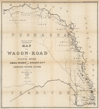
Author
Campbell, Albert
Full Title
Map of the Wagon-Road from Platte River via Omaha Reserve and Dakota City to Running Water River. Geo. L. Sites, Supt. 1858. T.S. Wagner's Lith. Philada. Department of the Interior, Pacific Wagon Roads. (Sen. Ex. Doc. No. 36. Ho. Ex. Doc. No. 108 - 2nd Sess. 35 Cong.)
Publisher
T.S. Wagner's Lith.
Author
Rand McNally and Company
Full Title
Commercial Atlas of America. Rand McNally AutoTrails Map, District Number 10, Iowa, E.Nebraska, S. Minnesota, N. Missouri, N.E. Kansas, W. Illinois.
Publisher
Rand McNally and Company
1-8 of 8
|